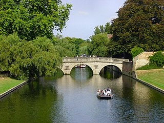
The River Cam is the main river flowing through Cambridge in eastern England. After leaving Cambridge, it flows north and east before joining the River Great Ouse to the south of Ely, at Pope's Corner. The total distance from Cambridge to the sea is about 40 mi (64 km) and is navigable for punts, small boats, and rowing craft. The Great Ouse also connects to England's canal system via the Middle Level Navigations and the River Nene. In total, the Cam runs for around 69 kilometres (43 mi) from its furthest source to its confluence with the Great Ouse.

Grantchester is a village and civil parish on the River Cam or Granta in South Cambridgeshire, England. It lies about two miles (3 km) south of Cambridge.

Coton is a small village and civil parish about three miles west of Cambridge in Cambridgeshire, England and about the same distance east of the Prime Meridian. It is in the district of South Cambridgeshire. The parish covers an area of 392 hectares. In the 2001 census it had a population of 773, with approximately 336 dwellings and 322 households. The population at the 2011 census was 910.

Darwin College is a constituent college of the University of Cambridge. Founded on 28 July 1964, Darwin was Cambridge University's first graduate-only college, and also the first to admit both men and women. The college is named after one of the university's most famous families and alumni, that of Charles Darwin. The Darwin family previously owned some of the land, Newnham Grange, on which the college now stands.

Sir Francis Darwin was a British botanist. He was the third son of the naturalist and scientist Charles Darwin.

The Ascension Parish Burial Ground, formerly known as the burial ground for the parish of St Giles and St Peter's, is a cemetery off Huntingdon Road in Cambridge, England. Many notable University of Cambridge academics are buried there, including three Nobel Prize winners.

Loxley is a village and a suburb of the city of Sheffield, England. It is a long linear community which stretches by the side of the River Loxley and along the B6077 for almost 2.5 miles (4 km). Loxley extends from its borders with the suburbs of Malin Bridge and Wisewood westward to the hamlet of Stacey Bank near Damflask Reservoir. The centre of the suburb is situated at the junction of Rodney Hill and Loxley Road where the old village green stands and this is located 3 miles (5 km) north west of Sheffield city centre. The suburb falls within the Stannington ward of the City of Sheffield.

Newnham or Newnham on Severn is a village in west Gloucestershire, England. It lies in the Royal Forest of Dean, on the west bank of the River Severn, approximately 10 miles south-west of Gloucester and three miles southeast of Cinderford. It is on the A48 road between Gloucester and Chepstow, Monmouthshire, Wales. The village has a parish council.

Grantchester Meadows is an open space in Grantchester, to the south of the city of Cambridge, England. It is part of the broad green flood plain from the pubs in Grantchester to the Ditton Plough, comprising Grantchester Meadows, The Lammas Land, the Backs, Jesus Green, Midsummer Common, and Stourbridge Common.

Arlingham is a village and civil parish in the Stroud District of Gloucestershire, England. The 2021 Census recorded a parish population of 533. The parish contains the hamlets of Milton End, Overton and Priding. The next parish to the east is Fretherne with Saul.

Trumpington is a village to the south of Cambridge, in the Cambridge district, in the county of Cambridgeshire, England. The village is an electoral ward of the City of Cambridge and a ward of South Cambridgeshire District Council. The 2011 Census recorded the ward's population as 8,034.
Olive Mary Wendy Nicol, Baroness Nicol was a British Labour Co-operative politician.

Paradise is a 2.2 hectare Local Nature Reserve in Newnham, a suburb of Cambridge. It is owned and managed by Cambridge City Council.

Silver Street is located in the southwest of central Cambridge, England. It links Queen's Road to the west with Trumpington Street to the east. The road continues west out of central Cambridge as Sidgwick Avenue.
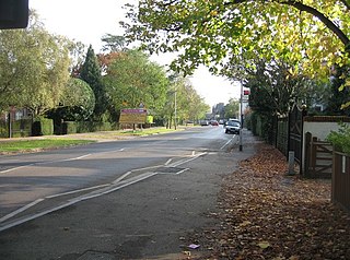
Barton Road is a major arterial road linking central Cambridge, England with Junction 12 of the M11 motorway to the southwest.

The Cambridge Whitefriars, or Newnham Whitefriars, were a community of Carmelite friars who first settled in Chesterton outside Cambridge in the thirteenth century. Although granted permission by Henry III to build a house there in 1247, they instead moved into a house in Newnham donated to them by Michael Malherbe in 1249. It was situated in the parish of St-Peter-outside-the-gate in Trumpington and so fell under the jurisdiction of the Hospital of St John the Evangelist. Extensive monastic cells, a cloister and a church were constructed on three acres of land in Newnham. In 1290, however, because frequent flooding made it difficult to attend lectures and acquire provisions, the friars obtained permission from Edward I to move to land on Milne Street within Cambridge. They remained there from 1292 until 1538, when, as a result of the dissolution of the monasteries under Henry VIII, their property was handed over to Queens' College, who demolished the monastic buildings. The site is now occupied by Walnut Tree Court and the college chapel. The only surviving remains can be seen in the well-preserved north wall of the Fellows' Garden, which formed the north wall of the Carmelite church. The locations of the sites in Chesterton and Newnham are unknown.
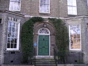
Newnham Grange is a Grade II listed house on Silver Street, Cambridge, next to the River Cam and The Backs. Since 1962 it has been part of Darwin College, Cambridge.

Martha Haskins, Lady Darwin, known as Maud Darwin, was an American socialite and the wife of the English Cambridge University astronomer Sir George Darwin.

Sheep's Green and Coe Fen is a 16.9 hectare Local Nature Reserve in Cambridge. It is owned and managed by Cambridge City Council.
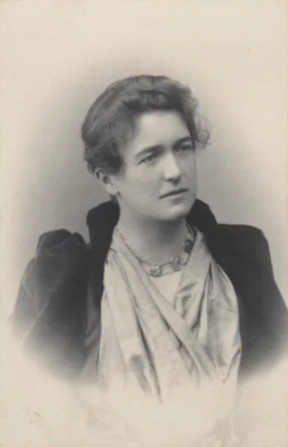
Ellen Wordsworth Darwin was an academic, a fellow and lecturer in English Literature at Newnham College in Cambridge (1879–1883), a member of the private and scholarly Ladies Dining Society at Cambridge and the second wife of the botanist Sir Francis Darwin, son of Charles Darwin. Their daughter was the poet Frances Cornford.

