
Zanzibar is an insular semi-autonomous region which united with Tanganyika in 1964 to form the United Republic of Tanzania. It is an archipelago in the Indian Ocean, 25–50 km (16–31 mi) off the coast of the African mainland, and consists of many small islands and two large ones: Unguja and Pemba Island. The capital is Zanzibar City, located on the island of Unguja. Its historic centre, Stone Town, is a World Heritage Site.

A tower block, high-rise, apartment tower, residential tower, apartment block, block of flats, or office tower is a tall building, as opposed to a low-rise building and is defined differently in terms of height depending on the jurisdiction. It is used as a residential, office building, or other functions including hotel, retail, or with multiple purposes combined. Residential high-rise buildings are also known in some varieties of English, such as British English, as tower blocks and may be referred to as MDUs, standing for multi-dwelling units. A very tall high-rise building is referred to as a skyscraper.
Public housing, also known as social housing, refers to affordable housing provided in buildings that are usually owned and managed by local government, central government, nonprofit organizations or a combination thereof. The details, terminology, definitions of poverty, and other criteria for allocation may vary within different contexts, but the right to rent such a home is generally rationed through some form of means-testing or through administrative measures of housing needs. One can regard social housing as a potential remedy for housing inequality. Within the OECD, social housing represents an average of 7% of national housing stock (2020), ranging from ~34% in the Netherlands to less than 1% in Colombia.

An apartment, flat, or unit is a self-contained housing unit that occupies part of a building, generally on a single story. There are many names for these overall buildings. The housing tenure of apartments also varies considerably, from large-scale public housing, to owner occupancy within what is legally a condominium or leasehold, to tenants renting from a private landlord.
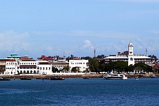
Stonetown of Zanzibar, also known as Mji Mkongwe, is the old part of Zanzibar City, the main city of Zanzibar, in Tanzania. The newer portion of the city is known as Ng'ambo, Swahili for 'the other side'. Stone Town is located on the western coast of Unguja, the main island of the Zanzibar Archipelago. Former capital of the Zanzibar Sultanate, and flourishing centre of the spice trade as well as the Indian Ocean slave trade in the 19th century, it retained its importance as the main city of Zanzibar during the period of the British protectorate. When Tanganyika and Zanzibar joined each other to form the United Republic of Tanzania, Zanzibar kept a semi-autonomous status, with Stone Town as its local government seat.

Clarence Samuel Stein was an American urban planner, architect, and writer, a major proponent of the garden city movement in the United States.
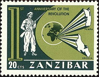
The Zanzibar Revolution began on 12 January 1964 and led to the overthrow of the Sultan of Zanzibar Jamshid bin Abdullah and his mainly Arab government by the island's majority Black African population.

Multifamily residential, also known as multidwelling unit (MDU), is a classification of housing where multiple separate housing units for residential inhabitants are contained within one building or several buildings within one complex. Units can be next to each other, or stacked on top of each other. Common forms include apartment building and condominium, where typically the units are owned individually rather than leased from a single building owner. Many intentional communities incorporate multifamily residences, such as in cohousing projects.

Swahili architecture is a term used to designate a whole range of diverse building traditions practiced or once practiced along the eastern and southeastern coasts of Africa. Rather than simple derivatives of Islamic architecture from the Arabic world, Swahili stone architecture is a distinct local product as a result of evolving social and religious traditions, environmental changes, and urban development.

Zanzibar City or Mjini District, often simply referred to as Zanzibar is one of two administrative districts of Mjini Magharibi Region in Tanzania. The district covers an area of 15.4 km2 (5.9 sq mi). The district is comparable in size to the land area of Nauru. The district has a water border to the west by the Indian Ocean. The district is bordered to the east by Magharibi District. The district seat is in Stonetown. The city is the largest on the island of Zanzibar. It is located on the west coast of Unguja, the main island of the Zanzibar Archipelago, north of the much larger city of Dar es Salaam across the Zanzibar Channel. The city also serves as the capital of the Zanzibar Urban/West Region. In 2022 its population was 219,007.
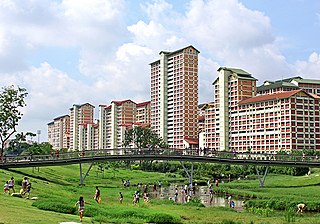
Public housing in Singapore is subsidised, built, and managed by the government of Singapore. Starting in the 1930s, the country's first public housing was built by the Singapore Improvement Trust (SIT) in a similar fashion to contemporaneous British public housing projects, and housing for the resettlement of squatters was built from the late 1950s. In the 1960s under the SIT's successor, the Housing and Development Board (HDB), public housing consisting of small units with basic amenities was constructed as quickly and cheaply as possible at high densities and used for resettlement schemes. From the late 1960s, housing programmes focused more on quality, public housing was built in new towns, and a scheme allowing residents to lease their flats was introduced. Throughout the 1970s and 1980s, more public housing options were provided for the middle class and efforts to increase community cohesion within housing estates were made. From the 1990s, the government began portraying public housing as an asset, introducing large-scale upgrading schemes and loosening regulations on the resale of public housing while additional housing programmes for the sandwich classes and elderly residents were introduced. Rising housing prices led to public housing being seen as an investment from the 2000s, and new technologies and eco-friendly features were incorporated into housing estates.
People have lived in Zanzibar for 20,000 years. The earliest written accounts of Zanzibar began when the islands became a base for traders voyaging between the African Great Lakes, the Somali Peninsula, the Arabian Peninsula, Iran, and the Indian subcontinent. Unguja offered a protected and defensible harbour, so although the archipelago had few products of value, Omanis and Yemenis settled in what became Zanzibar City as a convenient point from which to trade with towns on the Swahili Coast. They established garrisons on the islands and built the first mosques in the African Great Lakes Region.

Altitude 25 is an apartment building on Fairfield Road in the London Borough of Croydon, London. It is Croydon's fourth tallest building. The development was intended to regenerate a brownfield site near to East Croydon station. The building was completed in 2009, and has 26 floors of apartments up to floor 25, hence the name Altitude 25, a roof height of 82.00 and a structural height of 94 m (307 ft). It is part of the Croydon Vision 2020 regeneration project for a new generation of buildings in the town.

The Cass Park Historic District is a historic district in Midtown Detroit, Michigan, consisting of 25 buildings along the streets of Temple, Ledyard, and 2nd, surrounding Cass Park. It was listed on the National Register of Historic Places in 2005 and designated a city of Detroit historic district in 2016.

Architecture in Cardiff, the capital city of Wales, dates from Norman times to the present day. Its urban fabric is largely Victorian and later, reflecting Cardiff's rise to prosperity as a major coal port in the 19th century. No single building style is associated with Cardiff, but the city centre retains several 19th and early 20th century shopping arcades.

Michenzani is a large neighbourhood of Ng'ambo, the more modern part of Zanzibar City in Tanzania. It is located just across Creek Road, that separates the historical part of the city, Stone Town and Ng'ambo. The place is mostly known for the Plattenbauten, i.e., the large apartment blocks that were built here in the late 1960s and early 1970s with the aid of East Germany.
The following is a timeline of the history of the city of Dar es Salaam, Tanzania.
The following is a timeline of the history of Zanzibar City, Unguja island, Zanzibar, Tanzania. The city is composed of Ng'ambo and Stone Town. Until recently it was known as Zanzibar Town.

Antoni Scholtens Folkers is a Dutch architect, urbanist and researcher. Folkers studied at the Faculty of Architecture and Urban Planning at Delft University of Technology where he also received his Ph.D. in 2011. His doctoral dissertation was later published as the book Modern Architecture in Africa. Folkers is one of the founding partners of the research and educational platforms ArchiAfrika and African Architecture Matters.
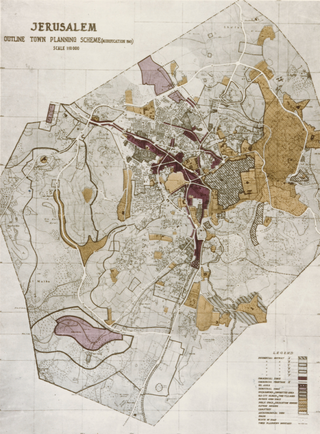
Henry Kendall (1903–1983) was a British architect, who worked as an urban planner, in British colonies and former colonies.
