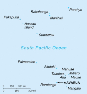
The Cook Islands can be divided into two groups: the Southern Cook Islands and the Northern Cook Islands. The country is located in Oceania, in the South Pacific Ocean, about one-half of the way from Hawaii to New Zealand.

Kalāheo is an unincorporated community and census-designated place (CDP) in Kauaʻi County, island of Kauaʻi, Hawaiʻi, United States. The population was 4,595 at the 2010 census, up from 3,913 at the 2000 census.

Kaumakani is a census-designated place (CDP) in Kauaʻi County, Hawaiʻi, United States. The population was 749 at the 2010 census, up from 607 at the 2000 census.

Kōloa is an unincorporated community and census-designated place (CDP) in Kauaʻi County, Hawaiʻi, United States. The population was 2,144 at the 2010 census, up from 1,942 at the 2000 census. The first successful sugarcane plantation in the Hawaiian Islands was started here in 1835. It became a part of Grove Farm in 1948.

Mokena is a village in Will County, Illinois, United States. The population was 18,740 at the 2010 census. A special census conducted in 2019 found that the population had increased to 20,159.

Little Cornwallis Island is one of the Canadian Arctic islands in Nunavut, Canada. It is located at 75°30'N 96°30'W, between Cornwallis Island and Bathurst Island in McDougall Sound, and measures 412 km2 (159 sq mi). It is uninhabited.
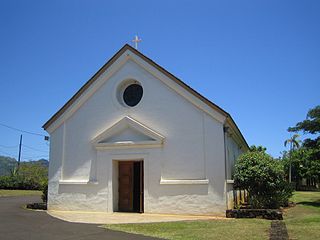
Saint Raphael Catholic Church in Koloa is a parish of the Roman Catholic Church of Hawaii in the United States. Located in Koloa on the island of Kauai, the church falls under the jurisdiction of the Diocese of Honolulu and its bishop. It is named after Saint Raphael.
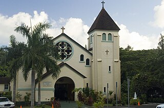
Immaculate Conception Catholic Church in Lihue is a parish of the Roman Catholic Church of Hawaii in the United States. Located in Lihue on the island of Kauai, the church falls under the jurisdiction of the Diocese of Honolulu and its bishop. It is named after the Blessed Virgin Mary. The church was built in 1924.

The National Tropical Botanical Garden (NTBG) is a Hawaii-based not-for-profit institution dedicated to tropical plant research, conservation, and education. It operates a network of botanical gardens and preserves in Hawaii and Florida.
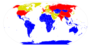
The Treaty of Rarotonga is the common name for the South Pacific Nuclear Free Zone Treaty, which formalises a Nuclear-Weapon-Free Zone in the South Pacific. The treaty bans the use, testing, and possession of nuclear weapons within the borders of the zone.
Kupolo is a populated place in south-east Kauai in the Hawaiian Islands.
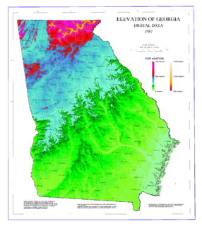
The geography of Georgia describes a state in the Southeastern United States in North America. The Golden Isles of Georgia lie off the coast of the state. The main geographical features include mountains such as the Ridge-and-valley Appalachians in the northwest, the Blue Ridge Mountains in the northeast, the Piedmont plateau in the central portion of the state and Coastal Plain in the south. The highest area in Georgia is Brasstown Bald which is 1,458 m (4,784 ft) above sea level, while the lowest is at sea level, at the Atlantic Ocean. Georgia is located at approximately 33° N 83.5° W. The state has a total area of 154,077 km2 (59,489 sq mi) and the geographic center is located in Twiggs County.

The Kingdom of Rarotonga, named after the island of Rarotonga, was an independent kingdom established in the present-day Cook Islands in 1858. In 1888 it became a protectorate of the United Kingdom by its own request. In 1893 the name was changed to the Cook Islands Federation.

Vân Đồn is a rural district of Quảng Ninh Province in the Northeast region of Vietnam. As of 2003 the district had a population of 39,157. The district covers an area of 551 km². The district capital lies at Cái Rồng. The district is selected as a Special Economic Zone, and is rapidly being developed. It is connected by motorway to Hai Phong and Ha Long, and served by Van Don International Airport.

The Cook Islands Federation was created in 1891, after the Kingdom of Rarotonga was given the island of Aitutaki. It lasted until 1901, when it was given to New Zealand.
Matavera is the smallest of the five districts that make up the island of Rarotonga in the Cook Islands.
Arorangi is one of the five districts that make up the island of Rarotonga in the Cook Islands. It is located in the west of the island, to the northwest of the district of Titikaveka, and southwest of the district of Avarua.

Nawiliwili Beach Park is a beach park and port on the south-east coast of the island of Kauai in the Hawaiian Islands. It is located on Nāwiliwili Bay at 21°57′33″N159°21′10″W, about 1.9 miles (3.1 km) south of Līhuʻe. It is at the south end of Hawaii Route 51, known as Rice Street. Just to the west is Niumalu Beach Park. Across Nāwiliwili Bay is Kawai Point.
Takamoa Theological College is a Bible school located in Rarotonga, Cook Islands. It was founded by the noted Congregationalist missionary Aaron Buzacott (1800-1864). It offers a Diploma of Theology and a Certificate of Bible Studies. The college trains pastors for the Cook Islands Christian Church. It has 23 branches in the Cook Islands, 20 in New Zealand, and 12 in Australia.
Hāʻena is an unincorporated community and census-designated place on the island of Kauai in Kauai County, Hawaii, United States. Its population was 431 as of the 2010 census. The community is located on the north side of the island along Hawaii Route 560.

