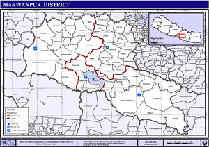
Makwanpur District(Nepali: मकवानपुर जिल्ला; Listen , a part of Bagmati Province, earlier a part of Narayani Zone, is one of the seventy-seven districts of Nepal. The district, with Hetauda as its district headquarter, as well as pradesh headquarter covers an area of 2,426 km2 and had a population of 392,604 in 2001 and 420,477 in 2011.

Bandipur is a hilltop settlement and a rural municipality in Tanahun District, Gandaki province of Nepal. Bandipur is primarily known for its preserved, old time cultural atmosphere. At the time of the 2011 Nepal census it had a population of total 15,591 people living in 3,750 individual households.

Bhimphedi, is a village located in the Bhimphedi Rural Municipality of Makwanpur District of Bagmati Province of Nepal. This village is known for its bazaar (marketplace). Bismuth ore is mined here.

Hetauda is a sub-metropolitan city in the Makwanpur District of Bagmati Province in central Nepal. It is the administrative headquarters of the Makwanpur District and the capital of Bagmati Province as declared by majority Provincial Assembly Members on 12 January 2020. It is one of the largest cities of Nepal. At the time of the 2015 Nepal census, it had a population of 153,875 people. The city had a population of 195,951 in 2021.

A village development committee in Nepal was the lower administrative part of its Ministry of Federal Affairs and Local Development. Each district had several VDCs, similar to municipalities but with greater public-government interaction and administration. There were 3,157 village development committees in Nepal. Each village development committee was further divided into several wards depending on the population of the district, the average being nine wards.
The 1991 Nepal census was a widespread national census conducted by the Nepal Central Bureau of Statistics.
Narayansthan is a village development committee in Baglung District in the Dhaulagiri Zone of central Nepal.It is located above the bank of Kali gandaki River. Now, it has become one of the major important place in baglung. They have planned to construct the domestic Airport. At the time of the 2011 Nepal census it had a population of 2,876 and had 781 houses in the town. The major castes living in the VDC are Brahman, Chhetry and Newar. There are 2 high schools - Janatadhan Higher School and Ganesh Secondary School and one campus. Krishna Gandaki Campus is at the premises of Janatadhan HSS. Ganesh Secondary School, one of the best schools in the region is known for its quality education movement. Established in 1957 [2014 BS] by Soldier Board (India), Ganesh Secondary School is one of the oldest schools. In 1964 [2021 BS], the Indian Soldier Board stopped its grant. Since there was no school support mechanism developed from the Government of Nepal, the school passed through many ups and downs. After Modern Education Act came in effect in 1971 BS [2028 BS], the school merged with Janatadhan Higher Secondary School. In 1980 [2037 BS], the school was reopened.

Duwakot is a settlement and former Village Development Committee—now part of Changunarayan municipality, located in Bhaktapur district of Bagmati Province in central Nepal. At the time of the 1991 Nepal census, it had a population of 5,157 with 905 houses in it.
Mulpani is a village and former Village Development Committee that is now part of Kageshwari-Manohara Municipality in Kathmandu District in Province No. 3 of central Nepal. Mulpani was previously known as Bhaimal, meaning "no fear". At the time of the 1991 Nepal census it had a population of 4,718 living in 843 households. The main occupation of the people living in this village is agriculture. Mulpani is surrounded by Bagmati and Manohara river. Mulpani is famous for the Nepal's biggest International Cricket Ground, known as Mulpani Cricket Stadium, which is under construction. In the recent years, Mulpani has seen much change in its infrastructure and people as well. The main occupation in Mulpani was agriculture but now employment is more diverse.
Kaskikot, commonly known as Kaski, is a Ward no. 24 of the Pokhara metropolitan city. It was earlier a part of the village development committee in Kaski District, a region in northern-central Nepal.
Sundarbazar is a Municipality in Lamjung District in the Gandaki Province of northern-central Nepal. The Sundarbazar Municipality was formed by merging the existing Village Development Committees i.e. Bhoteodar, Sundarbazar, Parewadanda, Tarku and Kuncha as one of the 61-municipalities category on 2071. As of 2011 Nepal census, it had 11,230 male population and 15,445 female population living in 7,512 households.
Matihani is a municipality situated in Mahottari District of Nepal. The Municipality is well known for its historical significance and its festivities. The municipality was formed in 2016 from its current 9 wards from 9 former VDCs. It occupies an area of 29.02 sq. km with a total population of 31,026.

Katahariya is a municipality in Rautahat District in the Narayani Zone of south-eastern Nepal. Before September 2017, Katahariya was one of the Village Development Committees with 8 wards. At the time of the 1991 Nepal census, it had a population of 4,619 people living in 835 individual households. Katahariya is famous for its vegetables and cattle market. It has a well-maintained Farmers' market (vegetable) and Cattle (domestic-animal) market. Katahariya is a fast-growing VDC, with the main occupations of local people being business and farming.
Bhainse is a village development committee in the Bhimphedi Rural Municipality of Makwanpur District in the Bagmati Province of southern Nepal. At the time of the 1991 Nepal census it had a population of 6615 people living in 1105 individual households.
Ipa Panchakanya is a village development committee in the Bhimphedi Rural Municipality of Makwanpur District in the Bagmati Province of southern Nepal. At the time of the 1991 Nepal census it had a population of 2335 people living in 395 individual households.
Kogate is a village development committee in the Bhimphedi Rural Municipality of Makwanpur District in the Bagmati Province of southern Nepal. At the time of the 1991 Nepal census it had a population of 1,429.

Letang, "लेटाङ " is a Municipality in Morang District in the Province No. 1 of south-eastern Nepal. It was formed by merging the existing Village Development Committees of Letang, Jante, Warrangi and Bhogateni. This municipality is situated in Hilly Region as well as Terai Region. Letang is full of natural beauty. Previously it was called Letang Bhogateni but now it's known as Letang.
Thumpakhar is a village in Sindhupalchok District in the Bagmati Zone of central Nepal. In the 1991 Nepal census, it had a population of 5210, with 1023 houses.

The Churia Tunnel is a 500 m (1,600 ft)-long highway tunnel carved through the churia hill between Makwanpur and Bara of Nepal. It was constructed connecting the country's first motorable road between Amlekhganj in the terai and Bhimphedi settlement of Makwanpur, the point of entry into Kathmandu which served as a dry port, in the trade route between Kathmandu and Raxaul.
Bhimphedi is a Rural municipality located within the Makawanpur District of the Bagmati Province of Nepal. The rural municipality spans 245.27 square kilometres (94.70 sq mi) of area, with a total population of 23,344 according to a 2011 Nepal census.