Related Research Articles

Platinum is a city in Bethel Census Area, Alaska, United States. The population was 61 at the 2010 census, up from 41 in 2000.
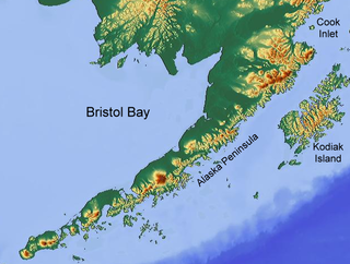
Bristol Bay is the easternmost arm of the Bering Sea, at 57° to 59° North 157° to 162° West in Southwest Alaska. Bristol Bay is 400 km (250 mi) long and 290 km (180 mi) wide at its mouth. A number of rivers flow into the bay, including the Cinder, Egegik, Igushik, Kvichak, Meshik, Nushagak, Naknek, Togiak, and Ugashik.

Birch Creek is a 150-mile (240 km) tributary of the Yukon River in the U.S. state of Alaska. Beginning at the confluence of Ptarmigan and Eagle creeks near Porcupine Dome, it flows southwest, then south under the Steese Highway and into the Steese National Conservation Area. It then turns east, then north, again passing under the Steese Highway and entering the Yukon Flats National Wildlife Refuge. Turning northwest, it ends where it splits into two distributaries, Lower Mouth Birch Creek and Upper Mouth Birch Creek, near Birch Creek, Alaska. The distributaries flow into the Yukon River at separate locations downstream of Fort Yukon.

Pebble Mine is the common name of a proposed copper-gold-molybdenum mining project in the Bristol Bay region of Southwest Alaska, near Lake Iliamna and Lake Clark. It was discovered in 1987, optioned by Northern Dynasty Minerals in 2001, explored in 2002, and drilled from 2002-2013 with discovery in 2005. Preparing for the permitting process began and administrative review lasted over 13 years.
Gold mining in Colorado, a state of the United States, has been an industry since 1858. It also played a key role in the establishment of the state of Colorado.

Candle is an unincorporated community in the Northwest Arctic Borough of the U.S. state of Alaska. It is situated on the west bank of the Kiwalik River at Candle Creek. It was founded around 1901 as a mining camp, named for the adjacent creek. The post office was established in 1902.

Gold Rush is a reality television series that airs on Discovery and its affiliates worldwide. The series follows the placer gold mining efforts of various family-run mining companies, initially in Alaska, but then mostly in the Klondike region of Dawson City, Yukon, Canada. Prior seasons also included mining efforts in Guyana, Oregon, and Colorado. As of 2024 the show has aired 14 seasons.

The Silver Bow Basin, often written as Silverbow Basin, is a valley located 2.4 miles (3.9 km) northeast of Juneau, Alaska, USA. It is situated on Gold Creek in an area north of Icy Gulch, and approximately 1.5 miles (2.4 km) north of Gastineau Peak. A trail from Juneau leads directly to the mountainside. The basin was the site of the earliest gold discovery in the Juneau area, leading to the establishment of the town called Juneau.

William Henry Bay is a waterway in the U.S. state of Alaska. It is located near Haines in the Alexander Archipelago. The only commercial copper deposit in Southeast Alaska situated north of Prince of Wales Island was located in the bay. Significant gold and strategic mineral anomalies were found at William Henry Bay during surveys in 2011.

The Juneau gold belt is located in the southeastern portion of the U.S. state of Alaska. This belt is approximately 100 miles (160 km) in length, north/northwest-trending, and extends from Berners Bay southeastward to Windham Bay, 60 miles (97 km) southeast of Juneau, and includes Douglas Island. The belt contains over 200 gold-quartz-vein deposits with production nearing 7,000,000 ounces (200,000,000 g) of gold. More than three-quarters of Alaska's lode gold was mined from the Juneau gold belt.
Gold Creek is a waterway in the southeastern section of the U.S. state of Alaska. It is located in the Silver Bow Basin at the edge of Juneau. In 1880, Chief Kowee revealed to prospectors Joe Juneau and Richard Harris the presence of gold in Gold Creek; the city of Juneau was founded in the same year. Named by miners, the name was first published in 1883.
Candle Creek is a western tributary of the Kiwalik River, located on the Seward Peninsula of the U.S. state of Alaska. The unincorporated community of Candle is less than a mile away, while the village of Kiwalik is about 13 miles (21 km) away. The creek's name is attributed to the resemblance of the trees on the banks of the creek to candles when they are covered with snow. With the discovery of gold in 1901, Candle Creek's reputation as a top gold-yielding site was fixed.
Solomon River is a waterway in the U.S. state of Alaska, near Nome.
Bluestone River is a waterway located on the Seward Peninsula in the U.S. state of Alaska. A tributary of the Tuksuk Channel from the south, Bluestone is a north-flowing stream situated 11 miles (18 km) southeast of Teller. It was named in 1900 by Edward Chester Barnard, topographer of the United States Geological Survey.

Grantley Harbor is a waterway located at the bay of Port Clarence, Alaska, on the Seward Peninsula in the U.S. state of Alaska. The inner harbor at the entrance to the northeast corner of the bay was named after Lord Grantley.
Charles D. Lane was a US millionaire mine owner, who is recognized as a founder of Nome, Alaska. Lane was born in Palmyra, Missouri November 15, 1840. His parents were Virginians of Scottish descent. He moved to California with his father in 1852 and almost immediately took up mining. After an unsuccessful attempt to develop a lode mine in Nevada, he achieved his first success on the Snake River in Idaho, followed some years later by a major strike at the Utica Mine at Angels, California. Lane also developed the Fortuna Mine in Arizona.
Valdez Creek is one of the small headwater tributaries of Susitna River in the U.S. state of Alaska.
Troublesome Creek is a stream in Yukon–Koyukuk Census Area, Alaska, in the United States. It is a tributary of Hess Creek.

Glacier Creek is a 10 miles long stream flowing out of the Chugach Mountains, which enters the Turnagain Arm of Cook Inlet near Girdwood, Alaska.
Amalga is a former gold-mining town outside of Juneau, Alaska. The area is now part of the Tongass National Forest. The Library of Congress has a photograph of Amalga by Winter & Pond in its collection. The area was once homesteaded and farmed. A horse tram brought goods delivered by steamship to the mine.
References
- ↑ EPA, US (2021-12-06). "How's My Waterway?". US EPA. Retrieved 2024-05-15.
- ↑ "Nomination Details - Anadromous Waters Catalog - Sport Fish". www.adfg.alaska.gov. Retrieved 2024-05-15.
- ↑ "Negromoon Creek". Western Mining History. Retrieved 2024-05-15.
- ↑ Fourth Report of the United States Geographic Board. Washington: Government Printing Office. 1916. p. 229.
- ↑ Bulletin. U.S. Government Printing Office. 1910. p. 334.
65°04′52″N160°27′54″W / 65.081°N 160.465°W