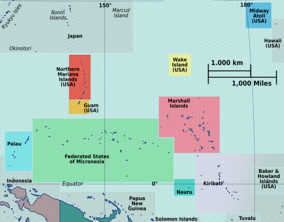
The Federated States of Micronesia, or simply Micronesia, is an island country in Micronesia, a subregion of Oceania. The federation consists of four states—from west to east, Yap, Chuuk, Pohnpei, and Kosrae—that are spread across the western Pacific. Together, the states comprise around 607 islands that cover a longitudinal distance of almost 2,700 km (1,700 mi) just north of the equator. They lie northeast of Indonesia and Papua New Guinea, south of Guam and the Marianas, west of Nauru and the Marshall Islands, east of Palau and the Philippines, about 2,900 km (1,800 mi) north of eastern Australia, 3,400 km (2,100 mi) southeast of Japan, and some 4,000 km (2,485 mi) southwest of the main islands of the Hawaiian Islands.

Micronesia is a subregion of Oceania, consisting of approximately 2,000 small islands in the Northwestern Pacific Ocean. It has a close shared cultural history with three other island regions: Maritime Southeast Asia to the west, Polynesia to the east, and Melanesia to the south—as well as with the wider community of Austronesian peoples.

Ulithi is an atoll in the Caroline Islands of the western Pacific Ocean, about 191 km (103 nmi) east of Yap, within Yap State.

The Philippine Sea is a marginal sea of the Western Pacific Ocean east of the Philippine Archipelago and the largest sea in the world, occupying an estimated surface area of 5 million square kilometers. The Philippine Sea Plate forms the floor of the sea. Its western border is the first island chain to the west, comprising the Ryukyu Islands in the northwest and Taiwan in the west. Its southwestern border comprises the Philippine islands of Luzon, Catanduanes, Samar, Leyte, and Mindanao. Its northern border comprises the Japanese islands of Honshu, Shikoku and Kyūshū. Its eastern border is the second island chain to the east, comprising the Bonin Islands and Iwo Jima in the northeast, the Mariana Islands in the due east, and Halmahera, Palau, Yap and Ulithi in the southeast. Its southern border is Indonesia's Morotai Island.
Tioman Island is 32 kilometres off the east coast of Rompin District, Pahang, Malaysia. It is 39 kilometres long and 12 kilometres wide and has seven villages, the largest and most populous being Kampung Tekek on the central western coast. The densely forested island is sparsely inhabited, and is surrounded by numerous coral reefs, making it a popular scuba diving, snorkelling, and surfing spot. There are many resorts and chalets for tourists around the island, which has duty-free status.
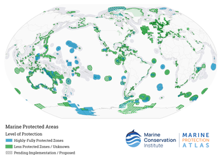
Marine protected areas (MPAs) are protected areas of the world's seas, oceans, estuaries or in the US, the Great Lakes. These marine areas can come in many forms ranging from wildlife refuges to research facilities. MPAs restrict human activity for a conservation purpose, typically to protect natural or cultural resources. Such marine resources are protected by local, state, territorial, native, regional, national, or international authorities and differ substantially among and between nations. This variation includes different limitations on development, fishing practices, fishing seasons and catch limits, moorings and bans on removing or disrupting marine life. In some situations, MPAs also provide revenue for countries, potentially equal to the income that they would have if they were to grant companies permissions to fish. The value of MPA to mobile species is unknown.

Yap State is one of the four states of the Federated States of Micronesia, located in the westernmost portion of the country. The state borders Palau to the southwest, Guam to the north, and Chuuk State to the east. According to the state's population census carried out in 2020, the total population is 11,577 residing across a total area of 119.54 sq km, though a large majority of the area is water. The only town area in the state, Colonia, serves as the state capital.
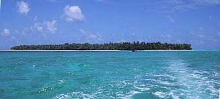
Satawal is a solitary coral atoll of one island with about 500 people on just over 1 km2 located in the Caroline Islands in the Pacific Ocean. It forms a legislative district in Yap State in the Federated States of Micronesia. Satawal is the easternmost island in the Yap island group and is located approximately 70 kilometers (43 mi) east of Lamotrek.

Hol Chan Marine Reserve is a marine reserve close to Ambergris Caye and Caye Caulker, off the coast of Belize. It covers approximately 18 km² (4,448 acres) of coral reefs, seagrass beds, and mangrove forest. Hol Chan is Mayan for "little channel".

The Coral Triangle (CT) is a roughly triangular area in the tropical waters around the Philippines, Indonesia, Malaysia, Papua New Guinea, the Solomon Islands and Timor-Leste. This area contains at least 500 species of reef-building corals in each ecoregion. The Coral Triangle is located between the Pacific and Indian oceans and encompasses portions of two biogeographic regions: the Indonesian-Philippines Region, and the Far Southwestern Pacific Region. As one of eight major coral reef zones in the world, the Coral Triangle is recognized as a global centre of marine biodiversity and a global priority for conservation. Its biological resources make it a global hotspot of marine biodiversity. Known as the "Amazon of the seas", it covers 5.7 million square kilometres (2,200,000 sq mi) of ocean waters. It contains more than 76% of the world's shallow-water reef-building coral species, 37% of its reef fish species, 50% of its razor clam species, six out of seven of the world's sea turtle species, and the world's largest mangrove forest. In 2014, the Asian Development Bank (ADB) reported that the gross domestic product of the marine ecosystem in the Coral Triangle is roughly $1.2 trillion per year and provides food to over 120 million people. According to the Coral Triangle Knowledge Network, the region annually brings in about $3 billion in foreign exchange income from fisheries exports, and another $3 billion from coastal tourism revenues.
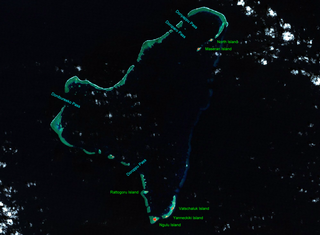
Ngulu Atoll is a coral atoll of three islands in the Caroline Islands in the Pacific Ocean, and forms a legislative district in Yap State in the Federated States of Micronesia. Ngulu extends for 36 kilometers (22 mi) by 22 kilometers (14 mi) with 18 reef segments enclosing a deep central lagoon of 382 square kilometers (147 sq mi). The eastern portion of the reef is deeply submerged. Its total land area of the nine islets is only 0.4 square kilometers (0.15 sq mi). Nugulu is located approximately 104 kilometers (65 mi) south-southwest of Yap and is the westernmost atoll in the Federated States of Micronesia. The population of Ngulu was 26 in 2000.

Bunaken National Park is a marine park in the north of Sulawesi Island, Indonesia. The park is located near the centre of the Coral Triangle, providing habitat to 390 species of coral as well as many fish, mollusks, reptiles and marine mammal species. The park is representative of Indonesian tropical water ecosystems, consisting of seagrass plains, coral reefs and coastal ecosystems.

Mangrove ecosystems represent natural capital capable of producing a wide range of goods and services for coastal environments and communities and society as a whole. Some of these outputs, such as timber, are freely exchanged in formal markets. Value is determined in these markets through exchange and quantified in terms of price. Mangroves are important for aquatic life and home for many species of fish.
The Funafuti Conservation Area is a marine conservation area covering 33 square kilometers of reef, lagoon and motu (islets) on the western side of Funafuti atoll in Tuvalu. The marine environment of the conservation area includes reef, lagoon, channel and ocean; and are home to many species of fish, corals, algae and invertebrates. The islets are nesting sites for the green sea turtle and Fualopa hosts a breeding colony of black noddy.

Olimarao Atoll is an uninhabited atoll with a land area of 0.2 km2 in the State of Yap in the Federated States of Micronesia. It is located 36 kilometers northwest of Elato and 860 kilometers southeast of Yap island. Olimarao belongs administratively to Elato.
Sisters’ Islands Marine Park is a 400,000 square metre(40ha) marine park located in Southern Islands planning area, Singapore, which was designated a marine protected area (MPA) by the Government of Maritime and Port Authority of Singapore in 2014. The park encompasses the land and waters surrounding Sisters' Islands, and also covers the western coasts of both St John's Island and Pulau Tekukor.
The Coral Triangle Initiative on Coral Reefs, Fisheries, and Food Security (CTI-CFF), or the Coral Triangle Initiative (CTI), is a multilateral collaborative partnership among six countries. Partners work together to sustain living marine and coastal resources by addressing crucial issues such as food security, climate change, and marine biodiversity.

The coral reefs of Tuvalu consist of three reef islands and six atolls, containing approximately 710 km2 (270 sq mi) of reef platforms. The islands of the Tuvalu archipelago are spread out between the latitude of 5° to 10° south and longitude of 176° to 180°, west of the International Date Line. The islands of Tuvalu are volcanic in origin. On the atolls, an annular reef rim surrounds the lagoon, and may include natural reef channels. The reef islands have a different structure to the atolls, and are described as reef platforms as they are smaller tabular reef platforms that do not have a salt-water lagoon, although they may have a completely closed rim of dry land, with the remnants of a lagoon that has no direct connection to the open sea or that may be drying up.

Climate change in Fiji is an exceptionally pressing issue for the country - as an island nation, Fiji is particularly vulnerable to rising sea levels, coastal erosion and extreme weather. These changes, along with temperature rise, will displace Fijian communities and will prove disruptive to the national economy - tourism, agriculture and fisheries, the largest contributors to the nation's GDP, will be severely impacted by climate change causing increases in poverty and food insecurity. As a party to both the Kyoto Protocol and the Paris Climate Agreement, Fiji hopes to achieve net-zero emissions by 2050 which, along with national policies, will help to mitigate the impacts of climate change.

The Coral reefs of the Solomon Islands consists of six major islands and over 986 smaller islands, in Oceania, to the east of Papua New Guinea and northwest of Vanuatu. The Solomon Islands lie between latitudes 5° and 13°S, and longitudes 155° and 169°E. The distance between the westernmost and easternmost islands is about 1,500 km (930 mi). The Santa Cruz Islands are situated north of Vanuatu and are especially isolated at more than 200 km (120 mi) from the other islands. The Solomon Islands has the 22nd largest Exclusive Economic Zone of 1,589,477 km2 (613,701 sq mi) of the Pacific Ocean.