
Dumfries is a market town and former royal burgh in Dumfries and Galloway, Scotland, near the mouth of the River Nith on the Solway Firth, 25 miles (40 km) from the Anglo-Scottish border. Dumfries is the county town of the historic county of Dumfriesshire.

Dumfries and Galloway is one of the 32 unitary council areas of Scotland, located in the western part of the Southern Uplands. It is bordered by East Ayrshire, South Ayrshire, and South Lanarkshire to the north; Scottish Borders to the north-east; the English county of Cumbria, the Solway Firth, and the Irish Sea to the south, and the North Channel to the west. The administrative centre and largest settlement is the town of Dumfries. The second largest town is Stranraer, located 76 miles (122 km) to the west of Dumfries on the North Channel coast.

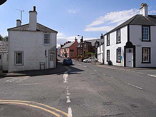
Thornhill is a village in the Mid Nithsdale area of Dumfries and Galloway, Scotland, south of Sanquhar and north of Dumfries on the main A76 road. Thornhill sits in the Nithsdale valley with the Carsphairn and Scaur range to the west and the Lowther hills to the east. It was initially a small village, planned and built in 1717 on the Queensberry Estate on the road linking Dumfries to Glasgow. The Earl of Queensberry initially named the village 'New Dalgarnock' however the name did not achieve popular approval.

Kirkcudbrightshire, or the County of Kirkcudbright or the Stewartry of Kirkcudbright is one of the historic counties of Scotland, covering an area in the south-west of the country. Until 1975, Kirkcudbrightshire was an administrative county used for local government. Since 1975, the area has formed part of Dumfries and Galloway for local government purposes. Kirkcudbrightshire continues to be used as a registration county for land registration. A lower-tier district called Stewartry covered the majority of the historic county from 1975 to 1996. The area of Stewartry district is still used as a lieutenancy area. Dumfries and Galloway Council also has a Stewartry area committee.

Dumfriesshire or the County of Dumfries or Shire of Dumfries is a historic county and registration county in southern Scotland. The Dumfries lieutenancy area covers a similar area to the historic county.

The River Nith is a river in south-west Scotland. The Nith rises in the Carsphairn hills of East Ayrshire, between Prickeny Hill and Enoch Hill, 4.4 miles (7.1 km) east of Dalmellington. For the majority of its 70 miles (110 km) course it flows in a south-easterly direction through Dumfries and Galloway and then into the Solway Firth at Airds Point.
Penpont is a village about 2 miles (3 km) west of Thornhill in Dumfriesshire, in the Dumfries and Galloway region of Scotland. It is near the confluence of the Shinnel Water and Scaur Water rivers in the foothills of the Southern Uplands. It has a population of about 400 people.

Sanquhar Castle, now a ruin, was built in the 13th century; the ruins are situated north east of Dumfries overlooking the River Nith. Situated on the southern approach to the former royal burgh of Sanquhar in Dumfries and Galloway, south west Scotland, it sits on the trail of the Southern Upland Way. The castle is a stronghold bounded on the west by the River Nith, to the north by a burn, and made strong by a deep ditch running the remainder of the boundary.
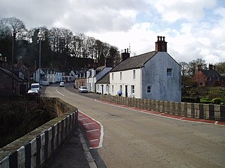
Carronbridge is a village in the parish of Morton in Dumfries and Galloway, Scotland. The village is at the junction of the A76 and A702 roads approximately 1 mile (2 km) north of Thornhill. The hamlet of Enterkinfoot lies slightly to the north. To the west of the village the Carron Water flows into the River Nith. Carronbridge Sawmill is in the village and is a Category B listed building built in the 1850s for the Duke of Buccleuch's Drumlanrig estate.

Durisdeer is a small village in Dumfries and Galloway, south-west Scotland, and in the historic county of Dumfries-shire. It lies 6 miles (9.7 km) north of Thornhill, above the Carron Water, a tributary of the Nith.

Cargenbridge is a village located in Dumfries and Galloway, United Kingdom, southwest of Dumfries. It is in Troqueer parish, in the historic county of Kirkcudbrightshire.

Thornhill is a closed station. It served the country town of Thornhill in Dumfries and Galloway. The station site is a mile or so from the town. Four miles north of Thornhill is Drumlanrig Castle, home to the Duke of Buccleuch and Queensberry. The Glasgow and South Western main line rail route between Kilmarnock and Dumfries is forced to make a long detour to the east of Thornhill and through a long tunnel, rather than the more logical route nearer Thornhill town centre and up the Nith Valley, so as not to be seen from the Buccleuch estate. The distance of the station from Thornhill may be one reason that passenger use was light and stopping services ended in 1965. There was formerly a busy livestock market near to the station, which eventually closed around 2001.

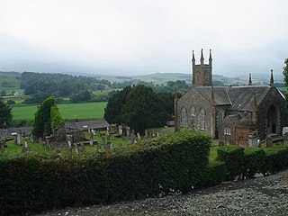
Closeburn is a village and civil parish in Dumfries and Galloway, Scotland. The village is on the A76 road 2+1⁄2 miles (4 km) south of Thornhill. In the 2001 census, Closeburn had a population of 1,119. Closeburn is recorded as Killosbern in 1185. The first element of the name is Gaelic cill 'cell or church'. The second element is a saint's name, but none has definitely been identified.

The Carsphairn and Scaur Hills are the western and eastern hills respectively of a hill range in the Southern Uplands of Scotland. Ordnance Survey maps don't have a general name for the hill area as a whole. Also, Ordnance Survey use "Scar" rather than the local spelling of "Scaur" - the word is pronounced as "Scar" however. In their Landranger Series of maps, it requires four separate sheets to cover the area.

Troqueer is a former village and a parish in the historic county of Kirkcudbrightshire in Dumfries and Galloway on the west side of the River Nith. The eastern-side was merged with Dumfries to the east in 1929, and today eastern Troqueer is a suburb of Dumfries.
Glencairn is an ecclesiastical and civil parish in Dumfries and Galloway, Scotland.

Dalgarnock, Dalgarno, Dalgarnoc was an ancient parish and a once considerable sized village in the Nithsdale area of Dumfries and Galloway, Scotland, south of Sanquhar and north of Dumfries that enclosed the parish of Closeburn but was annexed to Closeburn in 1606 following the Reformation, separated again in 1648 and finally re-united in 1697, as part of the process that established the Presbyterian Church of Scotland. It was a burgh of regality bordering the River Nith and Cample Water and held a popular market-tryst or fair from medieval times until 1601 when the Earl of Queensberry had them transferred to Thornhill, commemorated in song by Robert Burns, shortly before its demise and now only a remote churchyard remains at a once busy site.

Enterkinfoot is a small village or hamlet which lies 6 miles (9.7 km) north of Thornhill on the A76 on the route to Sanquhar, in Dumfriesshire, Durisdeer Parish, in Dumfries and Galloway, south-west Scotland. Its original nucleus was the old mill with associated buildings, the school and the famous Enterkin Pass and path that followed the course of the Enterkin Glen to Wanlockhead and from there to Edinburgh. The site features the A76 that runs through the centre of Enterkinfoot, the River Nith and the Enterkin Burn that once powered the mill before joining the Nith. The area is famous for its association with the Covenanters.
Curriestanes cursus is a large neolithic ditched enclosure on the outskirts of Dumfries, in the parish of Troqueer, Dumfries and Galloway. It is visible only from aerial photography. It is, along with Pict's Knowe, one of two scheduled monuments in Troqueer parish.

Lochar Water is a stream located in Dumfries and Galloway. It flows for about 10 miles or 16 km, mainly in a southerly direction, roughly parallel to the River Nith to the west and the River Annan to the east. It is formed by the confluence of Park Burn and Amisfield Burn, and skirts the eastern side of the town of Dumfries, and flows through an extensive low-lying area and former raised peat land known as Lochar Moss, before flowing into the Solway Firth. Bankend Bridge, part of the B725 road, crosses Lochar Water on the east side of Bankend village. The tidal limit is about 1 km below that. It shares its name with an electoral ward of the Dumfries and Galloway council

