
Cameroon, officially the Republic of Cameroon, is a country in west-central Africa. It shares boundaries with Nigeria to the west and north, Chad to the northeast, the Central African Republic to the east, and Equatorial Guinea, Gabon and the Republic of the Congo to the south. Its coastline lies on the Bight of Biafra, part of the Gulf of Guinea and the Atlantic Ocean. Due to its strategic position at the crossroads between West Africa and Central Africa, it has been categorized as being in both camps. Its nearly 27 million people speak 250 native languages and English or French or both.

The Central African Republic (CAR) is a landlocked country in Central Africa. It is bordered by Chad to the north, Sudan to the northeast, South Sudan to the southeast, the Democratic Republic of the Congo to the south, the Republic of the Congo to the southwest, and Cameroon to the west.

The Province of the Transvaal, commonly referred to as the Transvaal, was a province of South Africa from 1910 until 1994, when a new constitution subdivided it following the end of apartheid. The name "Transvaal" refers to the province's geographical location to the north of the Vaal River. Its capital was Pretoria, which was also the country's executive capital.
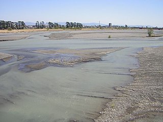
The Abe River is a river in Shizuoka Prefecture of central Japan. It is 53.3 kilometres (33.1 mi) long and has a watershed of 567 square kilometres (219 sq mi).

Limpopo is the northernmost province of South Africa. It is named after the Limpopo River, which forms the province's western and northern borders. The capital and largest city in the province is Polokwane, while the provincial legislature is situated in Lebowakgomo.
Obo is the capital of Haut-Mbomou, one of the 14 prefectures of the Central African Republic. It is close to the African Pole of Inaccessibility.

Suphan Buri is a town in central Thailand. It covers tambon Tha Philiang and parts of tambons Rua Yai and Tha Rahat, all within the Mueang Suphan Buri District. As of 2006 it had a population of 26,656. The town is 101 km north-northwest of Bangkok.

The Olifants River,Lepelle, iBhalule or Obalule is a river in South Africa and Mozambique, a tributary of the Limpopo River. It falls into the Drainage Area B of the Drainage basins of South Africa. The historical area of the Pedi people, Sekhukhuneland, is located between the Olifants River and one of its largest tributaries, the Steelpoort River.

Livingstone is a city in Zambia. Until 1935, it served as the capital city of Zambia. Lying 10 km (6.2 mi) to the north of the Zambezi River, it is a tourism attraction center for the Victoria Falls and a border town with road and rail connections to Zimbabwe on the other side of the Victoria Falls. A historic British colonial city, its present population was enumerated at 134,349 inhabitants at the 2010 census. It is named after David Livingstone, the Scottish explorer and missionary who was the first European to explore the area.

The blue-capped cordon-bleu or blue-capped cordonbleu is native to Ethiopia, Kenya, Somalia, South Sudan, and Tanzania in East Africa. This small finch does fairly well in captivity given adequate conditions; however, breeding this finch is said to be quite difficult.

Crawley is a small village in Hampshire, England. It is a few miles from the county town of Winchester. It is a civil parish within the City of Winchester local government district. The village is the location of Crawley Court, currently the headquarters of broadcast infrastructure company Arqiva.

NGC 3195 is a planetary nebula located in the southern constellation of Chamaeleon. It is the most southern of all the bright sizable planetary nebula in the sky, and remains concealed from all northern observers. Discovered by Sir John Herschel in 1835, this 11.6 apparent magnitude planetary nebula is slightly oval in shape, with dimensions of 40×35 arc seconds, and can be seen visually in telescopic apertures of 10.5 centimetres (4.1 in) at low magnifications.

The Republic of the Congo, also known as Congo-Brazzaville, the Congo Republic or simply either Congo or the Congo, is a country located on the western coast of Central Africa to the west of the Congo River. It is bordered to the west by Gabon, to its northwest by Cameroon and its northeast by the Central African Republic, to the southeast by the Democratic Republic of the Congo, to its south by the Angolan exclave of Cabinda and to its southwest by the Atlantic Ocean.
Gölbaşı Dam is a dam in Turkey. The development was backed by the Turkish State Hydraulic Works.
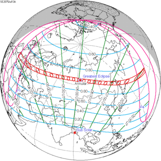
An annular solar eclipse will occur on Saturday, July 13, 2075. A solar eclipse occurs when the Moon passes between Earth and the Sun, thereby totally or partly obscuring the image of the Sun for a viewer on Earth. An annular solar eclipse occurs when the Moon's apparent diameter is smaller than the Sun's, blocking most of the Sun's light and causing the Sun to look like an annulus (ring). An annular eclipse appears as a partial eclipse over a region of the Earth thousands of kilometers wide.
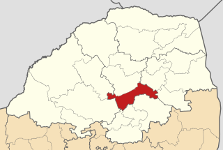
Lepelle-Nkumpi Local Municipality, is located in the Capricorn District Municipality, of Limpopo province, South Africa. The seat is Lebowakgomo.
Lebowakgomo Stadium is a multi-use stadium in Lebowakgomo, situated 60 km south of Polokwane, at the Limpopo province in South Africa. It is currently used mostly for football matches, and is the home venue of Fanang Diatla F.C. in the Vodacom League.

The South African Railways Class 34-200 of 1971 is a diesel-electric locomotive.
Schuinsrand is a town in Lepelle-Nkumpi Local Municipality in the Limpopo province of South Africa.

