
Anishinaabe traditional beliefs cover the traditional belief system of the Anishinaabeg peoples, consisting of the Algonquin/Nipissing, Ojibwa/Chippewa/Saulteaux/Mississaugas, Odawa, Potawatomi and Oji-Cree, located primarily in the Great Lakes region of North America.
Nokomis is the name of Nanabozho's grandmother in the Ojibwe traditional stories and was the name of Hiawatha's grandmother in Henry Wadsworth Longfellow's poem, The Song of Hiawatha, which is a re-telling of the Nanabozho stories. Nokomis is an important character in the poem, mentioned in the familiar lines:

Lake Nokomis is one of several lakes in Minneapolis, Minnesota, and part of the city's Chain of Lakes. The lake was previously named Lake Amelia in honor of Captain George Gooding's daughter, Amelia, in 1819. Its current name was adopted in 1910 to honor Nokomis, grandmother of Hiawatha. It is located in the southern part of the city, west of the Mississippi River and south of Lake Hiawatha. The lake is oval in shape, with a long axis running southwest to northeast. Two pathways circle the lake, a 2.7-mile (4.3 km) pedestrian trail and a 2.8-mile (4.5 km) bicycle trail. Because the lower part of the lake is crossed by Cedar Avenue running north-south, the impression from the ground is that the lake is shaped like an L. The lake has an area of 204 acres (0.83 km2).

The Grand Rounds National Scenic Byway is a linked series of park areas in Minneapolis, Minnesota, United States, that takes a roughly circular path through the city. The Minneapolis Park and Recreation Board developed the system over many years. The corridors include roads for automobile traffic plus separate paths for pedestrians and bicycles, and extend slightly into neighboring cities. About 50 miles (80 km) of roadway and paths are in the system, and much of it was built in the 1930s as part of Civilian Conservation Corps projects.

The Diamond Lake neighborhood is in the Nokomis community in Minneapolis. It is bounded by Diamond Lake Road and 55th Street on the north, Cedar Avenue on the east, 62nd Street on the south, and Interstate 35W on the west. It has approximately 2233 households within its boundaries. The Diamond Lake neighborhood, together with Hale and Page, forms the HPDL.
Morris Park may refer to:

Field is a neighborhood in the Nokomis community in south Minneapolis, Minnesota. The neighborhood is bordered by East 46th Street on the north, Chicago Avenue on the east, Minnehaha Parkway on the south, and Interstate 35W on the west. Field shares a neighborhood organization with the Regina and Northrop neighborhoods.

Bancroft is a neighborhood within the Powderhorn community in Minneapolis, Minnesota, United States. Its boundaries are East 38th Street to the north, Chicago Avenue to the west, East 42nd Street to the south and Cedar Avenue to the east.

Nokomis is a community in Minneapolis, Minnesota. It takes its name from Lake Nokomis. It comprises eleven smaller neighborhoods.
Standish is a neighborhood within the Powderhorn community in Minneapolis, Minnesota, United States named after Captain Miles Standish. Its boundaries are East 36th Street to the north, Hiawatha Avenue to the east, East 42nd and 43rd Streets to the south, and Cedar Avenue to the west. It shares a neighborhood organization with the Ericsson neighborhood, even though that neighborhood is part of the Nokomis community; signs at the neighborhood boundaries welcome you to "Standish-Ericsson". Roosevelt High School is located in Standish.

Ericsson is a neighborhood within the Nokomis community in Minneapolis. Its boundaries are East 42nd and 43rd Streets to the north, Hiawatha Avenue to the east, Minnehaha Parkway to the south, and Cedar Avenue to the west. The neighborhood is the site of Lake Hiawatha, which is connected to Minnehaha Creek. Ericsson shares a neighborhood organization with Standish, even though that neighborhood lies in the Powderhorn community; signs at the western, southern, and eastern boundaries of the neighborhood welcome you to "Standish-Ericsson".

Nokomis Library, formerly Nokomis Community Library, is a branch library serving the Nokomis East area of Minneapolis, Minnesota. One of 41 libraries in the Hennepin County Library system, Nokomis was designed by Buetow and Associates, Inc and opened in 1968 as a replacement for the nearby Longfellow Community Library. After being deemed crowded and outdated in 1999, the library underwent a renovation beginning in 2009 that saw it gain a number of environmentally friendly features and an expansion of 4,300 square feet (399 m2). The building reopened in 2011 and includes a restored Wind and Water Chime, a stabile that was part of the original library and that was refurbished and reinstalled by July 2013. The library contains over 35 computers, a public meeting room, and a Spanish-language collection of materials.

Regina is a neighborhood within the Nokomis community in Minneapolis, Minnesota. Its boundaries are 42nd Street to the north, Chicago Avenue to the east, 46th Street to the south, and Interstate 35W to the west. It shares a neighborhood organization with the Field and Northrop neighborhoods.
Northrop is a neighborhood located in the Nokomis community in Minneapolis, Minnesota, United States. The neighborhood is bordered by 42nd Street to the north, Cedar Avenue to the east, Minnehaha Parkway to the south, and Chicago Avenue to the west. Northrop shares a neighborhood organization with the Field and Regina neighborhoods.

Keewaydin is a neighborhood in the Nokomis community in Minneapolis, Minnesota. Its boundaries are Minnehaha Parkway to the north, 34th Avenue to the east, 54th Street to the south, and Cedar Avenue to the west. The neighborhood contains the majority of Lake Nokomis. It shares a neighborhood organization with the Minnehaha, Morris Park, and Wenonah neighborhoods, which are collectively referred to as Nokomis East and served by the Nokomis East Neighborhood Association (NENA).
Minnehaha is a neighborhood in the Nokomis community in Minneapolis, Minnesota. Its boundaries are Minnehaha Parkway to the north, Hiawatha Avenue to the east, 54th Street to the south, and 34th Avenue to the west. It shares a neighborhood organization with the Keewaydin, Morris Park, and Wenonah neighborhoods, which are collectively referred to as Nokomis East and served by the Nokomis East Neighborhood Association (NENA).

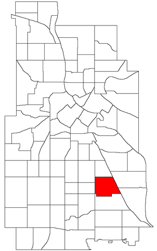
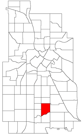
Morris Park is a neighborhood in the Nokomis community in Minneapolis, Minnesota. Its boundaries are 54th Street to the north, 46th Avenue to the east, the Twin Cities Air Force Base to the south, and 34th Avenue to the west. It shares a neighborhood organization with the Keewaydin, Minnehaha, and Wenonah neighborhoods, which are collectively referred to as Nokomis East and served by the Nokomis East Neighborhood Association (NENA).
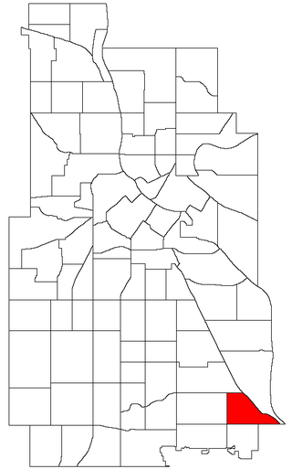
Wenonah is a neighborhood on the southeast side of Minneapolis, Minnesota. Its boundaries are 54th Street to the north, 34th Avenue to the east, the Minneapolis-Saint Paul International Airport to the south, and Cedar Avenue to the west. The neighborhood contains a portion of Lake Nokomis. It shares a neighborhood organization with the Keewaydin, Minnehaha, and Morris Park neighborhoods, which are collectively referred to as Nokomis East and are served by the Nokomis East Neighborhood Association (NENA).

Nokomis East is a group of neighborhoods in the southeastern corner of Minneapolis, Minnesota, United States. It consists of four neighborhoods: Keewaydin, Minnehaha, Morris Park and Wenonah. Nokomis East contains two schools, the Nokomis Community Library, and a post office. On its western edge is Lake Nokomis, for which it is named. Two regional parks, and three neighborhood parks, provide recreation and educational programming for all age groups. Seven churches serve residents of various denominations. Nokomis East is served by the Nokomis East Neighborhood Association (NENA). The main transportation corridors are the neighborhood boundaries: Cedar Avenue, 34th and 28th Avenues, 50th and 54th Streets, Hwy 55, and Crosstown highway 62.
USS Nokomis may refer to: