
North Holland is a province of the Netherlands located in the northwestern part of the country. It is situated on the North Sea, north of South Holland and Utrecht, and west of Friesland and Flevoland. In 2015, it had a population of 2,762,163 and a total area of 2,670 km2 (1,030 sq mi).

Noord-Scharwoude is a Dutch village in the municipality of Langedijk.
Pijnacker is a town in the Dutch province of South Holland. It is located about 4 km east of the city of Delft, in the municipality of Pijnacker-Nootdorp.
Zevenbergen is a Dutch city which is a part of the municipality of Moerdijk. Zevenbergen is located in the northwest of the province of Noord-Brabant near Breda.

Polsbroek is a village in the Dutch province of Utrecht. It is a part of the municipality of Lopik, and lies about 10 km southeast of Gouda. The village of Polsbroek consists of a ribbon of farms on both sides of the Benschopse Wetering, with a small centre on the west side of the village.

Ransdorp is a village in the province of North Holland, Netherlands, part of the municipality of Amsterdam. It lies about 7 km northeast of the city centre, in the Landelijk Noord district. Ransdorp is a part of the borough Amsterdam-Noord and has about 245 inhabitants.

Amsterdam-Noord is a borough of Amsterdam, Netherlands with a population of about 90,000. The IJ, the body of water which separates it from Amsterdam-Centrum and the rest of the city, is situated southwest of Amsterdam-Noord. The borough, which has an area of 49.01 km2, borders the municipalities of Zaanstad, Oostzaan, Landsmeer and Waterland to the north, all part of the province of North Holland like Amsterdam. It borders the Markermeer to the east.
's-Gravenhoek is a former municipality in the Dutch province of Zeeland. It consisted of a number of polders on the north side of the island of Noord-Beveland, east of Wissenkerke.
Kampensnieuwland or Kampernieuwland is a former municipality in the Dutch province of Zeeland. It existed until 1816, when it merged into the municipality of Wissenkerke.
Buiksloot is a former village in the Dutch province of North Holland. It is now a neighbourhood of Amsterdam-Noord.
Oudkarspel is a village in the Dutch province of North Holland. It is located in the municipality of Langedijk, north of the town of Noord-Scharwoude.
Zuid- en Noord-Schermer is a former municipality in the Dutch province of North Holland. It existed until 1970, when it became a part of the municipality of Schermer.

Herveld is a village in the Dutch province of Gelderland. It is located in the municipality of Overbetuwe.
Budel is a village in the Dutch province of Noord Brabant. It is located in the municipality of Cranendonck, 25 km outside Eindhoven. Kempen Airport is located near Budel.
Noord-Waddinxveen is a former municipality in the Dutch province of South Holland. It covered the northern half of the village Waddinxveen.
Zuid-Waddinxveen is a former municipality in the Dutch province of South Holland. It covered the southern half of the village Waddinxveen.
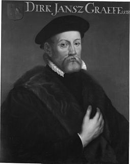
Diederik Jansz Graeff, also Dirk Jansz Graeff, Lord of the manor Vredenhof, first illustrious member of the De Graeff family, was a rich merchant, ship-owner and politician. Diederik Graeff was also the founder of a regent dynastie of the Dutch Golden Age and the short time of the First Stadtholderless Period that retained power and influence for centuries and produced a number of ministers. He was the first Mayor of Amsterdam from the De Graeff family.
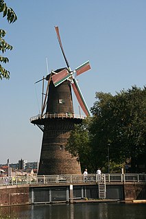
De Noord is a windmill located on the Noordvest 38 in Schiedam, Netherlands. It is the tallest windmill in the world with a roof height of 33.3 metres. Its wing span is 26.6 metres. The mill is one of the five remaining windmills in Schiedam, and is a national monument since 29 May 1969. Today De Noord houses a restaurant.
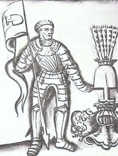
Wolfgang von Graben, also Wolfgang de Groben and Wolfgang Grabenski was born in Kornberg castle, Styria and a member of the Austrian nobility. He held the titles as a Lord of Graben, Kornberg, Marburg, Obermarburg, Radkersburg and Viscount of Saldenhofen.


