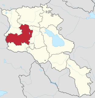
Aragatsotn is a province (marz) of Armenia. It is located in the western part of the country. The capital and largest city of the province is the town of Ashtarak. The National Statistical Service of the Republic of Armenia (ARMSTAT) reported its population was 132,925 in the 2011 census.
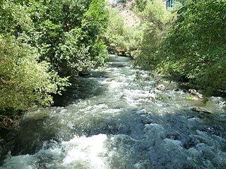
Kasagh is a river in the west-central region of modern Armenia which flows north to south. It originates near Mount Aragats in Aragatsotn province, flows south into Armavir province and into the Metsamor River, which itself is a tributary of the Aras River.
The Red Bluff First Nation is a Dakelh First Nations government located in the northern Fraser Canyon region of the Canadian province of British Columbia. It is a member of the Carrier-Chilcotin Tribal Council, which includes both Tsilhqot'in and Carrier (Dakelh) communities.

Altena is a village in the northeastern Netherlands. It is located in the municipality of Noordenveld, Drenthe, 2 km southwest of Peize. It has an altitude of 2 meters (9 feet).

Kasagh, is a major village in the Kotayk Province of Armenia.
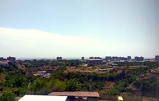
Ajapnyak, is one of the 12 districts of Yerevan, the capital of Armenia. Located to the northwest of the city centre, Ajapnyak has common borders with the districts of Arabkir from the east, Davtashen from the north, Kentron from the southeast, and Malatia-Sebastia from the south. Hrazdan River forms the natural border of the district from the east. Ajapnyak has also common borders with the provinces of Armavir and Aragatsotn from the west, and Kotayk from the north.
Kasagh, is an abandoned village in the Aragatsotn Province of Armenia. It was abandoned in 1965 and its ruins now lie beneath the Aparan Reservoir.

Mughni is a village in the Aragatsotn Province of Armenia. It is located just to the north of Ashtarak town and belongs to its municipality. Until the Russian conquest, it was the southernmost town in the district of Aparan. Mughni is home to the 14th-century Saint Gevork Monastery, which was formerly a popular pilgrimage site and the seat of an archbishop. The dome of the church was rebuilt in the 1660s.

Chalno-Parcele is a village in the administrative district of Gmina Topólka, within Radziejów County, Kuyavian-Pomeranian Voivodeship, in north-central Poland. It lies approximately 6 kilometres (4 mi) south-west of Topólka, 20 km (12 mi) south-east of Radziejów, and 62 km (39 mi) south of Toruń.

Köhünlü is a village and municipality in the Kurdamir Rayon of Azerbaijan.
Tanibórz is a village in the administrative district of Gmina Kleszczewo, within Poznań County, Greater Poland Voivodeship, in west-central Poland. It lies approximately 16 km (10 mi) east of the regional capital Poznań.
Góry is a village in the administrative district of Gmina Wilczęta, within Braniewo County, Warmian-Masurian Voivodeship, in northern Poland. It lies approximately 10 kilometres (6 mi) west of Wilczęta, 29 km (18 mi) south of Braniewo, and 63 km (39 mi) north-west of the regional capital Olsztyn.
Orzechowo is a village in the administrative district of Gmina Nowogard, within Goleniów County, West Pomeranian Voivodeship, in north-western Poland. It lies approximately 9 kilometres (6 mi) north of Nowogard, 30 km (19 mi) north-east of Goleniów, and 52 km (32 mi) north-east of the regional capital Szczecin.

Cuilidh is the second music album by Scottish musician Julie Fowlis, which in 2008 won her the Album of the Year Award at the Scots Trad Music Awards and Best Folk Singer Award at the BBC Radio 2 Folk Music Awards.
Jiuru Township is a rural township in Pingtung County, Taiwan.
Qinbei District is a district of the city of Qinzhou, Guangxi, China.

Kolan is a settlement and municipality in Zadar County, Croatia.According to 2011 census information, there are 791 inhabitants of Kolan.

Garegin Nzhdeh Square, formerly Souren Spandaryan Square, is the 2nd largest square in the city of Yerevan, Armenia. It is located in the Shengavit district, to the south of the city centre. The square is intersected by the following streets: Garegin Nzhdeh, Manandian, Yeghbayrutian and Bagratuniats. The square was officially opened on 30 April 1959.

Stadio Olimpico del Ghiaccio was built between 1952 and 1954, primarily as an open air Figure skating arena in Cortina d'Ampezzo, Italy, to hold between seven and eight thousand spectators, with the possibility of making temporary arrangements to accommodate twelve to fifteen thousand for the period of the Olympics. The venue was inaugurated on 26 October 1955. During the 1956 Winter Olympics, the arena held the opening and closing ceremonies, the figure skating events and select ice hockey games. Sometime after 1981, a roof was added to the structure. The stadium will host curling if Milan/Cortina d'Ampezzo is awarded the 2026 Winter Olympics.


