
Elkridge is an unincorporated community and census-designated place (CDP) in Howard County, Maryland, United States. The population was 15,593 at the 2010 census. Founded early in the 18th century, Elkridge is located at the confluence of three counties, the other two being Anne Arundel and Baltimore counties.

North Potomac is a census-designated place and unincorporated area in Montgomery County, Maryland, United States. It is located less than 5 miles (8.0 km) north of the Potomac River, and is about 20 miles (32 km) from Washington, D.C. It has a population of 23,790 as of 2020.

Laurel is a city in Maryland, United States, located midway between Washington and Baltimore on the banks of the Patuxent River. While the city limits are entirely in northern Prince George's County, outlying developments extend into Anne Arundel, Montgomery and Howard counties. Founded as a mill town in the early 19th century, Laurel expanded local industry and was later able to become an early commuter town for Washington and Baltimore workers following the arrival of the Baltimore and Ohio Railroad in 1835. Largely residential today, the city maintains a historic district centered on its Main Street, highlighting its industrial past.

Muirkirk is an unincorporated community in northern Prince George's County, Maryland, United States, located between Baltimore and Washington in the central part of the state.

The Maryland-National Capital Park and Planning Commission (M-NCPPC) is a bi-county agency that administers parks and planning in Montgomery and Prince George's counties in Maryland.

Derwood is an unincorporated area and census-designated place in east-central Montgomery County, Maryland, United States. It lies just north of Rockville, southeast of Gaithersburg, southwest of Olney, and northwest of the greater Silver Spring area. Derwood, originally "Deer Park", then "Deer Wood," is home to approximately 15,600 people.
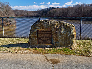
Lake Bernard Frank, is a 54-acre (220,000 m2) reservoir on the North Branch of Rock Creek in Derwood, Maryland, U.S., just east of Rockville. In the late 1960s it was renamed after Bernard Frank, a wilderness activist and a co-founder of The Wilderness Society. The lake's boundaries are, approximately, Route 28, East Gude Drive, Avery Road, and Muncaster Mill Road. Lake Frank was created in 1966 as Lake Norbeck to aid in flood and sediment control, as well as to provide recreation. It has an earthen dam, installed in 1967, on its southern side. It was created as a sister lake to Lake Needwood. Lake Frank is owned by the Maryland-National Capital Park and Planning Commission (M–NCPPC).
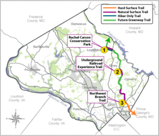
The Rachel Carson Greenway is a planned 25-mile stretch of trails, spanning from the historic Adelphi Mill in Prince George's County north through eastern Montgomery County, Maryland to Patuxent River State Park, and incorporating existing Northwest Branch trails. The greenway was proposed as part of a 1998 Countywide Park Trails Plan. A plan for the greenway was approved by the Montgomery County Planning Board on June 15, 2005.
Norbeck is the area of Montgomery County, Maryland, United States, around Norbeck Road east of Georgia Avenue to Layhill Road. Shortly before the Civil War, free blacks founded Norbeck.

Acorn Park is a 0.1247-acre (0.050-hectare) urban park in downtown Silver Spring, Maryland, which features an acorn-shaped gazebo and an artificial grotto. The site is historically significant as it is thought to be the location of the "mica-flecked spring" that in 1840 inspired Francis Preston Blair to name his estate "Silver Spring".

The Adelphi Mill is the only surviving historic mill in Prince George's County, Maryland. It is the oldest and largest mill in the Washington, D.C. area.

Maryland Route 115 is a state highway in the U.S. state of Maryland. Known as Muncaster Mill Road, the highway runs 5.83 miles (9.38 km) from MD 124 near Redland east to MD 655 at Norbeck. MD 115 is a northwest–southeast highway that connects the suburban communities of Redland and Norbeck in central Montgomery County. The highway was constructed from MD 124 to MD 28 in the late 1920s and early 1930s.
Aquasco is an unincorporated area and census-designated place in southeastern Prince George's County, Maryland, United States, surrounding the town of Eagle Harbor and bordering Charles County. As of the 2010 census, the CDP had a population of 981. Aquasco was home to the Aquasco Speedway.
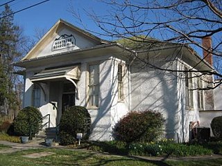
The Montrose School House is a historic school building located in Montgomery County, Maryland, in North Bethesda, south of the city of Rockville. It is a one-story, rectangular, hip-roofed building of frame construction with a pebble-dash finish. It is the best-preserved of the six functional school buildings constructed in Montgomery County around 1910.

Northwest Branch Anacostia River is a 21.5-mile-long (34.6 km) free-flowing stream in Montgomery County and Prince George's County, Maryland. It is a tributary of the Anacostia River, which flows to the Potomac River and the Chesapeake Bay.
The Anacostia Tributary Trail System (ATTS) is a unified and signed system of stream valley trails joining trails along the Anacostia tributaries of Northwest Branch, Northeast Branch, Indian Creek and Paint Branch with a trail along the Anacostia River, set aside and maintained by the Maryland-National Capital Park and Planning Commission (M-NCPPC) in the Maryland suburbs of Washington, D.C.
Four Corners is a neighborhood located in Montgomery County, Maryland, United States. Many residents of Four Corners consider the neighborhood to be a part of Silver Spring. The United States Census Bureau defines Four Corners as a distinct census-designated place (CDP). Prior to 2010, it was defined as a part of the Silver Spring CDP. Four Corners has a population of 8,316 as of the 2020 census.

Wheaton Regional Park is a public park and county-designated protected area, located in Wheaton, Maryland. It is operated and managed by Montgomery County Parks, a division of a bi-county agency, Maryland-National Capital Park and Planning Commission (M–NCPPC), which serves both Montgomery and Prince George's counties in the Washington, D.C. suburbs of the state of Maryland. The park was established in 1960, incorporating several large parcels of land into one of the county's largest parks, at the size of 538.7 acres.

The Rock Creek Trails are a series of trails through the Rock Creek valley and along the Potomac River in Washington, DC and Montgomery County, MD. The main route extends 22 miles from Lake Needwood in Maryland to the Inlet Bridge in Washington, DC, with a loop in the north part of Rock Creek Park and other trails through the Klingle Valley, Turkey Branch Valley and along the North Branch of Rock Creek. There are three separate trails that make up the main Rock Creek Trail route and others that connect to it. Along the Potomac River from Arlington Memorial Bridge to Rock Creek is a section sometimes called the Shoreline Trail.

Forest Glen Park is an unincorporated community in Montgomery County, Maryland and a residential neighborhood within the Silver Spring census-designated place. The community is adjacent to Rock Creek, Rock Creek Regional Park, and to the United States Army's Forest Glen Annex.