St. John the Baptist Parish is a parish located in the U.S. state of Louisiana. At the 2020 census, the population was 42,477. The parish seat is Edgard, an unincorporated area, and the largest city is LaPlace, which is also unincorporated.

Concordia Parish is a parish that borders the Mississippi River in eastern central Louisiana. As of the 2020 census, the population was 18,687. The parish seat is Vidalia. The parish was formed in 1807.

Natchez, officially the City of Natchez, is the only city in and the county seat of Adams County, Mississippi, United States. The population was 14,520 at the 2020 census. Located on the Mississippi River across from Vidalia in Concordia Parish, Louisiana, Natchez was a prominent city in the antebellum years, a center of cotton planters and Mississippi River trade.
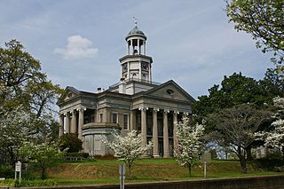
Vicksburg is a historic city in Warren County, Mississippi, United States. It is the county seat. The population was 21,573 at the 2020 census. Located on a high bluff on the east bank of the Mississippi River across from Louisiana, Vicksburg was built by French colonists in 1719. The outpost withstood an attack from the native Natchez people. It was incorporated as Vicksburg in 1825 after Methodist missionary Newitt Vick. The area that is now Vicksburg was long occupied by the Natchez Native Americans as part of their historical territory along the Mississippi. The first Europeans who settled the area were French colonists who built Fort Saint Pierre in 1719 on the high bluffs overlooking the Yazoo River at present-day Redwood. They conducted fur trading with the Natchez and others, and started plantations. During the American Civil War, it was a key Confederate river-port, and its July 1863 surrender to Ulysses S. Grant, along with the concurrent Battle of Gettysburg, marked the turning-point of the war.
The Natchez District was one of two areas established in the Kingdom of Great Britain's West Florida colony during the 1770s – the other being the Tombigbee District. The first Anglo settlers in the district came primarily from other parts of British America. The district was recognized to be the area east of the Mississippi River from Bayou Sara in the south and Bayou Pierre in the north.

The history of the state of Mississippi extends back to thousands of years of indigenous peoples. Evidence of their cultures has been found largely through archeological excavations, as well as existing remains of earthwork mounds built thousands of years ago. Native American traditions were kept through oral histories; with Europeans recording the accounts of historic peoples they encountered. Since the late 20th century, there have been increased studies of the Native American tribes and reliance on their oral histories to document their cultures. Their accounts have been correlated with evidence of natural events.
Isaac Franklin was an American slave trader and plantation owner. Born to wealthy planters in what would become Sumner County, Tennessee, he assisted his brothers in trading slaves and agricultural surplus along the Mississippi River in his youth, before briefly serving in the Tennessee militia during the War of 1812. He returned to slave trading soon after the war, buying enslaved people in Virginia and Maryland, before marching them in coffles to sale at Natchez, Mississippi. He introduced John Armfield to the slave trade, and with him founded the Franklin & Armfield partnership in 1828, which would go on to become one of the largest slave trading firms in the United States. With a base of operations in Alexandria, D.C., the company shipped massive numbers of the enslaved by land and sea to markets at Natchez and New Orleans.
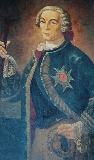
Étienne Perier or Étienne de Perier (1686–1766), also known as Perier the Elder, was a French naval officer and governor of French Louisiana from 1726 to 1733. His time as governor included some notable achievements, including the construction of the first levee along the Mississippi River in 1727. In response to the Natchez Revolt, he attempted to completely destroy the Natchez people, which increased Native American hostility toward the French in the territory. Because he failed to secure the safety of the colony, Perier was recalled as governor in March 1733. He later distinguished himself as a naval officer and privateer, including during the capture of HMS Northumberland in 1744.
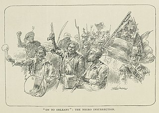
The 1811 German Coast uprising was a slave rebellion which occurred in the Territory of Orleans from January 8–10, 1811. It occurred on the east bank of the Mississippi River in the modern-day Louisiana parishes of St. John the Baptist, St. Charles and Jefferson. The rebellion was the largest of its kind in the history of the United States, but the rebels only killed two white men. Confrontations with U.S. military personnel and local militiamen who were sent to suppress the rebellion, combined with post-trial executions, resulted in the deaths of 95 rebels.

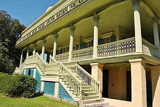
Plantation complexes were common on agricultural plantations in the Southern United States from the 17th into the 20th century. The complex included everything from the main residence down to the pens for livestock. Until the abolition of slavery, such plantations were generally self-sufficient settlements that relied on the forced labor of enslaved people.
The Chaouacha were an Indigenous people of Louisiana. They were likely related to the Chitimacha.

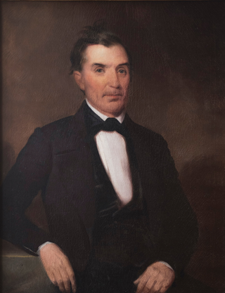
Stephen Duncan was an American planter and banker in Mississippi. He was born and studied medicine in Pennsylvania, but moved to Natchez District, Mississippi Territory in 1808 and became the wealthiest cotton planter and the second-largest slave owner in the United States with over 2,200 slaves. He owned 15 cotton and sugar plantations, served as President of the Bank of Mississippi, and held major investments in railroads and lumber.

David Hunt was an American planter based in the Natchez District of Mississippi. From New Jersey in approximately 1800, he took a job in his uncle Abijah Hunt's Mississippi business. After his uncle's untimely 1811 death, as a benefeciary and as the executor of the estate, he began to convert the estate into his plantation empire. By the time of the 1860 slave census, Hunt owned close to 800 slaves. This was after ensuring that each of his five adult children had at least one plantation and had an approximate minimum of 100 slaves apiece. In fact, Hunt and his five adult children and their spouses owned some 1,700 slaves by 1860. He became a major philanthropist in the South, contributing to educational institutions in Mississippi, as well as the American Colonization Society and Mississippi Colonization Society, the latter of which he was a founding member.

Abijah Hunt (1762–1811) was an American merchant, planter, slave trader, and banker in the Natchez District.
Following Robert Cavelier de La Salle establishing the French claim to the territory and the introduction of the name Louisiana, the first settlements in the southernmost portion of Louisiana were developed at present-day Biloxi (1699), Mobile (1702), Natchitoches (1714), and New Orleans (1718). Slavery was then established by European colonists.
The city of Natchez, Mississippi, was founded in 1716 as Fort Rosalie, and renamed for the Natchez people in 1763.
The Norman Studio in photography refers to the family business run principally by photographers Henry C. Norman (1850—1913) and his son Earl Norman (1888—1951) in Natchez, Mississippi between 1876 and 1951, which produced around 75,000 images documenting many significant types of events and subjects in the various small towns along the lower Mississippi River. Its output remains one of the most valuable and comprehensive visual collections documenting Southern American life during the late nineteenth and early twentieth centuries.
Marie Adrien Persac (1823–1873) was a French-born American fine art painter, cartographer, photographer, and art teacher. Persac watercolored south Louisiana plantation houses and other aspects of the Southern landscape, and his work has much importance to Southern historians. His work was often signed, A. Persac.

Pierre Michel La Pice de Bergondy, generally known as P. M. Lapice, sometimes Peter Lapice, was a merchant, sugar planter, and owner of a large number of slaves in 19th-century Mississippi and Louisiana in the United States. He was credited with Louisiana sugar-industry firsts, including producing the first white sugar, erecting the first cane-mill with five rollers, and building the first successful bagasse burner.

