Related Research Articles

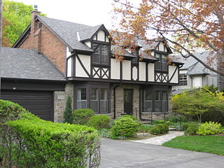
Forest Hill is a neighbourhood and former village in Midtown Toronto, Ontario, Canada, located north of Downtown Toronto. The village was amalgamated into Toronto in 1967 and the area has retained its name as a neighbourhood. Along with other neighbourhoods such as Rosedale, and The Bridle Path, it is one of Toronto's wealthiest and most affluent neighbourhoods. It is home to many prominent entrepreneurs, celebrities, engineers, doctors, and lawyers. Census data from Statistics Canada states an average income for all private households in Forest Hill to be $101,631, compared to the $40,704 average income in Toronto's Census Metropolitan Area.

Regina Walsh Acres is a provincial electoral district for the Legislative Assembly of Saskatchewan, Canada. Originally created for the 16th Saskatchewan general election in 1967 from parts of Regina North and Regina West, this constituency has changed boundaries many times.

Le Plateau-Mont-Royal is a borough (arrondissement) of the city of Montreal, Quebec, Canada.

Shaughnessy is an almost-entirely residential neighbourhood in Vancouver, British Columbia, Canada, spanning about 447 hectares in a relatively central locale. It is bordered by 16th Avenue to the north, 41st Avenue to the south, Oak Street to the east, and East Boulevard to the west. The older section of the neighbourhood, called "First Shaughnessy," is considered more prestigious and is bordered by 16th Avenue to the north, King Edward Avenue to the south, Oak Street to the east, and East Boulevard to the west. In 2011, the population was approximately 8,807. It was named after Thomas Shaughnessy, 1st Baron Shaughnessy, former president of the Canadian Pacific Railway.
Humber Valley Village is a neighbourhood located in Toronto, Ontario, Canada. It is within the former City of Etobicoke and includes some of the most expensive real estate in the metropolitan west end. The boundaries are from Dundas Street on the south to Islington Avenue to the west, Eglinton Avenue to the north, and the Humber River in the east. The neighbourhood is in the political riding of Etobicoke Centre.

Humewood–Cedarvale is an area of Toronto, Ontario, Canada, consisting of the lower middle class to wealthy Cedarvale in the north and the lower to upper middle class Humewood in the south, divided by Vaughan Road and Cedarvale Ravine. The neighbourhood is bordered by Bathurst Street on the east, Eglinton Avenue to the north, Arlington Avenue to the west, and St. Clair Avenue to the south. Humewood has also been known as "the Woods" because of its many streets that have names ending with "-wood", including Wychwood, Humewood, Cherrywood, Valewood, Maplewood, Wellwood, Kenwood, and Pinewood. The neighbourhood's main commercial areas are along St. Clair Ave. W., referred to as Hillcrest Village and along Eglinton Ave. W..
Fairbank is a neighbourhood in Toronto, Ontario, Canada. The area covers a large central portion of the former City of York, Ontario centered on the intersection of Dufferin Street and Eglinton Avenue West. Fairbank includes the neighbourhoods of Briar Hill–Belgravia and Caledonia–Fairbank. The western border is the CNR lines. The northern and southern borders are the former borders of the City of York and the eastern border is Dufferin Street (Oakwood–Vaughan).

Alberta Avenue is a pre–World War II neighbourhood in Edmonton, Alberta, Canada.
Morningside Heights is a residential neighbourhood in the district of Scarborough in Toronto, Ontario, Canada. It is located in the northeast corner of the city, just north of the Malvern and west of Rouge Park and the Rouge. The subdivision, comprising approximately 750 acres (3.0 km2), was one of the last large tracts of undeveloped land within the City of Toronto, located between Finch Avenue East and Steeles Avenue East, from Tapscott Road to the Rouge River.

Mayfair is a neighbourhood in the city of Saskatoon, Saskatchewan, Canada. Mayfair started out as a community outside of the villages of Riversdale, Nutana and Saskatoon and appears as its own place name on a map of 1907. In 1909 there were 60 residences built in Mayfair, and in 1911, the City of Saskatoon had grown large enough to encompass Mayfair. Homeownership amongst the residents is at 68.2%.

Seven neighbourhoods are of considerable note:
McCauley is a vibrant and ethnically diverse inner city neighbourhood in Edmonton, Alberta undergoing revitalization. It is named for Matthew McCauley, the first mayor of Edmonton, and is located just to the north east of the Downtown core. McCauley is famous as the home of dozens of religious buildings concentrated in a small area as well as being a large venue for the 1978 Commonwealth Games.

Dickinsfield is a residential area in northeast Edmonton, Alberta, Canada that consists of the neighbourhoods of Evansdale and Northmount.
Sweet Grass is a residential neighbourhood in south west Edmonton, Alberta, Canada. It is named for Cree Chief Sweet Grass, "who was one of the early west's first conservationists and instrumental in the protection of the Plains Bison."
Highlands is a residential neighbourhood in north east Edmonton, Alberta, Canada overlooking the North Saskatchewan River valley. The area was annexed by Edmonton in 1912, and "was named in a contest offering a 50-dollar prize." In 2012, Highlands was ranked one of Canada's top ten neighbourhoods of old homes by the magazine This Old House.
Upper Paradise Road is an Upper City (mountain) collector road in Hamilton, Ontario, Canada. It starts off just north of Scenic Drive by Cliffview Park and extends southward where it ends just south of Rymal Road beside Carpenter Park. It is a two-way street throughout.

Martin Collegiate, also known as Martin Collegiate Institute or MCI, is a high school located in the Rosemont/Mount Royal neighbourhood in the north end of Regina, Saskatchewan, Canada. A part of Regina Public Schools, it is a designated community school, and currently has a student body population of approximately 750.

Winston Knoll Collegiate (WKC) is a public high school located in the Walsh Acres neighbourhood of northwestern Regina, Saskatchewan, Canada. A part of Regina Public Schools, it first opened its doors in 1996, to alleviate the congestion at Thom Collegiate and currently serves a community of just over 1100 students. The school operates based on a college system, which separates students based on their grade and allots them a specific group of teachers and classrooms. A strong emphasis on technology is also encouraged.

Lakeview Area is historically defined as the area bordered by Montague Street (west), Albert Street (east), 25th Avenue (south) and Regina Avenue (north) located in the south end of Regina, Saskatchewan. Over the years the borders have extended north to include residents beyond Regina Avenue and as far west as Lewvan drive, referred to as "New Lakeview."
References
- ↑ "Archived copy" (PDF). Archived from the original (PDF) on 2014-11-06. Retrieved 2013-08-18.CS1 maint: archived copy as title (link)
- ↑ http://www.regina.ca/opencms/export/sites/regina.ca/residents/urban-planning/.media/pdf/normanview-west_demog_snapshot.pdf%5B%5D