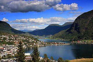
Kaupanger is a village situated along the northern shore of the Sognefjorden in the municipality of Sogndal in Sogn og Fjordane county, Norway. It sits along the Norwegian National Road 5, about 12 kilometres (7.5 mi) southeast of the municipal centre of Sogndalsfjøra and about 8 kilometres (5.0 mi) northeast of the Sogndal Airport, Haukåsen. Kaupanger IL is a sports club located in Kaupanger. The 0.87-square-kilometre (210-acre) village has a population (2013) of 931, giving the village a population density of 1,135 inhabitants per square kilometre (2,940/sq mi).

Fimreite is a small village in the municipality of Sogndal in Sogn og Fjordane county, Norway. The village sits on the south side of the mouth of the Sogndalsfjorden, where it empties into the main Sognefjorden. It is located near the end of a peninsula about 22 kilometres (14 mi) southwest of the village of Sogndalsfjøra and about 18 kilometres (11 mi) southwest of the village of Kaupanger. The village of Nornes lies across the Sogndalsfjorden from Fimreite.

Kjørnes is a small village area in the municipality of Sogndal in Sogn og Fjordane county, Norway. It is located at the inner part of the Sogndalsfjorden, about 3.5 kilometres (2.2 mi) southeast of the municipal center of Sogndalsfjøra and about 6.5 kilometres (4.0 mi) northwest of the village of Kaupanger. Kjørnes is a suburb or bedroom community for the village of Sogndalsfjøra. The village area sits along Norwegian National Road 5 on the steep, forested, hill leading down to the shore of the fjord.

Sogndalsfjøra is the administrative center of the municipality of Sogndal in Sogn og Fjordane county, Norway. It is located where the river Sogndalselvi runs out in the Sogndalsfjorden, a branch of the large Sognefjorden. The village is located about 3.5 kilometres (2.2 mi) northwest of the village of Kjørnes, about 10 kilometres (6.2 mi) northwest of the village of Kaupanger, and about 31 kilometres (19 mi) southeast of the village of Fjærland.

Vevring is a former municipality in Sogn og Fjordane county, Norway. The municipality existed from 1838 until its dissolution in 1964. It encompassed the land surrounding the western part of the Førdefjorden on both the north and south shores of the fjord. It stretched from the Ålasundet strait in the east to the mouth of the fjord in the west and from the Steindalen valley in the north to the mountains south of the fjord. The municipality was 120 square kilometres (46 sq mi) in 1964 when it was dissolved.

Eikefjord is a former municipality in the Sunnfjord district in Sogn og Fjordane county, Norway. The 145-square-kilometre (56 sq mi) municipality existed from 1923 until 1964 when it joined the present-day Flora Municipality. The administrative center of the former municipality was the village of Eikefjord, where Eikefjord Church is located. The municipality of Eikefjord was located at the end of the Eikefjorden, about 30 kilometres (19 mi) east of the town of Florø. The lake Endestadvatnet was part of the municipality. The municipality encompassed the immediate area around the village of Eikefjord and to the east and south of the village.

Fjærland is region in the municipality of Sogndal, at the end of the Fjærlandsfjorden, in Sogn og Fjordane county, Norway. The Fjærlandfjorden is a branch going north off the Sognefjorden, the longest fjord in Norway. The primary development in the region is the village Mundal located about 31 kilometres (19 mi) northwest of the municipal center of Sogndalsfjøra, along the Norwegian National Road 5. The region encompasses rich farming country, including the areas of Bøyum and Oygard.
Sogndal, Sokndal, or Soknedal are similarly sounding Norwegian place names. They may refer to:

Vangsnes is a village located in the municipality of Vik in Sogn og Fjordane county, Norway. It's located on a relatively flat and fertile peninsula that juts out on the south side of the Sognefjorden, roughly at the midpoint of the fjord which is Norway's longest. The village of Balestrand lies about 7 kilometres (4.3 mi) to the northwest and the villages of Leikanger-Hermansverk lie about 11 kilometres (6.8 mi) straight east. Vangsnes Church is located in the village.

Hermansverk or Leikanger is a large village in the municipality of Leikanger in Sogn og Fjordane county, Norway. The village serves as the administrative centre of both the municipality of Leikanger and also Sogn og Fjordane county.

Sogn og Fjordane County Municipality is the regional governing administration for Sogn og Fjordane county in Norway. The main responsibilities of the county municipality includes the running of 12 upper secondary schools with 4,500 pupils. It also administrates the county roadways, public transport, dental care, culture, and cultural heritage.
Fjærlandsfjorden is a fjord in Sogn og Fjordane county, Norway. It is a fjord arm that branches off the main Sognefjorden to the north, running through the municipalities of Balestrand, Leikanger, and Sogndal. The 25-kilometre (16 mi) long fjord begins at the village of Fjærland in Sogndal, flowing to the south until it joins the Sognefjorden near the village of Balestrand. The Esefjorden and Vetlefjorden are two small fjord arms that branch off the Fjærdlandsfjorden. The fjord is about 1.5 kilometres (0.93 mi) wide, with steep mountains on both sides of the fjord. The head of the fjord is the only habitable area around the fjord. It is a flat river valley extending north of the fjord. The inner part of the fjord where the village of Fjærland is located is only accessible by boat or via long road tunnels through the surrounding mountains. The western end of the Frudal Tunnel sits very near the shore of the fjord.
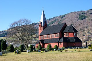
Stedje Church is the main parish church in Sogndal Municipality in Sogn og Fjordane county, Norway. It is located in the village of Sogndalsfjøra, near the shore of the Sogndalsfjorden. The church is part of the Stedje parish in the Indre Sogn deanery in the Diocese of Bjørgvin. The red, wooden church, which has 400 seats, was built in 1867. It was consecrated on 17 December 1867 by the Bishop Peter Hersleb Graah Birkeland. The architect Christian Christie made the designs for the building. This church was built to replace an older stave church. This has been a church site since the 9th century AD.

Ølmheim Church is a parish church in Sogndal Municipality in Sogn og Fjordane county, Norway. It is located in the village of Nornes, on the northern shore of the Sogndalsfjorden. The church is part of the Norum parish in the Indre Sogn deanery in the Diocese of Bjørgvin. The white, wooden church, which has 230 seats, was consecrated in 1863. The architect Christian Henrik Grosch made the designs for the building. In earlier times, the church has been called Ylhmeim Church, after the name of the nearby farm; however, from about 1840 Norum was the name of both the church and the parish until the former got its old name back in 2015.