Communications in the Solomon Islands.
A per capita GDP of $3,200 ranks Solomon Islands as a lesser developed nation. Over 75% of its labour force is engaged in subsistence farming and fishing.

Cannery Row is the waterfront street bordering the city of Pacific Grove, California, but officially in the New Monterey section of Monterey, California. It was the site of a number of now-defunct sardine canning factories. The last cannery closed in 1973. The street name, formerly a nickname for Ocean View Avenue, became official in January 1958 to honor John Steinbeck and his novel Cannery Row. In the novel's opening sentence, Steinbeck described the street as "a poem, a stink, a grating noise, a quality of light, a tone, a habit, a nostalgia, a dream."

Munda is the largest settlement on the island of New Georgia in the Western Province of Solomon Islands, and consists of a number of villages. It is located at the southwestern tip of the western end of New Georgia, and the large Roviana Lagoon is just offshore.

The New Georgia Islands are part of the Western Province of Solomon Islands. They are located to the northwest of Guadalcanal. The larger islands are mountainous and covered in rain forest. The main islands are New Georgia, Vella Lavella, Kolombangara, Ghizo, Vangunu, Rendova and Tetepare. They are surrounded by coral reefs and include the Marovo Lagoon.

New Georgia, with an area of 2,037 km2 (786 sq mi), is the largest of the islands in Western Province, Solomon Islands, and the 224th-largest island in the world. Since July 1978, the island has been part of the independent state of Solomon Islands.
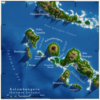
Kolombangara is an island in the New Georgia Islands group of the nation state of Solomon Islands in the southwestern Pacific Ocean. The name is from a local language, a rough translation of its meaning is "Water Lord" with approximately 80 rivers and streams running down its flanks.
Industries in the Maldives center around fishing and tourism, with some overlap between the two with recreational fishing.
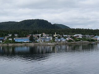
Bella Bella, also known as Waglisla, is the home of the Heiltsuk and is an unincorporated community and Indian reserve community located within Bella Bella Indian Reserve No. 1 on the east coast of Campbell Island in the Central Coast region of British Columbia, Canada. Bella Bella is located 98 nautical miles (181 km) north of Port Hardy, on Vancouver Island, and 78 nautical miles (144 km) west of Bella Coola. The community is on Lama Passage, part of the Inside Passage – a transportation route linking the area, and northern British Columbia as well as Alaska for marine vessels carrying cargo, passengers and recreational boaters from the south coast. The settlement "forms a national capital of sorts" to the Heiltsuk.

Rennell Island, locally known as Mugaba, is the main island of two inhabited islands that make up the Rennell and Bellona Province in the nation state of Solomon Islands. Rennell Island has a land area of 660 square kilometres (250 sq mi) that is about 80 kilometres (50 mi) long and 14 kilometres (8.7 mi) wide. It is the second largest raised coral atoll in the world with the largest lake in the insular Pacific, Lake Tegano, a lake that is listed as a World Heritage Site. Rennell Island has a population of about 1,840 persons of Polynesian descent who primarily speak Rennellese, Pijin and some English. Rennell and Bellona Islands are two of the few islands in the otherwise Melanesian Solomon Islands archipelago classified as a Polynesian outlier; others being Sikaiana, Ontong Java, Tikopia, Anuta, Duff Islands, and some Reef Islands.

Kindu is a city in the Democratic Republic of Congo, the capital of Maniema province. It has a population of about 200,000 and is situated on the Lualaba River at an altitude of about 500 metres, and is about 400 km west of Bukavu.

Favignana is a comune including three islands of the Aegadian Islands, southern Italy. It is situated approximately 18 kilometres west of the coast of Sicily, between Trapani and Marsala, the coastal area where the Stagnone Lagoon and the international airport of Trapani, are sited.

Choiseul Island, native name Lauru, is the largest island of the Choiseul Province, Solomon Islands, at 7.08°S 157°E. The administrative headquarters of Choiseul Province is situated in the town of Taro, on Taro Island.
Lola Island is an island in within Vona Vona Lagoon in Western Province, in the independent nation of Solomon Islands.

Uepi is an island in Western Province, in the independent nation of Solomon Islands. It is noted for its high quality blue-water drop-off scuba diving.
Arnarvon Islands are a group of islands in Solomon Islands. They are located in Isabel Province and nearby to Wagina Island in Choiseul Province.
A small, resident expatriate community of Japanese nationals was present in Solomon Islands from the 1970s onwards. Japanese nationals in Solomon Islands are usually employees of fishing corporations that had established branch companies in the country. The majority of them are fishermen from the Miyako Islands in the Ryukyu Islands, as well as a few Japanese mainlanders.

Canned or tinned fish are food fish which have been processed, sealed in an airtight container such as a sealed tin can, and subjected to heat. Canning is a method of preserving food, and provides a typical shelf life ranging from one to five years. They are usually opened via a can opener, but sometimes have a pull-tab so that they can be opened by hand. In the past it was common for many cans to have a key that would be turned to peel the lid of the tin off; most predominately sardines, among others.

The Coral reefs of the Solomon Islands consists of six major islands and over 986 smaller islands, in Oceania, to the east of Papua New Guinea and northwest of Vanuatu. The Solomon Islands lie between latitudes 5° and 13°S, and longitudes 155° and 169°E. The distance between the westernmost and easternmost islands is about 1,500 km (930 mi). The Santa Cruz Islands are situated north of Vanuatu and are especially isolated at more than 200 km (120 mi) from the other islands. The Solomon Islands has the 22nd largest Exclusive Economic Zone of 1,589,477 km2 (613,701 sq mi) of the Pacific Ocean.
Saupiquet is a French company founded in Nantes in 1891 which specializes in fish canning, particularly tuna.
