
In meteorology, a cyclone is a large air mass that rotates around a strong center of low atmospheric pressure, counterclockwise in the Northern Hemisphere and clockwise in the Southern Hemisphere as viewed from above. Cyclones are characterized by inward-spiraling winds that rotate about a zone of low pressure. The largest low-pressure systems are polar vortices and extratropical cyclones of the largest scale. Warm-core cyclones such as tropical cyclones and subtropical cyclones also lie within the synoptic scale. Mesocyclones, tornadoes, and dust devils lie within the smaller mesoscale. Upper level cyclones can exist without the presence of a surface low, and can pinch off from the base of the tropical upper tropospheric trough during the summer months in the Northern Hemisphere. Cyclones have also been seen on extraterrestrial planets, such as Mars, Jupiter, and Neptune. Cyclogenesis is the process of cyclone formation and intensification. Extratropical cyclones begin as waves in large regions of enhanced mid-latitude temperature contrasts called baroclinic zones. These zones contract and form weather fronts as the cyclonic circulation closes and intensifies. Later in their life cycle, extratropical cyclones occlude as cold air masses undercut the warmer air and become cold core systems. A cyclone's track is guided over the course of its 2 to 6 day life cycle by the steering flow of the subtropical jet stream.

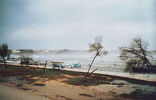
Fog is a visible aerosol consisting of tiny water droplets or ice crystals suspended in the air at or near the Earth's surface. Fog can be considered a type of low-lying cloud usually resembling stratus, and is heavily influenced by nearby bodies of water, topography, and wind conditions. In turn, fog affects many human activities, such as shipping, travel, and warfare.

Upwelling is an oceanographic phenomenon that involves wind-driven motion of dense, cooler, and usually nutrient-rich water from deep water towards the ocean surface. It replaces the warmer and usually nutrient-depleted surface water. The nutrient-rich upwelled water stimulates the growth and reproduction of primary producers such as phytoplankton. The biomass of phytoplankton and the presence of cool water in those regions allow upwelling zones to be identified by cool sea surface temperatures (SST) and high concentrations of chlorophyll a.

An Anticyclone is a weather phenomenon defined as a large-scale circulation of winds around a central region of high atmospheric pressure, clockwise in the Northern Hemisphere and counterclockwise in the Southern Hemisphere as viewed from above. Effects of surface-based anticyclones include clearing skies as well as cooler, drier air. Fog can also form overnight within a region of higher pressure.

In meteorology, a low-pressure area, low area or low is a region where the atmospheric pressure is lower than that of surrounding locations. Low-pressure areas are commonly associated with inclement weather, while high-pressure areas are associated with lighter winds and clear skies. Winds circle anti-clockwise around lows in the northern hemisphere, and clockwise in the southern hemisphere, due to opposing Coriolis forces. Low-pressure systems form under areas of wind divergence that occur in the upper levels of the atmosphere (aloft). The formation process of a low-pressure area is known as cyclogenesis. In meteorology, atmospheric divergence aloft occurs in two kinds of places:
The bora is a northerly to north-easterly katabatic wind in areas near the Adriatic Sea. Similar nomenclature is used for north-eastern winds in other littoral areas of eastern Mediterranean and Black Sea basins.

The trade winds or easterlies are the permanent east-to-west prevailing winds that flow in the Earth's equatorial region. The trade winds blow mainly from the northeast in the Northern Hemisphere and from the southeast in the Southern Hemisphere, strengthening during the winter and when the Arctic oscillation is in its warm phase. Trade winds have been used by captains of sailing ships to cross the world's oceans for centuries. They enabled colonial expansion into the Americas, and trade routes to become established across the Atlantic Ocean and the Pacific Ocean.

Cyclogenesis is the development or strengthening of cyclonic circulation in the atmosphere. Cyclogenesis is an umbrella term for at least three different processes, all of which result in the development of some sort of cyclone, and at any size from the microscale to the synoptic scale.

A pressure system is a peak or lull in the sea level pressure distribution. The surface pressure at sea level varies minimally, with the lowest value measured 87 kilopascals (26 inHg) and the highest recorded 108.57 kilopascals (32.06 inHg). High- and low-pressure systems evolve due to interactions of temperature differentials in the atmosphere, temperature differences between the atmosphere and water within oceans and lakes, the influence of upper-level disturbances, as well as the amount of solar heating or radiationized cooling an area receives. Pressure systems cause weather to be experienced locally. Low-pressure systems are associated with clouds and precipitation that minimize temperature changes throughout the day, whereas high-pressure systems normally associate with dry weather and mostly clear skies with larger diurnal temperature changes due to greater radiation at night and greater sunshine during the day. Pressure systems are analyzed by those in the field of meteorology within surface weather maps.

An Atlantic hurricane is a tropical cyclone that forms in the Atlantic Ocean, primarily between the months of June and November. A hurricane differs from a cyclone or typhoon only on the basis of location. A hurricane is a storm that occurs in the Atlantic Ocean and northeastern Pacific Ocean, a typhoon occurs in the northwestern Pacific Ocean, and a cyclone occurs in the South Pacific Ocean or Indian Ocean.

Berg wind is the South African name for a katabatic wind: a hot dry wind blowing down the Great Escarpment from the high central plateau to the coast.

Extratropical cyclones, sometimes called mid-latitude cyclones or wave cyclones, are low-pressure areas which, along with the anticyclones of high-pressure areas, drive the weather over much of the Earth. Extratropical cyclones are capable of producing anything from cloudiness and mild showers to severe gales, thunderstorms, blizzards, and tornadoes. These types of cyclones are defined as large scale (synoptic) low pressure weather systems that occur in the middle latitudes of the Earth. In contrast with tropical cyclones, extratropical cyclones produce rapid changes in temperature and dew point along broad lines, called weather fronts, about the center of the cyclone.

Severe weather is any dangerous meteorological phenomenon with the potential to cause damage, serious social disruption, or loss of human life. Types of severe weather phenomena vary, depending on the latitude, altitude, topography, and atmospheric conditions. High winds, hail, excessive precipitation, and wildfires are forms and effects of severe weather, as are thunderstorms, downbursts, tornadoes, waterspouts, tropical cyclones, and extratropical cyclones. Regional and seasonal severe weather phenomena include blizzards (snowstorms), ice storms, and duststorms.

Wind is the natural movement of air or other gases relative to a planet's surface. Winds occur on a range of scales, from thunderstorm flows lasting tens of minutes, to local breezes generated by heating of land surfaces and lasting a few hours, to global winds resulting from the difference in absorption of solar energy between the climate zones on Earth. The two main causes of large-scale atmospheric circulation are the differential heating between the equator and the poles, and the rotation of the planet. Within the tropics and subtropics, thermal low circulations over terrain and high plateaus can drive monsoon circulations. In coastal areas the sea breeze/land breeze cycle can define local winds; in areas that have variable terrain, mountain and valley breezes can prevail.
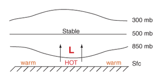
Thermal lows, or heat lows, are non-frontal low-pressure areas that occur over the continents in the subtropics during the warm season, as the result of intense heating when compared to their surrounding environments. Thermal lows occur near the Sonoran Desert, on the Mexican plateau, in California's Great Central Valley, in the Sahara, in the Kalahari, over north-west Argentina, in South America, over the Kimberley region of north-west Australia, over the Iberian peninsula, and over the Tibetan plateau.
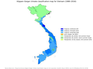
Vietnam has a monsoon-influenced climate typical of that of mainland Southeast Asia. The diverse topography, long latitude, and influences from the South China Sea lead to climatic conditions varying significantly between regions. Northern Vietnam has a humid subtropical climate with the Köppen climate classification and has times to be influenced by cold waves from the Northeast, northern part of Central Vietnam also has times to be influenced by cold waves, southern part of Central Vietnam and Southern Vietnam are completely tropical and hot around year.

The 1978–79 Australian region cyclone season was the only season in which a reconnaissance aircraft flew into a tropical cyclone. Operationally, Australia's Bureau of Meteorology (BOM) tracked eleven tropical cyclones, while two additional systems were later added to the United States's Joint Typhoon Warning Center (JTWC) best track. Prior to 1985, the Australian region basin was defined as in the southern hemisphere between 80°E and 160°E, with the modern day season boundaries ranging from 1 November to 30 April of the following year. The first storm, an unnamed system, developed on 19 November 1978. The final cyclone, Kevin, dissipated by 12 May 1979. Tropical cyclones in this area were monitored by three Tropical Cyclone Warning Centres (TCWCs): the BOM in Perth, Darwin, and Brisbane.

A cold-core low, also known as an upper level low or cold-core cyclone, is a cyclone aloft which has an associated cold pool of air residing at high altitude within the Earth's troposphere, without a frontal structure. It is a low pressure system that strengthens with height in accordance with the thermal wind relationship. If a weak surface circulation forms in response to such a feature at subtropical latitudes of the eastern north Pacific or north Indian oceans, it is called a subtropical cyclone. Cloud cover and rainfall mainly occurs with these systems during the day.

Cyprus has a subtropical climate - Mediterranean and semi-arid type - according to Köppen climate classification signes Csa and BSh, with very mild winters and warm to hot summers. Snow is possible only in the Troodos mountains in the central part of the island. Rain occurs mainly in winter, with summer being generally dry.
