Related Research Articles

Washington County is a county located in the U.S. state of North Carolina. As of the 2020 census, the population was 11,003. Its county seat is Plymouth. The county was formed in 1799 from the western third of Tyrrell County. It was named for George Washington.

Tyrrell County is a county located in the U.S. state of North Carolina. As of the 2020 census, the population was 3,245, making it the least populous county in North Carolina. Its county seat is Columbia. The county was created in 1729 as Tyrrell Precinct and gained county status in 1739.

Dare County is the easternmost county in the U.S. state of North Carolina. As of the 2020 census, the population was 36,915. Its county seat is Manteo.

The Great Dismal Swamp is a large swamp in the Coastal Plain Region of southeastern Virginia and northeastern North Carolina in the eastern United States, between Norfolk, Virginia, and Elizabeth City, North Carolina. It is located in parts of the southern Virginia independent cities of Chesapeake and Suffolk and northern North Carolina counties of Gates, Pasquotank, and Camden. Some estimates place the original size of the swamp at over one million acres (4,000 km2). As of 2022 the size of the Great Dismal Swamp is around 750 square miles.

The Great Dismal Swamp National Wildlife Refuge was created in 1974 to help protect and preserve a portion of the Great Dismal Swamp, a marshy region on the Coastal Plain of southeastern Virginia and northeastern North Carolina between Norfolk, Virginia, and Elizabeth City, North Carolina in the United States. It is located in parts of the independent cities of Chesapeake and Suffolk in Virginia, and the counties of Camden, Gates, and Pasquotank in North Carolina.

Attwater Prairie Chicken National Wildlife Refuge is a federally protected refugium encompassing one of the largest remnants of coastal prairie habitat remaining in southeast Texas, United States, and home to one of the last populations of critically endangered Attwater's prairie chickens, a ground-dwelling grouse of the coastal prairie ecosystem.

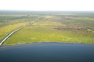
The Scuppernong River is a blackwater river that flows through Tyrrell County and Washington County, North Carolina, into the Albemarle Sound. The river shares its name with the Scuppernong grapes native to the area. The river has a history closely linked to colonization and agricultural utilization. Currently, the Pocosin Lakes National Wildlife Refuge and Pettigrew State Park can be found on the banks of the river. The River is celebrated annually through the Scuppernong River Festival.
The Alligator River National Wildlife Refuge is a 152,000-acre (620 km2) National Wildlife Refuge located in eastern North Carolina along the Atlantic Coast. It was established on March 14, 1984, to preserve and protect a unique wetland habitat type—the pocosin—and its associated wildlife species.
Pea Island National Wildlife Refuge is a national wildlife refuge located on North Carolina's Pea Island, a coastal barrier island and part of a chain of islands known as the Outer Banks, adjacent to Cape Hatteras National Seashore. The sanctuary is located 10 miles (16 km) south of Nags Head, North Carolina on NC 12.
Santee National Wildlife Refuge is a 15,000-acre (61 km2) refuge alongside Lake Marion, an impoundment of the Santee River of Clarendon County, South Carolina.

The Inner Banks is a neologism made up by developers and tourism promoters to describe the inland coastal region of eastern North Carolina. Without historical precedent, the term "Inner Banks" is an early 21st-century construct that is part of an attempt to rebrand the mostly agrarian Coastal Plains east of I-95 as a more attractive region for visitors and retirees.

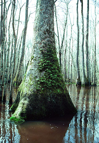
Pocosin is a type of palustrine wetland with deep, acidic, sandy, peat soils. Groundwater saturates the soil except during brief seasonal dry spells and during prolonged droughts. Pocosin soils are nutrient-deficient (oligotrophic), especially in phosphorus.

The Croatan National Forest is a U.S. National Forest, was established on July 29, 1936, and is located on the Atlantic coast of North Carolina. It is administered by the United States Forest Service, a part of the United States Department of Agriculture. The forest is managed together with the other three North Carolina National Forests from common headquarters in Asheville, North Carolina. However, Croatan has a local ranger district office in New Bern.

The Pocosin Lakes National Wildlife Refuge is located in North Carolina's Inner Banks on the Albemarle-Pamlico Peninsula in Hyde, Tyrrell, and Washington Counties, North Carolina. Its headquarters is located in Columbia.
Alligator River is a small river in eastern North Carolina, separating Dare County and Tyrrell County. It empties into Albemarle Sound. A 21-mile canal connects the Alligator River with Pungo River to its west. The Lindsey C. Warren Bridge of U.S. Route 64 crosses the river.

The Middle Atlantic coastal forests are a temperate coniferous forest mixed with patches of evergreen broadleaved forests along the coast of the southeastern United States.
The South Carolina Lowcountry National Wildlife Refuge Complex is an administrative organization that manages U.S. Fish and Wildlife Service wildlife refuges in eastern South Carolina. The complex includes:

The protected areas of North Carolina cover roughly 3.8 million acres, making up 11% of the total land in the state. 86.5% of this protected land is publicly owned and is managed by different federal and state level authorities and receive varying levels of protection. Some areas are managed as wilderness while others are operated with acceptable commercial exploitation. The remainder of the land is privately owned, but willingly entered into conservation easement management agreements, or are owned by various nonprofit conservation groups such as the National Audubon Society and The Nature Conservancy. North Carolina contains 1 National Park, and various other federally owned protected land including 2 National Seashores, 5 National Forests, 12 Wildlife Refuges, and the southern half of the Blue Ridge Parkway. North Carolina has an extensive state park system of 42 open units, 35 of which are state parks, 4 that are recreation areas, and 3 staffed state natural areas, along with other designated units managed by the North Carolina Department of Natural and Cultural Resources.
Alligator Lake, also called New Lake, is a natural freshwater lake in Hyde County, North Carolina. It has a diameter of approximately 3.5 miles, and its 6,000 acre area makes it one of the five largest natural freshwater lakes in North Carolina. Like the other freshwater lakes of North Carolina, it is quite shallow, having a maximum depth of between 6 and 7 feet. Its two outlets are Alligator River and Pungo River.
References
- ↑ "About the Complex". Pocosin Lakes National Wildlife Refuge. U.S. Fish and Wildlife Service. Retrieved September 18, 2016.