
North Carolina Highway 24 (NC 24) is the longest primary state highway in the U.S. state of North Carolina. Traveling east–west between the Charlotte metropolitan area and the Crystal Coast, connecting the cities of Charlotte, Fayetteville, Jacksonville and Morehead City.
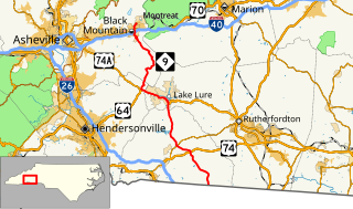
North Carolina Highway 9 (NC 9) is a 46.4-mile (74.7 km) primary state highway in the U.S. state of North Carolina. It serves as a connector route from South Carolina Highway 9 to eastern portions of the Appalachians around Asheville.
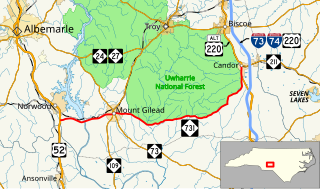
North Carolina Highway 49 (NC 49) is a primary state highway in the U.S. state of North Carolina. It traverses much of the Piedmont region of North Carolina.

North Carolina Highway 87 (NC 87) is a primary state highway in the U.S. state of North Carolina. NC 87 begins in the Atlantic coastal town of Southport and crosses into Virginia at the Virginia state line five miles (8 km) north of Eden in Rockingham County. At 240 miles (390 km) in length, NC 87 is the second longest state highway in the U.S. state of North Carolina. Labeled as a north–south route, NC 87 travels along a relatively straight southeast–northwest path, connecting Cape Fear region with the Piedmont and connecting the cities of Fayetteville, Sanford, and Burlington.

North Carolina Highway 27 (NC 27) is a primary state highway in the U.S. state of North Carolina. The route traverses 198 miles (319 km) through southern and central North Carolina, about 100 miles (160 km) of it as a concurrency with NC 24.

North Carolina Highway 32 (NC 32) is a primary state highway in the U.S. state of North Carolina; it goes through several counties and small communities in the northeastern Inner Banks part of the state. It is 103 miles (166 km) in length, and crosses the Albemarle Sound south of Edenton, along with NC 37 and NC 94. The highway continues into Virginia as SR 32.

North Carolina Highway 143 (NC 143) is a primary state highway in the U.S. state of North Carolina. It runs from the Tennessee state line to NC 28, near the community of Stecoah. It is best known for its 18-mile (29 km) section of the Cherohala Skyway, shared with Tennessee State Route 165.

North Carolina Highway 68 (NC 68) is a north–south state highway in North Carolina. It serves as a connector between Interstate 40 (I-40)/ US 421 and Piedmont Triad International Airport. On its routing from Thomasville to Stokesdale, NC 68 passes through urban High Point, the western outskirts of Greensboro, and the town of Oak Ridge. The segment from just north of the I-40/US 421 interchange to Pleasant Ridge Road in Guilford County is a limited access freeway.

North Carolina Highway 801 (NC 801) is a primary state highway in the U.S. state of North Carolina. The highway runs north–south, traversing the central Piedmont region of the state.

North Carolina Highway 111 (NC 111) is a 126.0-mile-long (202.8 km) primary state highway in the U.S. state of North Carolina. Traveling north–south through Eastern North Carolina, it connects the various rural towns and communities with the cities of Jacksonville, Goldsboro and Tarboro.

North Carolina Highway 242 (NC 242) is a primary state highway in the U.S. state of North Carolina. It traverses from Cerro Gordo to Benson, connecting the cities of Bladenboro, Elizabethtown, and Roseboro.
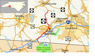
North Carolina Highway 216 is a primary state highway in the U.S. state of North Carolina. The highway runs north–south, from the South Carolina state line to NC 274 near the unincorporated community of Tryon.

South Carolina Highway 216 (SC 216) is a primary 1.22-mile (1.96 km) state highway in the state of South Carolina. The highway runs north–south, from the Kings Mountain National Military Park to North Carolina Highway 216 (NC 216) at the North Carolina state line.

North Carolina Highway 308 (NC 308) is a primary state highway in the U.S. state of North Carolina. It serves mainly to connect the city of Windsor to communities and towns in eastern Bertie County.

North Carolina Highway 231 (NC 231) is a 25.4-mile-long (40.9 km) primary state highway in the U.S. state of North Carolina. The highway serves to connect communities in northern Johnston and western Nash counties.
North Carolina Highway 124 (NC 124) is a primary state highway in the U.S. state of North Carolina. It serves to connect the town of Macclesfield and as an alternate to NC 42, entirely in Edgecombe County.

North Carolina Highway 772 (NC 772) is a primary state highway in the U.S. state of North Carolina. NC 772 is a two-lane rural highway that traverses 10.3 miles (16.6 km) from U.S. Route 311 (US 311) north of Pine Hall to NC 704 in Prestonville.

North Carolina Highway 704 (NC 704) is a primary state highway in the U.S. state of North Carolina. The highway connects Madison with northern Stokes County and the Wentworth-Reidsville area.
North Carolina Highway 731 (NC 731) is a primary state highway in the U.S. state of North Carolina. The highway serves as the main thoroughfare in southern Montgomery County.


