
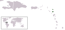
Antigua and Barbuda is a sovereign archipelagic country in the Caribbean. It lies at the conjuncture of the Caribbean Sea and the Atlantic Ocean in the Leeward Islands part of the Lesser Antilles.
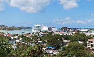
St. John's is the capital and largest city of Antigua and Barbuda, part of the West Indies in the Caribbean Sea. With a population of 22,219, St. John's is the commercial centre of the nation and the chief port of the island of Antigua.
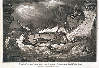
The history of Antigua and Barbuda covers the period from the arrival of the Archaic peoples thousands of years ago to the present day. Prior to European colonization, the lands encompassing present-day Antigua and Barbuda were inhabited by three successive Amerindian societies. The island was claimed by England, who settled the islands in 1632. Under English/British control, the islands witnessed an influx of both Britons and African slaves migrate to the island. In 1981, the islands were granted independence as the modern state of Antigua and Barbuda.
Barbuda is an island and dependency located in the eastern Caribbean forming part of the twin-island state of Antigua and Barbuda as an autonomous entity. Barbuda is located approximately 30 miles (48 km) north of Antigua. The only settlements on the island are Codrington and its surrounding localities. Barbuda is a flat island with the western portion being dominated by Codrington Lagoon, and the eastern portion being dominated by the elevated plateau of the Barbuda Highlands, with salty ponds and scrubland spread throughout the island. The climate is classified as tropical marine.
The following is an alphabetical list of topics related to the nation of Antigua and Barbuda.

Antigua and Barbuda is an island nation made up of: Antigua island, which is divided into six parishes; and of the two dependencies of Barbuda island and Redonda island.
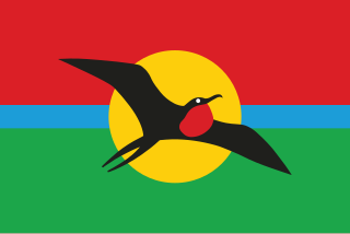
The national flag of Antigua and Barbuda was adopted on 27 February 1967 to mark the achievement of self-government. A competition to design the flag was held in which more than 600 local people entered. The winning design was put forth by nationally well-known artist and sculptor Sir Reginald Samuel.

The music of Antigua and Barbuda is largely African in character, and has only felt a limited influence from European styles due to the population of Antigua and Barbuda descending mostly from West Africans who were made slaves by Europeans.

Saint Philip, officially the Parish of Saint Philip, is a civil parish of Antigua and Barbuda, on the easternmost portion of Antigua island. Its capital is the village of St. Philip's. Saint Philip borders Saint Peter and Saint Paul. Saint Philip faces the Atlantic Ocean. Saint Philip is surrounded by various islands and islets. It had an estimated population of 3,689 in 2018, which makes it the least populous parish of Antigua and Barbuda.

Saint John, officially the Parish of Saint John, is a civil parish of Antigua and Barbuda, on the northwestern portion of Antigua island. Its capital is the city of St. John's. Saint John borders Saint Mary, Saint Peter, Saint George, and Saint Paul. Saint John faces the Caribbean Sea. Saint John is surrounded by some of Antigua's most premier beaches. Saint John had a population of 56,736 in a 2018 estimate, making it home to the majority of the population in Antigua and Barbuda.
Saint John's or St. John's may refer to:

The Antigua and Barbuda national football team is the national team of Antigua and Barbuda.

Antigua, also known as Waladli or Wadadli by the local population, is an island in the Lesser Antilles. It is one of the Leeward Islands in the Caribbean region and the most populous island of the country of Antigua and Barbuda. Antigua and Barbuda became an independent state within the Commonwealth of Nations on 1 November 1981.
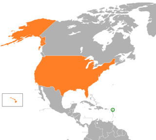
Relations between Antigua and Barbuda and the United States have been friendly since Antigua and Barbuda's independence from the United Kingdom in 1981.
The following outline is provided as an overview of and introduction to Antigua and Barbuda:

Antigua and Barbuda lie in the eastern arc of the Leeward Islands of the Lesser Antilles, separating the Atlantic Ocean from the Caribbean Sea. Antigua is 650 km (400 mi) southeast of Puerto Rico; Barbuda lies 48 km (30 mi) due north of Antigua, and the uninhabited island of Redonda is 56 km (35 mi) southwest of Antigua.
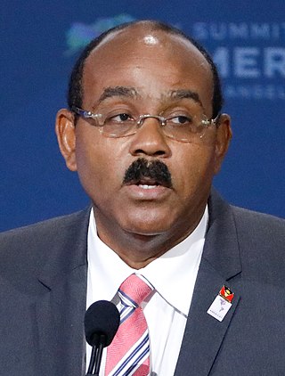
Gaston Alfonso Browne is an Antiguan politician serving as the prime minister of Antigua and Barbuda and leader of the Labour Party since 2014. Before entering politics, he was a banker and businessman.

Five Islands Village is a village located on the northwest coast of Antigua, within Saint John Parish in Antigua and Barbuda.

Squatting in the island country of Antigua and Barbuda in the West Indies is the occupation of unused land or derelict buildings without the permission of the owner. Historically, native Barbudans were seen as squatters and after Hurricane Irma in 2017, Prime Minister Gaston Browne offered people he termed squatters the chance to buy their land.
Royal tours of Antigua and Barbuda by its royal family have been taking place since the 20th century. Elizabeth II, Queen of Antigua and Barbuda, visited the country thrice: in 1966, 1977, and 1985.
