Geography of the United States Virgin Islands

The Virgin Islands are geologically and biogeographically the easternmost part of the Greater Antilles, the northern islands belonging to the Puerto Rican Bank and St. Croix being a displaced part of the same geologic structure. Politically, the British Virgin Islands have been governed as the western island group of the Leeward Islands, which are the northern part of the Lesser Antilles, and form the border between the Caribbean Sea and the Atlantic Ocean. The archipelago is separated from the true Lesser Antilles by the Anegada Passage and from the main island of Puerto Rico by the Virgin Passage.
Kingshill is a settlement on the island of Saint Croix in the United States Virgin Islands. Kingshill is home to the University of the Virgin Islands campus in St. Croix. The St. Croix campus opened in 1964.

Cruz Bay, U.S. Virgin Islands is the main town on the island of Saint John in the United States Virgin Islands. According to the 2000 census, Cruz Bay had a population of 2,743.
The area code (340) is the local telephone area code of U.S. Virgin Islands. The (340) area code was created during a split from the original (809) area code, which began permissive dialing on 1 June 1997 and ended 30 June 1998.

Dog Islands are a small group of islets among the British Virgin Islands in the Caribbean.
The Seahorse Islands is a chain of long and narrow sandy islands in western North Slope Borough, Alaska, United States. They are located between Peard Bay and the Chukchi Sea, 1.7 km (1.1 mi) east of Point Franklin. The longest island is about 5 km (3.1 mi) in length and the highest point of the islands is 2 m (6.6 ft). The shape of these coastal islands has changed over the years.
Minnie Lake Township is a civil township in Barnes County, North Dakota, USA. As of the 2000 census, its population was 63.
Weimer Township is a civil township in Barnes County, North Dakota, USA. As of the 2000 census, its population was 53.
Williams Corner is an unincorporated community in Northumberland County, in the U.S. state of Virginia.
Hermitage is an area of Virgin Islands National Park on the island of Saint John in the United States Virgin Islands. It is located along the north side of Coral Bay, between the town of Coral Bay and the island's inhabited East End. The mangroves of Princess Bay, inside the National Park, are a popular kayaking and snorkeling spot.
Johns Folly is a neighborhood on the island of Saint John in the United States Virgin Islands. It is located on the east side of the island, south of Coral Bay and north of Salt Pond Bay.
Green Kay is a settlement on the island of Saint Croix in the United States Virgin Islands. It is located 3.3 miles (5.3 km) east of Christiansted.
North Star is a settlement on the island of Saint Croix in the United States Virgin Islands.
Sion Farm is a settlement on the island of Saint Croix in the United States Virgin Islands.
Windsor is a settlement on the island of Saint Croix in the United States Virgin Islands.

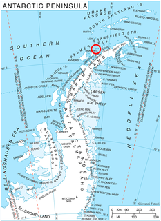
Leshko Point is the point on the north side of the entrance to Beripara Cove on the southeast coast of Liège Island in the Palmer Archipelago, Antarctica.

Ash Ridge is an unincorporated community in Brown County, in the U.S. state of Ohio.

Chester is an unincorporated community in Wayne Township, Wayne County, in the U.S. state of Indiana.


