
Cape Cod is a peninsula extending into the Atlantic Ocean from the southeastern corner of Massachusetts, in the northeastern United States. Its historic, maritime character and ample beaches attract heavy tourism during the summer months. The name Cape Cod, coined in 1602 by Bartholomew Gosnold, is the ninth oldest English place-name in the U.S.
The Cape Cod National Seashore (CCNS) encompasses 43,607 acres on Cape Cod, in Massachusetts. CCNS was created on August 7, 1961, by President John F. Kennedy, when he signed a bill enacting the legislation he first co-sponsored as a Senator a few years prior. It includes ponds, woods and beachfront of the Atlantic coastal pine barrens ecoregion. The CCNS includes nearly 40 miles (64 km) of seashore along the Atlantic-facing eastern shore of Cape Cod, in the towns of Provincetown, Truro, Wellfleet, Eastham, Orleans and Chatham. It is administered by the National Park Service.

Provincetown is a New England town located at the extreme tip of Cape Cod in Barnstable County, Massachusetts, in the United States. A small coastal resort town with a year-round population of 3,664 as of the 2020 United States Census, Provincetown has a summer population as high as 60,000. Often called "P-town" or "Ptown", the locale is known as a vacation destination for its beaches, harbor, artists and tourist industry.
Eastham is a town in Barnstable County, Massachusetts, United States, Barnstable County being coextensive with Cape Cod. The population was 5,752 at the 2020 census.

Truro is a town in Barnstable County, Massachusetts, United States, comprising two villages: Truro and North Truro. Located slightly more than 100 miles (160 km) by road from Boston, it is a summer vacation community just south of the northern tip of Cape Cod, in an area known as the "Outer Cape". English colonists named it after Truro in Cornwall, United Kingdom.

Provincetown Harbor is a large natural harbor located in the town of Provincetown, Massachusetts. The harbor is mostly 30 to 90 feet deep and stretches roughly 1 mile (1.6 km) from northwest to southeast and 2 miles (3.2 km) from northeast to southwest – one large, deep basin with no dredged channel necessary for boats to enter and exit.
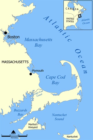
Cape Cod Bay is a large bay of the Atlantic Ocean adjacent to the U.S. state of Massachusetts. Measuring 604 square miles (1,560 km2) below a line drawn from Brant Rock in Marshfield to Race Point in Provincetown, Massachusetts, it is enclosed by Cape Cod to the south and east, and Plymouth County, Massachusetts, to the west. To the north of Cape Cod Bay lie Massachusetts Bay and the Atlantic Ocean. Cape Cod Bay is the southernmost extremity of the Gulf of Maine. Cape Cod Bay is one of the bays adjacent to Massachusetts that give it the name Bay State. The others are Narragansett Bay, Buzzards Bay, and Massachusetts Bay.

The St. Lawrence and Atlantic Railroad, known as St-Laurent et Atlantique Quebec in Canada, is a short-line railway operating between Portland, Maine, on the Atlantic Ocean, and Montreal, Quebec, on the St. Lawrence River. It crosses the Canada–US border at Norton, Vermont, and Stanhope, Quebec, and is owned by short-line operator Genesee & Wyoming.
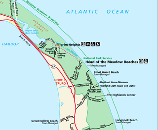
North Truro is a village in the town of Truro, Massachusetts, United States. Due to its proximity to urbanized Provincetown, it is somewhat more densely developed than the rest of the town, with houses and small resort facilities lining the two main thoroughfares, U.S. Route 6 and MA Route 6A. It is home to Truro Vineyards, one of two operating wineries on Cape Cod. North Truro is located at 42°03′35″N70°08′31″W.

Massachusetts Route 6A is the state road for two sections formerly known as U.S. Route 6 (US 6) on Cape Cod. Most of Route 6A is also known as the Old King's Highway. Combining the 2 major sections, the highway is approximately 62 miles (100 km) long.
The Lexington and West Cambridge Railroad was a railroad company chartered in 1845 and opened in 1846 that operated in eastern Massachusetts. It and its successors provided passenger service until 1977 and freight service until 1980 or early 1981.

The Cape Cod Rail Trail (CCRT) is a 25.5-mile (41.0 km) paved rail trail located on Cape Cod in Massachusetts. The trail route passes through the towns of Yarmouth, Dennis, Harwich, Brewster, Orleans, Eastham, and Wellfleet. It connects to the 6-plus mile (10 km) Old Colony Rail Trail leading to Chatham, the 2 mile Yarmouth multi-use trail, and 8 miles (13 km) of trails within Nickerson State Park. Short side trips on roads lead to national seashore beaches including Coast Guard Beach at the end of the Nauset Bike Trail in Cape Cod National Seashore. The trail is part of the Claire Saltonstall Bikeway.

The Atlantic House in Provincetown, Massachusetts is a drinking establishment that has been in continual operation on the tip of Cape Cod for over two centuries.

Provincetown station was a train station located on Bradford Street between Alden and Standish Streets in Provincetown, Massachusetts.
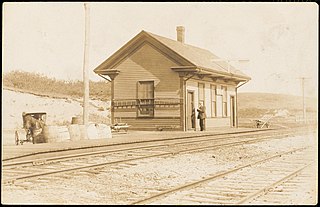
Truro station was a train station located in Truro, Massachusetts at the west end of Depot Road.

South Truro station was a train station located in the southern part of Truro, Massachusetts. The first passenger service was on July 23, 1873.

The Jenny Lind Tower is a stone tower located in North Truro, Massachusetts. It is named after the 19th-century opera singer Jenny Lind, who is rumored to have climbed the tower when it was located in Boston to prevent a riot among people who were unable to attend her concert. It is located roughly between the Highland Light lighthouse and North Truro Air Force Station. It is seventy feet tall.
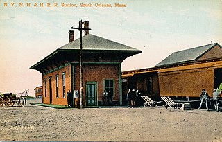
Orleans station was a train station in Orleans, Massachusetts. It was built by the Old Colony Railroad in 1865 when the rail line was extended from Yarmouth to Orleans. The original station was replaced by a newer station around 1890. Passenger service to this station ended in the late 1930s when the New Haven Railroad discontinued scheduled service between Yarmouth and Provincetown.
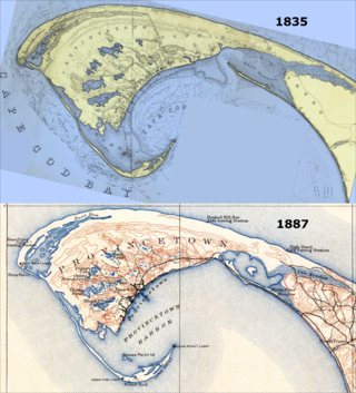
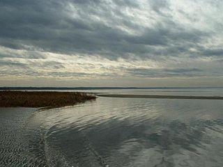
East Harbor is a tidal estuary in Truro, Massachusetts that was originally a natural harbor until it was cut off from Cape Cod Bay to form a salt marsh lagoon, later renamed Pilgrim Lake. It is now within the Cape Cod National Seashore.
Great Pond (Truro) is one of three ponds in Barnstable County that share the name. The others are located in Eastham and Provincetown. Great Pond in Truro is 17-acre natural kettle pond with an average depth of 14 feet (4.3 m) and a maximum depth of 35 feet (11 m). Transparency is very good, extending to 14 feet (4.3 m), and aquatic vegetation is scarce. The bottom is composed primarily of sand. The shoreline is lightly developed with residential homes.
