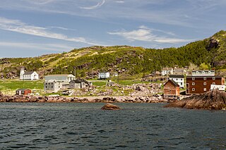
Newtown is a part of the Municipality of New-Wes-Valley, located at the North end of Bonavista Bay in the province of Newfoundland and Labrador, Canada. The approximate population is 400. Settlement in Newtown originated around 1850 when people relocated from nearby areas. Newtown is well known for being built on many small islands, and is the home of the Barbour Living Heritage Village.
Bonavista Bay (BB) is a large bay located on the northeast coast of the island of Newfoundland in the province of Newfoundland and Labrador in Canada. It opens directly onto the Atlantic Ocean.

Open Hall-Red Cliffe is a local service district and designated place in the Canadian province of Newfoundland and Labrador.
Upper Amherst Cove, is a local service district and designated place in the Canadian province of Newfoundland and Labrador.
Valleyfield, Newfoundland is a village and was served by the C.N.R. It joined the Rural District of Badger's Quay-Valleyfield-Pool's Island in April 1980 until 1992 when the District merged with other nearby towns to form New-Wes-Valley. Valleyfield has a good harbour, and is the location of the Beothic Fisheries fish plant.
Virgin Arm–Carter's Cove is a local service district and designated place on New World Island in the Canadian province of Newfoundland and Labrador. Virgin Arm-Carter's Cove is located approximately 90km Northwest of Gander in Subdivision H of Division No. 8.
Badger's Quay is a Canadian town in the province of Newfoundland and Labrador.
The Bonavista Peninsula is a large peninsula on the east coast of the island of Newfoundland in the Canadian province of Newfoundland and Labrador. It consists of 50 incorporated towns/unincorporated communities which have a population of 12,176 as of the 2016 Canadian Census. Bonavista is the largest population centre on the peninsula.
Cape Island is the name of both an island and a community in the Canadian province of Newfoundland and Labrador.
Deadman's Bayis a local service district and designated place in the Canadian province of Newfoundland and Labrador. It is on the Straight Shore of Bonavista Bay near the community of Lumsden. The community is located near fishing grounds, contributing to its diversified and successful fishery despite its exposed, sandy coastline and harsh fall storms.
Indian Bay is located in Newfoundland, Canada.
Flowers Island is one of the communities in an area on the northeast coast of the Island of Newfoundland called Bonavista North. These communities have a shared history in that they were settled by people from England, predominantly from the West Country—Dorset, Devon Somerset and Hampshire.
Cape Freels is one of the communities that comprise an area on the northeast coast of the Island of Newfoundland, called Bonavista North, in the province of Newfoundland and Labrador, Canada. These communities have a shared history in that they were settled by people from England, predominantly from the West Country - Dorset, Devon, Somerset and Hampshire.
Fair Island, also called Vere Island, is one of the communities that comprise an area on the northeast coast of the Island of Newfoundland, called Bonavista North. These communities have a shared history in that they were settled by people from England, predominantly from the West Country - Dorset, Devon Somerset and Hampshire.
Pinchard's Island was one of the communities that comprise an area on the northeast coast of the Island of Newfoundland, called Bonavista North. These communities have a shared history in that they were settled by people from England, predominantly from the West Country - Dorset, Devon Somerset and Hampshire.

Sop's Arm is a local service district and designated place in the Canadian province of Newfoundland and Labrador. The community was formed in the 1930s and 1940s by families moving from surrounding communities, including Jackson's Arm. In the 1950s and 1960s families from nearby Sop's Island moved to Sop's Arm, towing their houses across the channel of water.
Canning's Cove is a local service district and designated place in the Canadian province of Newfoundland and Labrador. It is on Bonavista Bay.

Birchy Cove is a local service district and designated place in the Canadian province of Newfoundland and Labrador.

Roberts Arm is a small town located near Crescent Lake, Newfoundland and Labrador, Canada in Division No. 8, Newfoundland and Labrador. It is found on the northern part of Newfoundland. Roberts Arm boasts of its Lake Monster, Cressie, which is claimed to be living in Crescent Lake. Recent years saw the development of a majestic hiking trail which encompasses the end of the lake nearest to the community, Hazelnut Adventure Trail.
Division No. 1, Subdivision L is an unorganized subdivision on the Avalon Peninsula in Newfoundland and Labrador, Canada. It is in Division 1 and contains the unincorporated communities of Bareneed, Black Duck Pond, Blow Me Down, Coley's Point South, Hibb's Cove, Pick Eyes, Port de Grave, Ship Cove and The Dock


