Salish tradition
According to Salish tradition, North Wind stretched a weir of ice across the Duwamish River at this site; no fish could pass, starving the people up the valley, the people of the Chinook Wind who was married to North Wind's daughter Mountain Beaver Woman. The mother of Mountain Beaver woman survived the starvation, but retreated to the mountain. Mountain Beaver Woman's son, the child Storm Wind, also survived. [2]

A weir or low head dam is a barrier across the width of a river that alters the flow characteristics of water and usually results in a change in the height of the river level. There are many designs of weir, but commonly water flows freely over the top of the weir crest before cascading down to a lower level.
The people of the North Wind warned Storm Wind to stay away from the mountain, trying to keep from him the knowledge of what had happened to his people, but eventually he defied them and found his grandmother living in misery. He heard her story and helped her out of her misery; she, in return, aided him with a flood that shattered the weir and turned it to stone. Storm Wind and his grandmother defeated North Wind, who only occasionally and briefly torments the area with snow and ice. [2]
The Muckleshoot are a Lushootseed-speaking Native American tribe, part of the Coast Salish peoples of the Pacific Northwest. They are descendants of the Duwamish and Puyallup peoples whose traditional territory was located along the Green and White rivers, including up to the headwaters in the foothills of the Cascade Mountains, in present-day Washington State. Since the mid-19th century, their reservation is located in the area of Auburn, Washington, about 15 miles northeast of the port of Tacoma and 35 miles southeast of Seattle, another major port.

The Duwamish are a Lushootseed-speaking Native American tribe in western Washington, and the indigenous people of metropolitan Seattle, where they have been living since the end of the last glacial period. The Duwamish tribe descends from at least two distinct groups from before intense contact with people of European ancestry—the People of the Inside and the People of the Large Lake —and continues to evolve both culturally and ethnically. By historic language, the Duwamish are (Skagit-Nisqually) Lushootseed; Lushootseed is a Salishan language. Adjacent tribes throughout the Puget Sound-Strait of Georgia basin were, and are, interconnected and interrelated, yet distinct. Today, some Duwamish people are enrolled in the federally recognized Tulalip Tribes of Washington.

Union Bay is a body of water located in Lake Washington, Seattle, Washington. The bay has the Laurelhurst neighborhood to the north and the Montlake and Madison Park neighborhoods to the south. The Evergreen Point Floating Bridge, which carries State Route 520, crosses over a portion of the bay.

The Hiram M. Chittenden Locks, or Ballard Locks, is a complex of locks at the west end of Salmon Bay, in Seattle, Washington's Lake Washington Ship Canal, between the neighborhoods of Ballard to the north and Magnolia to the south.
Lushootseed is the language or dialect continuum of several Salish Native American tribes of modern-day Washington state. Lushootseed is one of the Coast Salish languages. The latter is one of two main divisions of the Salishan language family.

West Seattle comprises two of the thirteen districts of the city of Seattle, Washington and encompasses all of Seattle west of the Duwamish River. It was incorporated as an independent town in 1902 before being annexed by Seattle five years later. Among the area's attractions are its saltwater beach parks along Elliott Bay and Puget Sound, including Alki Beach Park and Lincoln Park. The area is also known for its views of the Olympic Mountains to the west and the Cascade Range to the east. One-third of Seattle's green space and urban forest is located in West Seattle, much of it in the West Duwamish Greenbelt.
Coast Salish languages are a subgroup of the Salishan language family. These languages are spoken by First Nations or Native American peoples inhabiting the territory that is now the southwest coast of British Columbia around the Strait of Georgia and Washington state around Puget Sound. The term "Coast Salish" also refers to the cultures in British Columbia and Washington who speak one of these languages or dialects.

Northgate is a neighborhood in north Seattle, Washington, named for and surrounding Northgate Mall, the first covered mall in the United States.
Its east-west principal arterials are NE Northgate Way and 130th Street, and its north-south principal arterials are Roosevelt Way NE and Aurora Avenue N. Minor arterials are College Way-Meridian Avenue N, 1st, 5th, and 15th avenues NE. Interstate 5 runs through the district. Besides the eponymous mall, the most characteristic distinctions of the area are North Seattle College (NSC), the south fork of the Thornton Creek watershed, and the Idriss Mosque.

The Industrial District is the principal industrial area of Seattle, Washington. It is bounded on the west by the Duwamish Waterway and Elliott Bay, beyond which lies Delridge of West Seattle; on the east by Interstate 5, beyond which lies Beacon Hill; on the north by S King and S Dearborn Streets, beyond which lie Pioneer Square and southwest International District of Downtown; and on the south by the main lines of the BNSF Railway and Union Pacific Railroad, or about S Lucille Street, beyond which is Georgetown. SoDo is the name of the northwest portion of the neighborhood, named for its being South of Downtown. SoDo is the location of T-Mobile Park, home of the Seattle Mariners, and CenturyLink Field, home of the Seattle Seahawks and Seattle Sounders FC. CenturyLink Field was also the site of the former Kingdome.

Delridge is a district in West Seattle, Washington, United States that stretches along Delridge Way, an arterial that follows the eastern slope of the valley of Longfellow Creek, from near its source just within the southern city limits north to the West Seattle Bridge over the Duwamish River.

Matthews Beach is a neighborhood in Seattle, Washington; it and Meadowbrook are the southern neighborhoods of the annexed township of Lake City (1954). Matthews Beach lies about 2 miles (3 km) northeast of the University of Washington, about 8 miles (13 km) northeast of Downtown.
The Sammamish people were a Coast Salish Native American tribe in the Sammamish River Valley in central King County, Washington. Their name is variously translated as ssts'p-abc, s-tah-PAHBSH or as Samena, which was corrupted into Sammamish. According to Hitchman, it does not mean “hunter people”, the name is derived from samma, meaning “the sound of the blue crane” and mish, meaning “river.” The name may have originated with the Snoqualmie—some tribal members once lived along the lake near the bottom of Inglewood Hill—but this has not been verified. They were also known to early European-American settlers as "Squak", "Simump", and "Squowh.", Squak is a corruption of sqwa'ux, meaning Issaquah Creek, which was a village site on Sammamish Lake. They were closely related to the Duwamish, and have often been considered a Duwamish sub-group as part of the Xacuabš who lived near Lake Washington. Like the Duwamish, the Sammamish originally spoke a southern dialect of Lushootseed.

Meadowbrook is a neighborhood in the Lake City district of Seattle, Washington. Meadowbrook is centered on open fields adjacent to the Meadowbrook Community Center, swimming pool, and Nathan Hale High School. It is bounded on the south by NE 95th Street and the Wedgwood neighborhood, on the north by NE 120th Street and Cedar Park, on the west by Lake City Way NE and Victory Heights., and on the east by 35th Avenue NE and Matthews Beach. The neighborhood is almost entirely residential. There are no commercial strips, though there are some small restaurants and other businesses. The area is served by a number of public schools, including John Rogers Elementary, Jane Addams Middle School, and Nathan Hale High School.

Fauntleroy is a neighborhood in the southwest corner of Seattle, Washington. Part of West Seattle and situated on Puget Sound's Fauntleroy Cove, it faces Vashon Island, Blake Island, and the Kitsap Peninsula to the west. On sunny days, many locations in the neighborhood offer views of the Olympic Mountains, which are about 40 miles to the west. The neighborhood adjoins Lincoln Park to the north, Fauntlee Hills to the east, and Arbor Heights to the south. Within Fauntleroy is an area known as Endolyne. Fauntleroy is home to an eponymous Washington State Ferries terminal, providing service to Vashon Island and Southworth.
History of Seattle before white settlement
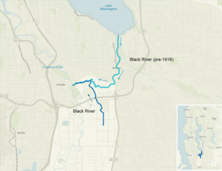
The Black River is a tributary of the Duwamish River in King County in the U.S. state of Washington. It drained Lake Washington until 1916, when the opening of the Lake Washington Ship Canal lowered the lake, causing part of the Black River to dry up. It still exists as a dammed stream about 2 miles (3.2 km) long.

Foster, Washington was a former community in King County in the U.S. state of Washington. Today, after being annexed in 1989, Foster's former area is a part of the city of Tukwila.

The Snoqualmie people (S·dukʷalbixʷ) are a southern Coast Salish indigenous people of the Pacific Northwest Coast. Their homelands span the Snoqualmie Valley in east King and Snohomish Counties in Washington state.


