
Appalachian Mountain Club (AMC) is the oldest outdoor group in the United States. Created in 1876 to explore and preserve the White Mountains in New Hampshire, it has expanded throughout the northeastern U.S., with 12 chapters stretching from Maine to Washington, D.C. The AMC's 275,000 members, advocates, and supporters mix outdoor recreation, particularly hiking and backpacking, with environmental activism. Additional activities include cross-country skiing, whitewater and flatwater canoeing and kayaking, sea kayaking, sailing, rock climbing and bicycle riding. The Club has about 2,700 volunteers, who lead roughly 7,000 trips and activities per year. The organization publishes a number of books, guides, and trail maps.
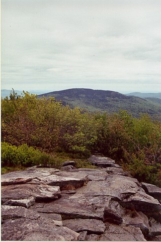
The Wapack Trail is one of the oldest public, interstate hiking trails in the United States. Opened in 1923, it follows the Wapack Range north-south for 21 miles (34 km), between Mount Watatic in Ashburnham, Massachusetts, and North Pack Monadnock mountain in Greenfield, New Hampshire. It is designed primarily for day use by hikers, with minimal camping facilities.

The protected areas of the United States are managed by an array of different federal, state, tribal and local level authorities and receive widely varying levels of protection. Some areas are managed as wilderness, while others are operated with acceptable commercial exploitation. As of 2022, the 42,826 protected areas covered 1,235,486 km2 (477,024 sq mi), or 13 percent of the land area of the United States. This is also one-tenth of the protected land area of the world. The U.S. also had a total of 871 National Marine Protected Areas, covering an additional 1,636,523 km2 (631,865 sq mi), or 19 percent of the total marine area of the United States.

The Midstate Trail is a scenic footpath which runs 92 miles (148 km) through Worcester County, Massachusetts, from the Rhode Island border to the New Hampshire border, approximately 45 miles (72 km) west of Boston. The trail is considered highly accessible, scenic, and remarkably rural despite its proximity to urban Boston. The trail includes the summits of Mount Wachusett and Mount Watatic, as well as many interesting geologic, historic, and natural features.
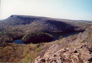
The Hanging Hills of south central Connecticut, United States are a range of mountainous trap rock ridges overlooking the city of Meriden and the Quinnipiac River Valley 900 feet (274 m) below. They are a sub-range of the narrow, linear Metacomet Ridge that extends from Long Island Sound near New Haven, Connecticut, north through the Connecticut River Valley of Massachusetts to the Vermont border. A popular outdoor recreation resource, the range is known for its microclimate ecosystems, rare plant communities, and expansive views from cliffs that rise abruptly over 700 feet (213 m) above the surrounding landscape. The Hanging Hills encompass the 1,800-acre (7.3 km2) Hubbard Park, designed with the help of landscape architect Frederick Law Olmsted. The 51 mile (80k) Metacomet Trail traverses the range.

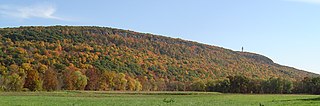
Mount Watatic is a 1,832-foot (558 m) monadnock located just south of the Massachusetts–New Hampshire border, in the United States, at the southern end of the Wapack Range. It lies in Ashburnham, Massachusetts and Ashby, Massachusetts. The 22-mile (35 km) Wapack Trail and the 92-mile (148 km) Midstate Trail both cross the mountain.
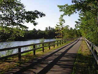
The Nashua River Rail Trail is a 12.5-mile (20.1 km) paved mixed-use rail trail in northern Massachusetts and southern New Hampshire under control of the Massachusetts Department of Conservation and Recreation (DCR). It roughly follows the course of the Nashua River, passing through the towns of Ayer, Groton, Pepperell, and Dunstable, Massachusetts and ends about a mile across the New Hampshire state border in Nashua, New Hampshire. The trail is used by walkers, cyclists, inline skaters, equestrians, and cross-country skiers.

Ragged Mountain, est. 761 feet (232 m), is a traprock mountain ridge located 3 miles (5 km) west of New Britain, Connecticut, in the towns of Southington and Berlin, Connecticut. It is part of the narrow, linear Metacomet Ridge that extends from Long Island Sound near New Haven, Connecticut, north through the Connecticut River Valley of Massachusetts to the Vermont border. The mountain, a popular hiking and rock climbing attraction located between metropolitan Hartford and Meriden, is known for expansive vistas, vertical cliff faces, mountain ridge reservoirs, unique microclimate ecosystems, and rare plant communities. Ragged Mountain is traversed by the 51-mile (82 km) Metacomet Trail.

The Trust for Public Land is a U.S. nonprofit organization with a mission to "create parks and protect land for people, ensuring healthy, livable communities for generations to come". Since its founding in 1972, the Trust for Public Land has completed 5,000 park-creation and land conservation projects across the United States, protected over 3 million acres, and helped pass more than 500 ballot measures—creating $70 billion in voter-approved public funding for parks and open spaces. The Trust for Public Land also researches and publishes authoritative data about parks, open space, conservation finance, and urban climate change adaptation. Headquartered in San Francisco, the organization is among the largest U.S. conservation nonprofits, with approximately 30 field offices across the U.S., including a federal affairs function in Washington, D.C.
Open Space Institute (OSI) is a conservation organization that protects land for clean drinking water, public recreation, healthy communities, wildlife habitat, and climate protection. Established in 1974, OSI achieves its goals through land acquisition, fiscal sponsorship, regional loan and grant programs, park and trail improvements, and public policy and advocacy. OSI is active across the country, including the states of New York, Vermont, New Hampshire, Maine, Georgia, South Carolina, Virginia, Tennessee, and New Jersey.
The Society for the Protection of New Hampshire Forests (SPNHF) is a private, non-profit, land conservation and sustainable forestry organization based in the U.S. state of New Hampshire. It purchases or is given easements on property, or obtains outright ownership, as a way to conserve land for wildlife, recreation, sustainable forestry and sustainable agriculture. It also performs advocacy and education services. It was established in February 1901, with Frank W. Rollins as its first president. Philip W. Ayres was appointed the first Forester. During the 1920s, the SPNHF raised over $100,000 towards the purchase of land in Franconia Notch.

The Wapack Wilderness is a 1,400-acre (6 km2) tract of forest in the towns of Rindge and New Ipswich, New Hampshire. The land is owned by the Hampshire Country School, a small, private school for students who do not thrive in traditional settings. It abuts Binney Pond Natural Area and land conserved by the New England Forestry Foundation. Watatic Mountain Wildlife Area is two miles (3 km) to the southeast, and Annett State Forest is two miles (3 km) to the northeast. The headwaters of the Millers River flow from the area, feeding into Converse Meadows and Lake Monomonac before entering Massachusetts.
Talcott Mountain of central Connecticut, with a high point of 950 feet (290 m), is a 13-mile (21 km) long trap rock mountain ridge located 6 miles (10 km) west of the city of Hartford. The ridge, a prominent landscape feature, forms a continuous line of exposed western cliffs visible across the Farmington River valley from Farmington to Simsbury. Talcott Mountain is part of the narrow, linear Metacomet Ridge that extends from Long Island Sound near New Haven, Connecticut, north through the Connecticut River Valley of Massachusetts to the Vermont border.

West Rock Ridge or West Rock of south-central Connecticut, is a 7-mile (11 km) long trap rock mountain ridge located on the west side of New Haven with a high point of 700 feet (213 m). The ridge forms a continuous line of exposed cliffs visible from metropolitan New Haven and points west. West Rock Ridge is part of the narrow, linear Metacomet Ridge which extends from Long Island Sound near New Haven north through the Connecticut River Valley of Massachusetts to the Vermont border.

Pratt Mountain is a 1,817 feet (554 m) summit within the Wapack Range of mountains in south-central New Hampshire, United States. It lies within the town of New Ipswich and is traversed by the 22 mi (35 km) Wapack Trail. The subordinate peak, Stony Top, 1,760 feet (540 m), forms the north shoulder of the mountain. Pratt Mountain offers expansive views from rocky ledges along its length.

The Taconic Crest Trail is a 37 mi (60 km) hiking trail in the Taconic Mountains in the northeastern United States. The trail extends from U.S. Route 20 in Hancock, Massachusetts, less than 1 mi (1.6 km) east of the New York border, north along the ridgecrest of the Taconic Range, first within Massachusetts, then weaving along the border of New York and Massachusetts and New York and Vermont, and ending in Petersburgh, New York, on NY Route 346, near the Vermont border. Much of the route has been conserved as state forest, conservation easement, or forest preserve.
Kennebec Estuary Land Trust (KELT) is a community-based organization in Maine involving members from Arrowsic, Bath, Bowdoinham, Dresden, West Bath, Georgetown, Westport Island, and Woolwich. KELT does their work through conservation easements, property donation and outright purchase. They collaborate with state and federal agencies and private conservation organizations within the Maine Wetlands Protection Coalition.

The Chebeague & Cumberland Land Trust is a volunteer-run conservation group based in Cumberland, Maine, United States. Established in 1987 and funded by its members, it owns many preserves and trail networks, and has assisted in the creation of town-owned parks and preserves. The trust, one of eighty land trusts in Maine, covers the towns of Cumberland and Chebeague Island.

The Maine Land Trust Network promotes discussion among the eighty land trusts in Maine, United States. It was established in 1995.
