Related Research Articles

The Cascade Range or Cascades is a major mountain range of western North America, extending from southern British Columbia through Washington and Oregon to Northern California. It includes both non-volcanic mountains, such as the North Cascades, and the notable volcanoes known as the High Cascades. The small part of the range in British Columbia is referred to as the Canadian Cascades or, locally, as the Cascade Mountains. The latter term is also sometimes used by Washington residents to refer to the Washington section of the Cascades in addition to North Cascades, the more usual U.S. term, as in North Cascades National Park. The highest peak in the range is Mount Rainier in Washington at 14,411 feet (4,392 m).
The Pacific Northwest (PNW), sometimes referred to as Cascadia, is a geographic region in western North America bounded by the Pacific Ocean to the west and (loosely) by the Rocky Mountains on the east. Though no official boundary exists, the most common conception includes the Canadian province of British Columbia (BC) and the U.S. states of Idaho, Oregon, and Washington. Broader conceptions reach north into Southeast Alaska and Yukon, south into northern California, and east to the Continental Divide to include Western Montana and parts of Wyoming. Narrower conceptions may be limited to the coastal areas west of the Cascade and Coast mountains. The variety of definitions can be attributed to partially overlapping commonalities of the region's history, culture, geography, society, and other factors.

Kennewick is a city in Benton County in the U.S. state of Washington, along the southwest bank of the Columbia River, just southeast of the confluence of the Columbia and Yakima rivers and across from the confluence of the Columbia and the Snake River. It is the most populous of the three cities collectively referred to as the Tri-Cities. The population was 73,917 at the 2010 census. July 1, 2018 estimates from the Census Bureau put the city's population at 82,943. The 2018 population estimate for the Tri-Cities metro area is 296,224, making it the fourth-largest metropolitan area in the state.

Mount Anderson is a 7,330-foot-high (2,234 m) peak in the Olympic Mountains of the Pacific Northwest. Rising in the center of Olympic National Park in Washington state, it is the second highest peak on the Anderson Massif, after West Peak. Anderson Glacier used to be located in a cirque on the mountain's southern flank while Eel Glacier is in another cirque, northwest of the summit. Hanging Glacier is on the east side of a ridge which extends north from the peak.

The Columbus Day Storm of 1962 was a Pacific Northwest windstorm that struck the West Coast of Canada and the Pacific Northwest coast of the United States on October 12, 1962. It is considered the benchmark of extratropical wind storms. The storm ranks among the most intense to strike the region since at least 1948, likely since the January 9, 1880 "Great Gale" and snowstorm. The storm is a contender for the title of most powerful extratropical cyclone recorded in the U.S. in the 20th century; with respect to wind velocity, it is unmatched by the March 1993 "Storm of the Century" and the "1991 Halloween Nor'easter". The system brought strong winds to the Pacific Northwest and southwest Canada, and was linked to 46 fatalities in the northwest and Northern California resulting from heavy rains and mudslides.
The Northwest Athletic Conference (NWAC), formerly called the Northwest Athletic Association of Community Colleges or NWAACC for short, is a sports association for community colleges in the U.S. states of Oregon, Washington and Idaho, along with the Canadian province of British Columbia.

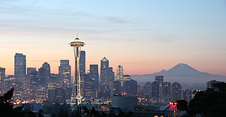
Washington, officially the State of Washington, is a state in the Pacific Northwest region of the United States. Named for George Washington, the first U.S. president, the state was made out of the western part of the Washington Territory, which was ceded by the British Empire in 1846, in accordance with the Oregon Treaty in the settlement of the Oregon boundary dispute. The state, which is bordered on the west by the Pacific Ocean, Oregon to the south, Idaho to the east, and the Canadian province of British Columbia to the north, was admitted to the Union as the 42nd state in 1889. Olympia is the state capital; the state's largest city is Seattle. Washington is often referred to as Washington State to distinguish it from the nation's capital, Washington, D.C..

Mount Hood climbing accidents are mountain climbing- or hiking-related incidents on Oregon's Mount Hood. As of 2007, about 10,000 people attempt to climb Mount Hood each year. As of May 2002, more than 130 people have died climbing Mount Hood since records have been kept. One of the worst climbing accidents occurred in 1986, when seven teenagers and two school teachers froze to death while attempting to retreat from a storm.

The Puget Sound region is a coastal area of the Pacific Northwest in the U.S. state of Washington, including Puget Sound, the Puget Sound lowlands, and the surrounding region roughly west of the Cascade Range and east of the Olympic Mountains. It is characterized by a complex array of saltwater bays, islands, and peninsulas carved out by prehistoric glaciers.
KRSB-FM is a radio station licensed to serve Roseburg, Oregon, United States. The station, established in 1970, is currently owned by Brooke Communications, Inc. The station gained worldwide attention in the 1970s for its "Goat Weather Forecasts" based on the movement of local wild goats.

The January 2012 Pacific Northwest snowstorm was a large extratropical cyclone that brought record snowfall to the Pacific Northwest in January 2012. The storm produced very large snowfall totals, reaching up to 50 inches (1,300 mm) in Oregon. A 110 mph (180 km/h) wind gust was reported at Otter Rock, Oregon. A mother and child were killed in Oregon after the car they were in slid into a creek, while a man was killed in the Seattle area. About 200,000 homes were without power in the Greater Seattle area after the storm.

The 2011–12 North American winter refers to winter in North America as it occurred across the continent from late 2011 through early 2012. The 2011–12 season by and large saw above normal average temperatures across North America, with the contiguous United States encountering its fourth-warmest winter on record along with an unusually low number of significant winter precipitation events. The primary outlier was Alaska, which experienced its coldest January on record.

Hinkhouse Peak is a 7,560-foot (2,300-metre) mountain summit located on the shared border of Okanogan County and Chelan County in Washington state. It is part of the Okanogan Range which is a sub-range of the North Cascades Range. Hinkhouse Peak is situated on land administered by Okanogan National Forest. The nearest higher peak is Liberty Bell Mountain, 1.52 miles (2.45 km) to the south. Hinkhouse Peak is situated north of Washington Pass, at the east end of a high ridge which connects to Cutthroat Peak. A high ridge extending southeast connects it to Constitution Crags. Most precipitation runoff from the peak drains into Early Winters Creek which is a tributary of the Methow River, but the south slope drains into a tributary of the Chelan River.

Mount Fremont is a 7,317 feet (2,230 m) summit located in Mount Rainier National Park in Pierce County of Washington state. It is part of the Sourdough Mountains, a subset of the Cascade Range. Mount Fremont is situated northwest of the Sunrise Historic District, with a popular trail leading to the Mount Fremont Fire Lookout. However, this trail does not reach the true summit, and access is further limited by snowpack closing the Sunrise Road much of the year. July, August, and September are typically the months when the Sunrise Road is seasonally open for vehicle traffic. Second Burroughs Mountain is its nearest higher peak, 1.31 mi (2.11 km) to the southwest. Precipitation runoff from Mount Fremont drains into the White River.

Yakima Peak is a 6,226 feet (1,898 m) summit located on the eastern border of Mount Rainier National Park. It is also on the shared border of Pierce County and Yakima County in Washington state. Yakima Peak is situated northwest of Tipsoo Lake and west of Chinook Pass on the crest of the Cascade Range. Its nearest higher peak is Deadwood Peak, 0.59 mi (0.95 km) to the north. The name Yakima Peak honors the Yakima Tribe of eastern Washington state. From Chinook Pass, a short scramble up a gully on the north side leads to a flat summit with unobstructed views of Mount Rainier and Naches Peak.

Tamanos Mountain is a 6,790 feet (2,070 m) summit located in Mount Rainier National Park in Pierce County of Washington state. It is part of the Cascade Range. Tamanos Mountain is situated west of Governors Ridge and northeast of the Cowlitz Chimneys, all of which can be seen from the Sunrise Historic District. The name tamanos derives from Chinook Jargon and has the meaning of guardian spirit. The normal climbing access is from the Owyhigh Lakes Trail, and from the lakes scramble up the south slope to the summit.
Sluiskin Mountain is a prominent pair of summits located in Mount Rainier National Park in Pierce County of Washington state. It is situated northwest of Burroughs Mountain and is part of the Cascade Range. The higher rocky peak is known as The Chief (7026 ft), and the second peak to the west is known as The Squaw. West of The Squaw are pinnacles called The Papooses. Sluiskin was the native American guide who assisted with the first successful ascent of Mount Rainier by Hazard Stevens and P. B. Van Trump in 1870. Sluiskin Falls within the park also honors him.

Cowlitz Chimneys are a group of four rhyolite towers located in Mount Rainier National Park in Pierce County of Washington state. As part of the Cascade Range, the Cowlitz Chimneys are situated southwest of Tamanos Mountain and east of Banshee Peak, all of which are visible from the Sunrise Historic District. The Sarvant Glacier is set on the north aspect of these remnants of a volcanic plug. Cowlitz is the name of several geographical features in Mount Rainier National Park, as well as the state of Washington. The name appeared as early as the Lewis and Clark journals of 1805 when it was written as "Cowliskee" and has the Chinook Jargon meaning of "capturing the medicine spirit".

Warrior Peak is a 7,320+ ft double summit mountain located in Olympic National Park in Jefferson County of Washington state. Warrior is the 11th highest peak in the Olympic Mountains Range. The southeast summit is the slightly higher of the two summits, the northwest peak is estimated at 7285 feet elevation. Warrior Peak is easy to identify from Seattle, since it appears as the first prominent peak immediately north of Mount Constance, which is the dominant peak on the skyline. Warrior's nearest higher peak is in fact Mount Constance, 0.8 mi (1.3 km) to the south-southeast. The first ascent of the mountain was made in 1945 by Fred Beckey, who solo climbed both summits, and named the mountain.
Green Mountain is a 4,824-foot (1,470-metre) mountain summit located in King County of Washington state. It's situated at the western edge of the Cascade Range on land managed by Mount Baker-Snoqualmie National Forest. Green Mountain is more notable for its large, steep rise above local terrain than for its absolute elevation. Its nearest neighbor is Mount Teneriffe, 1.18 miles (1.90 km) to the southwest, and the nearest higher peak is Moolock Mountain, 2.48 miles (3.99 km) to the northeast. Precipitation runoff from Green Mountain drains into tributaries of the Snoqualmie River.
References
- 1 2 3 Laskin, David (Nov 21, 2011). "The Most Treacherous Terrain". SeattleMet. Retrieved 3 January 2013.
- ↑ "Northwest Weather and Avalanche Center" . Retrieved 3 January 2013.
- ↑ "Northwest Avalanche Accident Summaries" . Retrieved 2020-02-22.
- ↑ "About us" . Retrieved 2020-02-22.
- ↑ Tsong, Nicole (December 14, 2012). "Be ready for an avalanche before there is one". The Seattle Times. Retrieved 3 January 2013.
- ↑ Branch, John (20 December 2012). "Snow Fall". New York Times . Retrieved 24 December 2012.