Amherst is a city in Hampshire County, Massachusetts, United States, in the Connecticut River valley. Amherst has a council–manager form of government, and is considered a city under Massachusetts state law. Amherst is one of several Massachusetts municipalities that have city forms of government but retain "The Town of" in their official names. At the 2020 census, the population was 39,263, making it the highest populated municipality in Hampshire County. The town is home to Amherst College, Hampshire College, and the University of Massachusetts Amherst, three of the Five Colleges.

Deerfield is a town in Franklin County, Massachusetts, United States. Settled near the Connecticut River in the 17th century during the colonial era, the population was 5,090 as of the 2020 census. Deerfield is part of the Springfield, Massachusetts Metropolitan Statistical Area in western Massachusetts, lying 30 miles (48 km) north of the city of Springfield.

Hadley is a town in Hampshire County, Massachusetts, United States. The population was 5,325 at the 2020 census. It is part of the Springfield, Massachusetts Metropolitan Statistical Area. The area around the Hampshire and Mountain Farms Malls along Route 9 is a major shopping destination for the surrounding communities.

The city of Northampton is the county seat of Hampshire County, Massachusetts, United States. As of the 2020 census, the population of Northampton was 29,571.

The Pioneer Valley is the colloquial and promotional name for the portion of the Connecticut River Valley that is in Massachusetts in the United States. It is generally taken to comprise the three counties of Hampden, Hampshire, and Franklin. The lower Pioneer Valley corresponds to the Springfield, Massachusetts metropolitan area, the region's urban center, and the seat of Hampden County. The upper Pioneer Valley region includes the smaller cities of Northampton and Greenfield, the county seats of Hampshire and Franklin counties, respectively.

Greenfield is the only city in, and the seat of, Franklin County, Massachusetts, United States. Greenfield was first settled in 1686. The population was 17,768 at the 2020 census. Greenfield is home to Greenfield Community College, the Pioneer Valley Symphony Orchestra, and the Franklin County Fair. The city has a Main Street Historic District containing fine examples of Federal, Greek Revival, and Victorian architecture.

Granby is a town in Hampshire County, Massachusetts, United States. The population was 6,110 at the 2020 census. It is part of the Springfield, Massachusetts Metropolitan Statistical Area. The census-designated place of Granby corresponds to the main village of Granby in the center of the town.
Hatfield is a town in Hampshire County, Massachusetts, United States. The population was 3,352 at the 2020 census. It is part of the Springfield, Massachusetts Metropolitan Statistical Area. The census-designated place of Hatfield consists of the town center and surrounding areas.

Western Massachusetts, known colloquially as "western Mass," is a region in Massachusetts, one of the six U.S. states that make up the New England region of the United States. Western Massachusetts has diverse topography; 22 colleges and universities including UMass in Amherst, MA, with approximately 100,000 students; and such institutions as Tanglewood, the Springfield Armory, and Jacob's Pillow.

William Pynchon was an English colonist and fur trader in North America best known as the founder of Springfield, Massachusetts. He was also a colonial treasurer, original patentee of the Massachusetts Bay Colony, and the iconoclastic author of the New World's first banned book.
The Central Massachusetts Railroad was a railroad in Massachusetts. The eastern terminus of the line was at North Cambridge Junction where it split off from the Middlesex Central Branch of the Boston and Lowell Railroad in North Cambridge and through which it had access to North Station in Boston. From there, the route ran 98.77 miles west through the modern-day towns of Belmont, Waltham, Weston, Wayland, Sudbury, Hudson, Bolton, Berlin, Clinton, West Boylston, Holden, Rutland, Oakham, Barre, New Braintree, Hardwick, Ware, Palmer, Belchertown, Amherst, and Hadley to its western terminal junction at N. O. Tower in Northampton with the Connecticut River Railroad.

The Mass Central Rail Trail (MCRT) is a partially completed rail trail between Northampton, Massachusetts and Boston along the former right-of-way (ROW) of the Massachusetts Central Railroad. It currently has 59 miles (95 km) open, and 94.5 miles (152.1 km) are open or protected for trail development. When complete, it will be 104 miles (167 km) long through Central Massachusetts and Greater Boston, forming the longest rail trail in New England. Many sections of the trail, including the Norwottuck Branch of the Mass Central Rail Trail and the Somerville Community Path, have been developed as separate projects but serve as part of the complete Mass Central Rail Trail. The Norwottuck Network, a 501(c)(3) nonprofit that supports the build and operation of the MCRT, maintains interactive maps of the MCRT and rail trails that connect with the MCRT, and other Massachusetts trails.
The Calvin Coolidge Memorial Bridge is a major crossing of the Connecticut River in Western Massachusetts, connecting the towns of Northampton and Hadley. The bridge carries Route 9 across the river, where it connects to Interstate 91.

The Pocomtuc were a Native American tribe historically inhabiting western areas of Massachusetts.

The Norwottuck Branch Rail Trail, full name the Norwottuck Branch of the Mass Central Rail Trail, formerly the Norwottuck Rail Trail, is an 11-mile (18 km) combination bicycle/pedestrian paved rail trail running from Northampton, Massachusetts, through Hadley and Amherst, to Belchertown, Massachusetts. It opened in 1993, and is now part of the longer Mass Central Rail Trail.

The Metacomet Ridge, Metacomet Ridge Mountains, or Metacomet Range of southern New England is a narrow and steep fault-block mountain ridge known for its extensive cliff faces, scenic vistas, microclimate ecosystems, and rare or endangered plants. The ridge is an important recreation resource located within 10 miles (16 km) of more than 1.5 million people, offering four long-distance hiking trails and over a dozen parks and recreation areas, including several historic sites. It has been the focus of ongoing conservation efforts because of its natural, historic, and recreational value, involving municipal, state, and national agencies and nearly two dozen non-profit organizations.

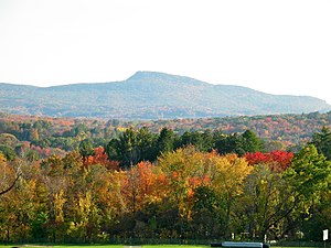
Mount Norwottuck or Mount Norwottock, 1,106 feet (337 m) above sea level, is the highest peak of the Holyoke Range of traprock mountains located in the Connecticut River Valley of Massachusetts and part of the greater Metacomet Ridge which stretches from Long Island Sound to nearly the Vermont border. The peak rises steeply from the valley 1,000 feet (300 m) below and offers sweeping views of the surrounding countryside. It is located within the towns of Amherst and Granby, Massachusetts.

The Robert Frost Trail is a 47-mile (76 km) long footpath that passes through the eastern Connecticut River Valley of Massachusetts. The trail runs from the Connecticut River in South Hadley, Massachusetts to Ruggles Pond in Wendell State Forest, through both Hampshire and Franklin County and includes a number of scenic features such as the Holyoke Range, Mount Orient, Puffer's Pond, and Mount Toby. The trail is named after the poet Robert Frost, who lived and taught in the area from 1916 to 1938.

The Battle of Bloody Brook was fought on September 28, 1675 between an indigenous war party primarily composed of Pocumtuc warriors and other local indigenous people from the central Connecticut River valley, and the English colonial militia of the New England Confederation and their Mohegan allies during King Philip's War.
The siege of Springfield was a siege of the colonial New England settlement of Springfield in 1675 by Native Americans during King Philip's War. Springfield was the second colonial settlement in New England to be burned to the ground during the war, following Providence Plantations. King Philip's War remains, per capita, the bloodiest war in American history.