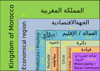
In Morocco, the 75 second-level administrative subdivisions are 13 prefectures and 62 provinces. They are subdivisions of the 12 regions of Morocco. Each prefecture or province is subdivided into arrondissements, municipalities or urban municipalities in other urban areas, and districts in rural areas. The districts are subdivided into rural municipalities. One prefecture (Casablanca) is also subdivided into préfectures d'arrondissements, similar to districts (cercles) except they are grouping a few arrondissements instead of rural municipalities.

San Vicente de Alcántara is a municipality in the province of Badajoz, Extremadura, Spain. It has a population of 5,788 and an area of 275 km².
Sefrou is one of the provinces of the Fès-Meknès region of Morocco. It had a population of 259,577 as per the Census Report of 2004.
Benslimane in a province of Morocco in the Casablanca-Settat Region. The province had a population of around 199,612 people in 2004 and covers an area of around 2,760 km².
Settat is a province of Morocco in the Casablanca-Settat Region. The province had a population of 956,904 people in 2004.
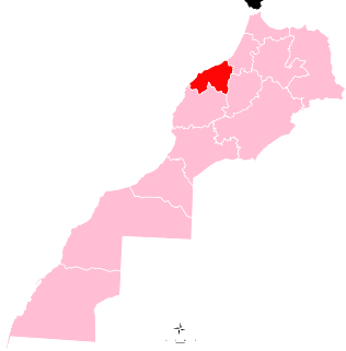
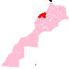
Khémisset is a province in the Moroccan economic region of Rabat-Salé-Kénitra. Its population in 2004 is 521,815 This town was founded in 1924 on the site of a military outpost on the road from Rabat to Fes now a provincial capital Khemisset is also the capital of the confederation of the Berber-speaking Zemmour tribes. This is a good place to stop since there are many cafes and restaurants .The town also has a crafts cooperative where you can buy regional specialities, such as carpets and mats woven in palm fibre or wool. Every Tuesday Khemisset is the venue for one of the most important country souks in Morocco, with almost 1900 stalls The major cities and towns are:
Médiouna is a province in the Moroccan region of Casablanca-Settat. Its population in 2004 was 122,851.
El Hajeb is a province in the Moroccan economic region of Fès-Meknès. Its population in 2004 was 216,388
Setti Fatma is a small town and rural commune in Al Haouz Province of the Marrakesh-Tensift-El Haouz region of Morocco. At the time of the 2004 census, the commune had a total population of 22283 people living in 3503 households.
Ait Makhlouf is a small town and rural commune in Taroudant Province of the Souss-Massa-Drâa region of Morocco. At the time of the 2004 census, the commune had a total population of 5285 people living in 1001 households.
Lakhzazra is a small town and rural commune in Settat Province of the Chaouia-Ouardigha region of Morocco. At the time of the 2004 census, the commune had a total population of 8673 people living in 1345 households.
Oued Naanaa is a small town and rural commune in Settat Province of the Chaouia-Ouardigha region of Morocco. At the time of the 2004 census, the commune had a total population of 7126 people living in 1158 households.
Oulad Chbana is a small town and rural commune in Settat Province of the Chaouia-Ouardigha region of Morocco. At the time of the 2004 census, the commune had a total population of 7925 people living in 1195 households.
Sidi Dahbi is a small town and rural commune in Settat Province of the Chaouia-Ouardigha region of Morocco. At the time of the 2004 census, the commune had a total population of 8367 people living in 1415 households.
Sidi Hajjaj is a small town and rural commune in Settat Province of the Chaouia-Ouardigha region of Morocco. At the time of the 2004 census, the commune had a total population of 18687 people living in 2741 households.
Dar Chaffai is a small town and rural commune in the Settat Province of the Chaouia-Ouardigha region of Morocco. At the time of the 2004 census, the commune had a total population of 17632 people living in 2399 households.
Sidi El Aidi is a small town and rural commune in Settat Province of the Chaouia-Ouardigha region of Morocco. At the time of the 2004 census, the commune had a total population of 13273 people living in 2226 households.
Oulad Sbih is a small town and rural commune in El Kelâat Es-Sraghna Province of the Marrakesh-Tensift-El Haouz region of Morocco. At the time of the 2004 census, the commune had a total population of 6131 people living in 970 households.