Naukati Bay is a census-designated place (CDP) in the Prince of Wales-Hyder Census Area of the Unorganized Borough of the U.S. state of Alaska. The population was 113 at the 2010 census, down from 135 in 2000.
The Fox Islands are a group of islands in the eastern Aleutian Islands of the U.S. state of Alaska. The Fox Islands are the closest to mainland North America in the Aleutian chain, and just east of Samalga Pass and the Islands of Four Mountains group.

The Gulf of Alaska is an arm of the Pacific Ocean defined by the curve of the southern coast of Alaska, stretching from the Alaska Peninsula and Kodiak Island in the west to the Alexander Archipelago in the east, where Glacier Bay and the Inside Passage are found.

William Healey Dall was an American naturalist, a prominent malacologist, and one of the earliest scientific explorers of interior Alaska. He described many mollusks of the Pacific Northwest of North America, and was for many years America's preeminent authority on living and fossil mollusks.

The Alexander Archipelago is a 300-mile (480 km) long archipelago in North America lying off the southeastern coast of Alaska. It contains about 1,100 islands, the tops of submerged coastal mountains that rise steeply from the Pacific Ocean. Deep channels and fjords separate the islands and cut them off from the mainland. The islands shelter the northern part of the Inside Passage as it winds its way among them.
The Shumagin Islands are a group of 20 islands in the Aleutians East Borough south of the mainland of Alaska, United States, at 54°54'–55°20' North 159°15'–160°45' West. The largest islands are Unga Island, Popof Island, Korovin Island, and Nagai Island. Other islands include Andronica, Big Koniuji, Little Koniuji, Simeonof, Chernabura, and Bird. The total land area is 1,192.369 km2 and their total population as of the 2020 census was 578 persons, almost entirely in the city of Sand Point, on Popof Island.

Cape Saint Elias is a cape in the U.S. state of Alaska. It is located at the southwest end of Kayak Island, 104 km (65 mi) southeast of Cordova, at 59°48′27″N144°35′12″W. It is commonly believed that Mount Saint Elias, the second highest mountain in the United States and Canada, is named for this landform.
Kayak Island, is located in the Gulf of Alaska, 100 km (62 mi) SE of Cordova, Alaska Malaspina Coastal Plain, on the eastern edge of Chugach National Forest. It has a land area of 73.695 km2 (28.454 sq mi) and no population. It is historically significant as the first place a non-native first set foot on Alaska, and thus chosen in 1978 for the location of the commemorative Bering Expedition Landing Site.

Hagemeister Island is an uninhabited island in the U.S. state of Alaska, located on the north shore of Bristol Bay at the entrance to Togiak Bay.
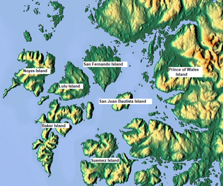
Suemez Island is located in the Alexander Archipelago of southeastern Alaska, United States. It resides in the west-central coast of Prince of Wales Island. The northern tip of Dall Island lies to its southeast, while Baker Island lies to its northwest. Suemez Island has a land area of 151.713 km2 and was unpopulated at the 2000 census.
Hall Island is a small island located 3.5 miles (5.6 km) to the northwest of St. Matthew Island in the Bering Sea in Alaska, United States. It serves as a haulout site for Pacific walrus. It is 5 miles (8 km) in length and has a land area of 6.2 square miles (16 km2). The highest point is 1,610 feet (490 m). Hall Island is uninhabited. It is part of the Bering Sea unit of the Alaska Maritime National Wildlife Refuge and is protected as part of the Bering Sea Wilderness.

Nagai Island is one of the largest of the Shumagin Islands in the Gulf of Alaska, south of the Alaska Peninsula considered a part of the NE Aleutian Range. It is located in the United States state of Alaska at 55°05′N160°01′W, and is 31 miles (50 km) long.
Bucareli Bay is a bay in the Alexander Archipelago, in the southeastern part of the U.S. state of Alaska. It is located off the western coast of Prince of Wales Island, between Baker Island and Suemez Island. To the east it connects to various waterways, such as San Alberto Bay. To the west it opens directly upon the Pacific Ocean. Bucareli Bay is about 25 miles (40 km) long.
Besboro Island is a small island in the Norton Sound, Bering Sea, off the shores of Alaska. It is located 11 miles (18 km) west of the mainland and 38 miles (61 km) southwest of Christmas Mountain, Nulato Hills.

Heceta Island is an island in the Alexander Archipelago of southeastern Alaska, United States. It lies just off the west coast of Prince of Wales Island. Kosciusko Island lies to its north, while Tuxekan Island lies to its northeast. Directly to its south are the Maurelle Islands group, while further south are Noyes Island, Lulu Island, and San Fernando Island. The island's area is 181.0 km2.
Baker Island is an island in the Alexander Archipelago of southeastern Alaska, United States. It lies off the central west coast of Prince of Wales Island. Its closest significant island neighbors are Noyes Island to its northwest, Lulu Island directly to its north, and Suemez Island across Bucareli Bay to its southeast. The smaller San Juan Bautista Island and St. Ignace Island separate it from Prince of Wales Island and its nearest community, Craig. The island has a land area of 44.44 square miles (115.1 km2) and is uninhabited.
Pyotr Kuzmich Krenitsyn, spelt "Krenitzin" in the United States, was a Russian explorer and Captain/Lieutenant of the Imperial Russian Navy. Following Vitus Bering's 1741 tragic venture he was the first to conduct an expedition to Alaska and the Aleutians. Krenitsyn was sent, together with Mikhail Levashev, by Russian Empress Catherine II to explore the northern parts of the Pacific Ocean and particularly the area around the Bering Strait in four ships. Krenitsyn was the commander of the ship St. Catherine and Levashev commanded the ship St. Paul.

USC&GS Yukon was a schooner that served as a survey ship from 1878 to 1894 in the United States Coast Survey, which was renamed the United States Coast and Geodetic Survey in 1878. She was the pioneering Coast Survey or Coast and Geodetic Survey ship in many of the waters of the Territory of Alaska, including the Bering Sea and the western Aleutian Islands, and she also operated extensively in California and Washington. She later entered commercial service as Elwood and was wrecked in 1895.

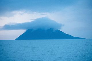
Buldir Volcano is an inactive stratovolcano located on Buldir Island in the Aleutian Islands of Alaska, once described as "the westernmost volcanic center of the present Pleistocene to Recent Aleutian volcanic front." It shares the island with a younger stratovolcano named East Cape.

The Aleutian Islands —also called the Aleut Islands, Aleutic Islands, or, before 1867, the Catherine Archipelago—are a chain of 14 main, larger volcanic islands and 55 smaller ones. Most of the Aleutian Islands belong to the U.S. state of Alaska, with the archipelago encompassing the Aleutians West Census Area and the Aleutians East Borough. The Commander Islands, located further to the west, belong to the Russian federal subject of Kamchatka Krai, of the Russian Far East. The islands form part of the Aleutian Arc of the Northern Pacific Ocean, and occupy a land area of 6,821 sq mi (17,666 km2) that extends westward roughly 1,200 mi (1,900 km) from the Alaskan Peninsula mainland, in the direction of the Kamchatka Peninsula; the archipelago acts as a border between the Bering Sea to the north and the Pacific Ocean to the south. Crossing longitude 180°, at which point east and west longitude end, the archipelago contains both the westernmost and easternmost parts of the United States, by longitude. The westernmost U.S. island, in real terms, however, is Attu Island, east of which runs the International Date Line.
