The Nubian languages are a group of related languages spoken by the Nubians. They form a branch of the Eastern Sudanic languages, which is part of the wider Nilo-Saharan phylum. Initially, Nubian languages were spoken throughout much of Sudan, but as a result of Arabization they are today mostly limited to the Nile Valley between Aswan and Al Dabbah as well as villages in the Nuba mountains and Darfur.
Nubians are an ethno-linguistic group of people who are indigenous to the region which is now northern Sudan and southern Egypt. They originate from the early inhabitants of the central Nile valley, believed to be one of the earliest cradles of civilization. They speak Nubian languages, part of the Northern Eastern Sudanic languages.
Nobiin, or Mahas, is a Northern Nubian language of the Nilo-Saharan language family. "Nobiin" is the genitive form of Nòòbíí ("Nubian") and literally means "(language) of the Nubians". Another term used is Noban tamen, meaning "the Nubian language".

The Ruzizi is a river, 117 kilometres (73 mi) long, that flows from Lake Kivu to Lake Tanganyika in Central Africa, descending from about 1,500 metres (4,900 ft) to about 770 metres (2,530 ft) above sea level over its length. The steepest gradients occur over the first 40 kilometres (25 mi), where hydroelectric dams have been built. Further downstream, the Ruzizi Plain, the floor of the Western Rift Valley, has only gentle hills, and the river flows into Lake Tanganyika through a delta, with one or two small channels splitting off from the main channel.

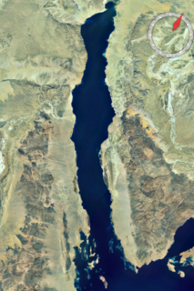
Toshka Lakes is the name given to recently formed endorheic lakes in the Sahara Desert of Egypt.
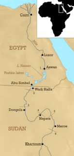
The Cataracts of the Nile are shallow lengths of the Nile River, between Khartoum and Aswan, where the surface of the water is broken by many small boulders and stones jutting out of the river bed, as well as many rocky islets. In some places, these stretches are punctuated by whitewater, while at others the water flow is smoother but still shallow.
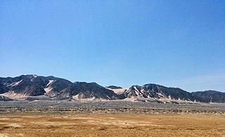
Itbāy or ʿAtbāy is a region of southeastern Egypt and northeastern Sudan. It is characterized by a chain of mountains, the Red Sea Hills, running north–south and parallel with the Red Sea. The hills separate the narrow coastal plain from the Eastern Desert.
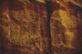
The Sahara pump theory is a hypothesis that explains how flora and fauna migrated between Eurasia and Africa via a land bridge in the Levant region. It posits that extended periods of abundant rainfall lasting many thousands of years in Africa are associated with a "wet-green Sahara" phase, during which larger lakes and more rivers existed. This caused changes in the flora and fauna found in the area. Migration along the river corridor was halted when, during a desert phase 1.8–0.8 million years ago (mya), the Nile ceased to flow completely and possibly flowed only temporarily in other periods due to the geologic uplift of the Nile River region.

The Azores Triple Junction (ATJ) is a geologic triple junction where the boundaries of three tectonic plates intersect: the North American Plate, the Eurasian Plate and the African Plate. This triple junction is located along the Mid-Atlantic Ridge (MAR) amidst the Azores islands, nearly due west of the Strait of Gibraltar. It is classed as a R-R-R triple junction of the T type, as it is an intersection of the Mid-Atlantic Ridge running north–south and the Terceira Rift which runs east-southeast.

The Afar Triple Junction is located along a divergent plate boundary dividing the Nubian, Somali, and Arabian plates. This area is considered a present-day example of continental rifting leading to seafloor spreading and producing an oceanic basin. Here, the Red Sea Rift meets the Aden Ridge and the East African Rift. It extends a total of 6,500 kilometers (4,000 mi) in three arms from the Afar Triangle to Mozambique.
The Gulf of Suez Rift is a continental rift zone that was active between the Late Oligocene and the end of the Miocene. It represented a continuation of the Red Sea Rift until break-up occurred in the middle Miocene, with most of the displacement on the newly developed Red Sea spreading centre being accommodated by the Dead Sea Transform. During its brief post-rift history, the deepest part of the remnant rift topography has been filled by the sea, creating the Gulf of Suez.

Nubia is a region along the Nile river encompassing the area between the first cataract of the Nile and the confluence of the Blue and White Niles, or more strictly, Al Dabbah. It was the seat of one of the earliest civilizations of ancient Africa, the Kerma culture, which lasted from around 2500 BC until its conquest by the New Kingdom of Egypt under Pharaoh Thutmose I around 1500 BC, whose heirs ruled most of Nubia for the next 400 years. Nubia was home to several empires, most prominently the Kingdom of Kush, which conquered Egypt in the eighth century BC during the reign of Piye and ruled the country as its 25th Dynasty.

The Kingdom of Kush was an ancient kingdom in Nubia, centered along the Nile Valley in what is now northern Sudan and southern Egypt.
Egypt has a long and involved demographic history. This is partly due to the territory's geographical location at the crossroads of several major cultural areas: North Africa, the Middle East, the Mediterranean and Sub-Saharan Africa. In addition, Egypt has experienced several invasions during its long history, including by the Canaanites, the Ancient Libyans, the Assyrians, the Kushites, the Persians, the Greeks, the Romans, and the Arabs.
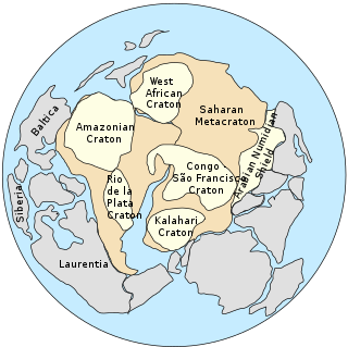
The Saharan Metacraton is a term used by some geologists to describe a large area of continental crust in the north-central part of Africa. Whereas a craton is an old and stable part of the lithosphere, the term "metacraton" is used to describe a craton that has been remobilized during an orogenic event, but where the characteristics of the original craton are still identifiable. The geology of the continent has only been partially explored, and other names have been used to describe the general area that reflect different views of its nature and extent. These include "Nile Craton", "Sahara Congo Craton", "Eastern Saharan Craton" and "Central Saharan Ghost Craton". This last term is because the older rocks are almost completely covered by recent sediments and desert sands, making geological analysis difficult.

The Blue Nile rift is a major geological formation in the Sudan, a rift with a NW trend that terminates on the Central African Shear Zone. It was formed through crustal extension during the break-up of Gondwana.

The Lwandle Plate is one of three tectonic microplates, along with the Rovuma Plate and Victoria Plate, that make up the African Plate with the Somali Plate and the Nubian Plate. Its discovery is very recent, so the velocity of the plate is neither well known nor well understood. Many experiments are ongoing to quantify this. The Lwandle Plate lies between 30°E and 50°E, sharing a boundary with the Nubian, Somali, and Antarctic Plates.
The geology of South Africa is highly varied including cratons, greenstone belts, large impact craters as well as orogenic belts. The geology of the country is the base for a large mining sector that extracts gold, diamonds, iron and coal from world-class deposits. The geomorphology of South Africa consists of a high plateau rimmed to west, south and southeast by the Great Escarpment, and the rugged mountains of the Cape Fold Belt. Beyond this there is strip of narrow coastal plain.
River incision is the narrow erosion caused by a river or stream that is far from its base level. River incision is common after tectonic uplift of the landscape. Incision by multiple rivers result in a dissected landscape, for example a dissected plateau. River incision is the natural process by which a river cuts downward into its bed, deepening the active channel. Though it is a natural process, it can be accelerated rapidly by human factors including land use changes such as timber harvest, mining, agriculture, and road and dam construction. The rate of incision is a function of basal shear-stress. Shear stress is increased by factors such as sediment in the water, which increase its density. Shear stress is proportional to water mass, gravity, and WSS:
The African Surface or African Erosion Surface is a land surface formed by erosion covering large swathes of Africa. The type area of the surface lies in South Africa where the surface was first identified as such by Lester Charles King in the mid-20th century.
