
The Arctic Archipelago, also known as the Canadian Arctic Archipelago, is an archipelago lying to the north of the Canadian continental mainland, excluding Greenland and Iceland
Compton Township is a township in Otter Tail County, Minnesota, United States. The population was 799 at the 2000 census.

Bowers Mountains is a group of north–south trending mountains in Antarctica, about 90 nautical miles long and 35 nautical miles wide, bounded by the coast on the north and by the Rennick Glacier, Canham Glacier, Black Glacier and Lillie Glacier in other quadrants. They are west of the Usarp Mountains, north of the Freyberg Mountains, northeast of the Concord Mountains, east of the Anare Mountains.
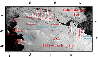
The Abbot Ice Shelf is an ice shelf 250 nautical miles long and 40 nautical miles wide, bordering Eights Coast from Cape Waite to Pfrogner Point in Antarctica. Thurston Island lies along the northern edge of the western half of this ice shelf; other sizable islands lie partly or wholly within this shelf.

The Getz Ice Shelf is an ice shelf over 300 nautical miles long and from 20 to 60 nautical miles wide, bordering the Hobbs Coast and Bakutis Coast of Marie Byrd Land, Antarctica, between the McDonald Heights and Martin Peninsula. Several large islands are partially or wholly embedded in the ice shelf.

Galindez Island is an island 0.5 nautical miles long, lying immediately east of Winter Island in the Argentine Islands, Wilhelm Archipelago, Antarctica. It is home to the Vernadsky Research Base.
Athos Range is the northernmost range in the Prince Charles Mountains of Mac. Robertson Land, Antarctica. The range consists of many individual mountains and nunataks that trend east–west for 40 miles (64 km) along the north side of Scylla Glacier.
Avsyuk Glacier is a glacier on Arrowsmith Peninsula, Graham Land, flowing northwest to Shumskiy Cove.
Fortuna (San Luis) is a village and municipality in San Luis Province in central Argentina.

Palpalá is a settlement in Jujuy Province in Argentina.
Planet Heights is a series of summits running along an ice-free ridge, extending 24 nautical miles (44 km) in a north-south direction between the southernmost extremity of the LeMay Range and George VI Sound in the east part of Alexander Island, Antarctica. Many landforms and nearby features are named in association with this mountain range; some of these include landforms named after astronomers, satellites, planets and other things related to astrology and astrophysics. The mountain range was first mapped from air photos taken by the Ronne Antarctic Research Expedition (RARE), 1947–48, by Searle of the Falkland Islands Dependencies Survey (FIDS) in 1960. Named by the United Kingdom Antarctic Place-Names Committee (UK-APC) from association with the nearby glaciers named for planets of the Solar System. The only planet that is not featured in any of these glaciers is the planet Earth, as there are no glaciers named "Earth Glacier" and this glacier does not exist.
The Phillips Mountains are a range of mountains on the north side of Balchen Glacier and Block Bay in the Ford Ranges, Marie Byrd Land, Antarctica.
Hamblin Glacier is a glacier flowing to the southeast side of Widmark Ice Piedmont, in Graham Land, Antarctica. It was photographed by Hunting Aerosurveys Ltd in 1955–57, and mapped from these photos by the Falkland Islands Dependencies Survey. It was named by the UK Antarctic Place-Names Committee in 1959 for Theodore Hamblin (1873–1952), an English optician who in the 1930s helped in the evolution of the first satisfactory snow goggle design.

Hugi Glacier is a glacier flowing northward into the head of Holtedahl Bay southwest of Rasnik Peak, on the west coast of Graham Land, Antarctica. It was charted by the British Graham Land Expedition under John Rymill, 1934–37, and was named by the UK Antarctic Place-Names Committee in 1959 for Franz Joseph Hugi, a Swiss teacher who was called the "father of winter mountaineering," and was author of two pioneer works on glacier phenomena.

The Hull Glacier is a glacier, about 35 nautical miles long, flowing northwest between Mount Giles and Mount Gray into Hull Bay, in Marie Byrd Land, Antarctica.

Sarnoff Mountains is a range of mountains, 251 nautical miles long and 4 to 8 nautical miles wide separating the west-flowing Boyd Glacier and Arthur Glacier in the Ford Ranges of Marie Byrd Land, Antarctica.

Splettstoesser Glacier is a glacier, 35 nautical miles long, draining from the plateau just south of Founders Escarpment and flowing east-northeast through the Heritage Range to the south of Founders Peaks and Anderson Massif to enter the Minnesota Glacier. Named by the University of Minnesota Ellsworth Mountains Party which explored the area in 1961-62 for John F. Splettstoesser, geologist with that party.
The Allegheny Mountains are a small group of mountains 10 nautical miles west of the Clark Mountains in the Ford Ranges of Marie Byrd Land, Antarctica.
