
The Marlborough Sounds are an extensive network of sea-drowned valleys at the northern end of the South Island of New Zealand. The Marlborough Sounds were created by a combination of land subsidence and rising sea levels. According to Māori mythology, the sounds are the prows of the sunken wakas of Aoraki.

A pole of inaccessibility with respect to a geographical criterion of inaccessibility marks a location that is the most challenging to reach according to that criterion. Often it refers to the most distant point from the coastline, implying a maximum degree of continentality or oceanity. In these cases, pole of inaccessibility can be defined as the center of the largest circle that can be drawn within an area of interest without encountering a coast. Where a coast is imprecisely defined, the pole will be similarly imprecise.

Atka Island is the largest island in the Andreanof Islands of the Aleutian Islands of Alaska. The island is 50 miles (80 km) east of Adak Island. It is 65 miles (105 km) long and 2–20 miles (3–30 km) wide with a land area of 404.6 square miles (1,048 km2), making it the 22nd largest island in the United States. The northeast of Atka Island contains the Korovin volcano which reaches a peak of 5,030 feet (1,533 m). Oglodak Island is located 3.4 miles off Cape Kigun, Atka's westernmost point.
Shemya or Simiya is a small island in the Semichi Islands group of the Near Islands chain in the Aleutian Islands archipelago southwest of Alaska, at 52°43′27″N174°07′08″E. It has a land area of 5.903 sq mi (15.29 km2), and is about 1,200 miles (1,900 km) southwest of Anchorage, Alaska. It is 2.73 miles (4.39 km) wide and 4.32 miles (6.95 km) long.

Haʻapai is a group of islands, islets, reefs and shoals with an area of 109.30 square kilometres (42.20 sq mi) in the central part of the Kingdom of Tonga, with the Tongatapu group to the south and the Vavaʻu group to the north. Seventeen of the Haʻapai islands are populated with altogether 6,616 people. Its highest point is Kao at almost 1,050 metres (3,440 ft).

Garden Hill is the second largest of 3 reserves of the Island Lake region. The First Nation community is located in the northeast section of the Canadian province of Manitoba on the shore of Island Lake. Garden Hill had a population of 2,776 in the Canada Census of 2011. The residents of Garden Hill speak Oji-Cree, the traditional First Nations language, and English.
Nomuka is a small island in the southern part of the Haʻapai group of islands in the Kingdom of Tonga. It is part of the Nomuka Group of islands, also called the ʻOtu Muʻomuʻa.

Winslow Reef is an underwater feature of the Phoenix Islands, Republic of Kiribati, located 200 kilometres (120 mi) north-northwest of McKean Island at 01°36′S174°57′W. It is the northernmost and westernmost feature of the Phoenix Islands, not counting the outlying Baker and Howland Islands. It has a least depth of 11 m (36 ft). The reef is about 1.6 km (1 mi) long east-west, and about half that wide. The bottom is pink coral and red sand.

A seagull intersection or continuous green T-intersection is a type of three-way road intersection, usually used on high traffic volume roads and dual carriageways. This form of intersection is popular in Australia and New Zealand, and sometimes used in the United States and other countries.
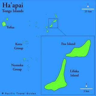
Pangai is the administrative capital village of the Haʻapai Group in Tonga.
Winslow Reef is a submerged coral reef of the southern Cook Islands, located 133 kilometres northwest of Rarotonga, at 20°38′S160°56′W. It is a shallow platform reef. No major expeditions to explore Winslow Reef have taken place.
Sagchudak Island is a small island in the Andreanof Islands group in the Aleutian Islands of southwestern Alaska. The roughly rectangular island is approximately 1.4 miles (2.3 km) long and 0.6 mi (1 km) wide and lies about 0.93 mi (1.50 km) off the southern coast of Atka Island. The island's current name is nearly identical to the native Aleut name for the island and it entered navigational charts by the early 1850s. In the 1900s and 1910s, the island was one of many Aleutian islands stocked with foxes by the United States government for hunting and fur trading purposes. Although the foxes on uninhabited Sagchudak were not directly hunted, some were occasionally trapped and moved to and from the island to help ensure genetic stability in the various separated colonies.
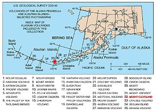
The Aleutian Arc is a large volcanic arc in the U.S. state of Alaska. It consists of a number of active and dormant volcanoes that have formed as a result of subduction along the Aleutian Trench. Although taking its name from the Aleutian Islands, this term is a geologic grouping rather than a geographic one, and the Aleutian Arc extends through the Alaska Peninsula following the Aleutian Range to the Aleutian Islands.
ʻOʻua is an island in Lulunga district, in the Haʻapai islands of Tonga. It is suggested that O'Ua is home to approximately 150 inhabitants. There are also different forms of spelling for the name of the island, ʻOʻua is just one of them.

Barrett Glacier is a glacier draining from the north slopes of the Prince Olav Mountains, about 15 nautical miles (30 km) long, flowing between the Longhorn Spurs and the Gabbro Hills to the Ross Ice Shelf. It was named by the Southern Party of the New Zealand Geological Survey Antarctic Expedition (1963–64) for Peter J. Barrett, a geologist with that party.
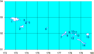
Lulunga is an island group and a district in Haʻapai administrative division of the Kingdom of Tonga. The archipelago consists of 17 islands, only 5 of which are inhabited. These are Haʻafeva, Matuku, Kotu, ʻOʻua and Tungua. The population of the whole island chain is nearly 500, most of whom live on Haʻafeva.
Gannet Island may refer to:
The Everett Water Pollution Control Facility is a wastewater treatment plant in Everett, Washington, United States. It serves the city of Everett and discharges treated water into the Snohomish River. The facility is located at the south end of Smith Island, adjacent to Interstate 5 and Spencer Island Regional Park, a noted birdwatching spot.
UFC Fight Night: Hermansson vs. Weidman is an upcoming mixed martial arts event produced by the Ultimate Fighting Championship originally planned to take place on May 2, 2020 at Chesapeake Energy Arena in Oklahoma City, Oklahoma, United States. Due to the 2019–20 coronavirus pandemic, UFC president Dana White announced on April 9 that starting with UFC 249, all future events were indefinitely postponed.