Related Research Articles

Mora Municipality is a municipality in Dalarna County in central Sweden. Its seat is located in the town of Mora.

Alingsås Municipality is a municipality in Västra Götaland County in western Sweden. Its seat is located in the city of Alingsås.

Karlsborg Municipality is a municipality in Västra Götaland County in western Sweden. Its seat is located in the town of Karlsborg.

Sorsele Municipality is a municipality in Västerbotten County in northern Sweden. Its seat is located in Sorsele.

The Usarp Mountains is a major Antarctic mountain range, lying westward of the Rennick Glacier and trending N-S for about 190 kilometres (118 mi). The feature is bounded to the north by Pryor Glacier and the Wilson Hills. Its important constituent parts include Welcome Mountain, Mount Van der Hoeven, Mount Weihaupt, Mount Stuart, Mount Lorius, Smith Bench, Mount Roberts, Pomerantz Tableland, Daniels Range, Emlen Peaks, Helliwell Hills and Morozumi Range.

Zalha is a commune located in Sălaj County, Romania. It is composed of seven villages: Ceaca (Almáscsáka), Ciureni (Csurenypuszta), Valea Ciurenilor (Csurenyvölgy), Valea Hranei (Tormapataka), Valea Lungă (Gorbómező), Vârteșca (Virtyeskatelep) and Zalha.

Craiva is a commune in Arad County, Romania. The commune Craiva is situated in the contact zone of the Susag's high plateau with Mărăușului Hills and Codru-Moma Mountains, along the Sartiș River, having an administrative territory of 11,490 hectares. It is composed of ten villages: Chișlaca (Kislaka), Ciuntești (Csontaháza), Coroi (Bélkaroly), Craiva, Mărăuș (Bélnagymaros), Rogoz de Beliu (Bélrogoz), Stoinești (Bélkismaros), Susag (Pusztaszuszág), Șiad (Sajád) and Tălmaci (Bántolmács).
Buești is a commune located in Ialomița County, Romania. It is composed of a single village, Buești.
Filipeni is a commune in Bacău County, Romania. It is composed of eight villages: Bălaia, Brad, Filipeni, Fruntești, Mărăști, Pădureni, Slobozia and Valea Boțului.
Stojadła is a village in the administrative district of Gmina Mińsk Mazowiecki, within Mińsk County, Masovian Voivodeship, in east-central Poland. It lies approximately 3 kilometres (2 mi) west of Mińsk Mazowiecki and 37 km (23 mi) east of Warsaw.

The 2008-09 Biathlon World Cup - World Cup 1 was the opening event of the season and has been held in Östersund, Sweden. From Wednesday December 3 until Sunday December 7, 2008.
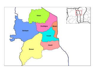
Kozah is a prefecture located in the Kara Region of Togo.
The 2009–10 Biathlon World Cup - World Cup 1 was the opening event of the season and has been held in Östersund, Sweden, from 2 December until 6 December 2009

Oued Fodda District is a district of Chlef Province, Algeria.
Lähtse is a village in Vinni Parish, Lääne-Viru County, in northeastern Estonia.
Kiisamaa is a village in Lääneranna Parish, Pärnu County in southwestern Estonia.
The 2010–11 Biathlon World Cup - World Cup 1 was the opening event of the season and was held in Östersund, Sweden, from 1 December until 5 December 2010.

The 2011–12 Biathlon World Cup – World Cup 1 is the opening event of the season and is held in Östersund, Sweden, from 30 November until 4 December 2011.
References
- ↑ "Län och huvudavrinningsområden i Sverige" (PDF) (in Swedish). Swedish Meteorological and Hydrological Institute . Retrieved 15 July 2010.
Coordinates: 63°11′N18°32′E / 63.183°N 18.533°E

A geographic coordinate system is a coordinate system that enables every location on Earth to be specified by a set of numbers, letters or symbols. The coordinates are often chosen such that one of the numbers represents a vertical position and two or three of the numbers represent a horizontal position; alternatively, a geographic position may be expressed in a combined three-dimensional Cartesian vector. A common choice of coordinates is latitude, longitude and elevation. To specify a location on a plane requires a map projection.
| This article related to a river in Sweden is a stub. You can help Wikipedia by expanding it. |