
USS Croatan (CVE-25) was a Bogue-class escort carrier launched on 1 August 1942 by the Seattle-Tacoma Shipbuilding Corporation of Seattle, Washington, under a Maritime Commission contract; sponsored by Mrs. J. S. Russell; and commissioned on 28 April 1943.
This is a list of the extreme points of the United Kingdom: the points that are farther north, south, east or west than any other location. Traditionally the extent of the island of Great Britain has stretched "from Land's End to John o' Groats".

St George's Channel is a sea channel connecting the Irish Sea to the north and the Celtic Sea to the southwest.

European route E22 is one of the longest European routes. It has a length of about 5,320 km (3,310 mi). Many of the E-roads have been extended into Asia since the year 2000; the E22 was extended on 24 June 2002.

Los Córdobas is a town and municipality located in the Córdoba Department, northern Colombia.

Garbh Eilean is one of the Shiant Islands at the south end of the Minch on the west coast of Scotland.

The Potawatomi Islands is the most common historic name given to the string of islands that delineate the transition from Green Bay to Lake Michigan, one of the Great Lakes. The archipelago is also termed the "Grand Traverse Islands".
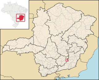
Cipotânea is a Brazilian municipality located in the state of Minas Gerais. The city belongs to the mesoregion of Zona da Mata and to the microregion of Viçosa. Its area is 153.435 km². As of 2020, the estimated population was 6,799.
Prey Touch is a khum (commune) of Moung Ruessei District in Battambang Province in north-western Cambodia.

Dawu Township (Chinese: 大武鄉; pinyin: Dàwǔ Xiāng; Wade–Giles: Ta4-wu3 Hsiang1) is a rural township in Taitung County, Taiwan.
Cella is a town in the Tenkodogo Department of Boulgou Province in south-eastern Burkina Faso. As of 2005, the town has a population of 1,731.
Zonsé is a town and seat of the Zonsé Department of Boulgou Province in south-eastern Burkina Faso. As of 2005, the town has a population of 787.
This is a list of the extreme points and extreme elevations in Scotland.

El Fahs is a town and commune located in the Zaghouan Governorate, 60 kilometers south-west of Tunis, Tunisia. Its population in 2014 was 25,100.
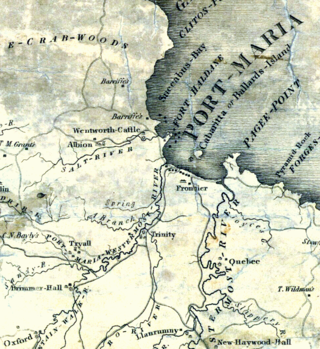
The Otram River, formerly known as the Port Maria River or the Port Maria Western River, is a river in Saint Mary Parish, Jamaica. It reaches the sea in the parish capital of Port Maria and contributes to flooding in that town.
Sabaa Aiyoun is a town in El Hajeb Province, Fès-Meknès, Morocco. According to the 2004 census it has a population of 21,513.

Sidi Ameur is a town and commune in M'Sila Province, Algeria. According to the 1998 census it has a population of 18,721.
Draga is a village in the municipality of Tutin, in the Sandzak-Region of southwestern Serbia. According to the 2002 census, the village had a population of 950 people.

The Cutch Agency was one of the agencies of British India. The appointed Political Agent looked after only one territory, that of the princely state of Cutch, which had a surface of 19,725 square kilometres (7,616 sq mi), not including the Rann of Kutch.

