Related Research Articles
Monongahela or Mon Valley may refer to:

Elizabeth is a borough in Allegheny County, Pennsylvania, United States, on the east bank of the Monongahela River, where Pennsylvania Route 51 crosses, 15 miles (24 km) upstream (south) of Pittsburgh and close to the county line. The population was 1,398 at the 2020 census. The borough of Elizabeth is entirely contained within the 15037 USPS ZIP code. The local school district is the Elizabeth Forward School District. The borough is home to neighborhoods Walker Heights and Town Hill. Elizabeth Borough is the birthplace of Town Hill Hockey established in 1978.
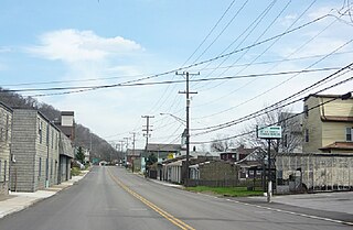
West Elizabeth is a borough in Allegheny County, Pennsylvania, United States. The population was 403 at the 2020 census.
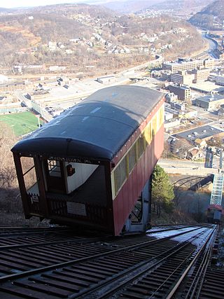
The Johnstown Inclined Plane is a 896.5-foot (273.3 m) funicular in Johnstown, Cambria County, Pennsylvania, U.S. The incline and its two stations connect the city of Johnstown, situated in a valley at the confluence of the Stonycreek and the Little Conemaugh rivers, to the borough of Westmont on Yoder Hill. The Johnstown Inclined Plane is billed as the "world's steepest vehicular inclined plane". It can carry automobiles and passengers, up or down a slope with a grade of 71.9%. The travel time between stations is 90 seconds.

The South Side Flats is a neighborhood in Pittsburgh, Pennsylvania's South Side area. It is located just south of the Monongahela River. The neighborhood has one of the City of Pittsburgh's largest concentrations of 19th-century homes, which has prompted outsiders to call the neighborhood the City's Georgetown. It includes many bars and restaurants as well as residences. The main throughway in the South Side Flats is East Carson Street. The street is home to a significant portion of Pittsburgh's nightlife.

Knoxville is a neighborhood in southern Pittsburgh, Pennsylvania, United States. It is part of zip code 15210, and has representation on Pittsburgh City Council by the council member for District 3.

Troy Hill is a neighborhood on Pittsburgh, Pennsylvania's North Side. It has a zip code of 15212, and has representation on Pittsburgh City Council by the council member for District 1.

The Monongahela Incline is a funicular on the South Side in Pittsburgh, Pennsylvania, United States, near the Smithfield Street Bridge. Designed and built by Prussian-born engineer John Endres in 1870, it is the oldest continuously operating funicular in the U.S.

A large metropolitan area that is surrounded by rivers and hills, Pittsburgh has an infrastructure system that has been built out over the years to include roads, tunnels, bridges, railroads, inclines, bike paths, and stairways; however, the hills and rivers still form many barriers to transportation within the city.

Cincinnati Street Railway (CSR) was the public transit operator in Cincinnati, Ohio, from 1859 to 1952. The company ceased streetcar operations and was renamed Cincinnati Transit Company.
West Liberty Borough was a borough in Allegheny County, Pennsylvania, United States from 1876 to 1909. West Liberty Borough was incorporated on March 7, 1876 from the western part of Lower St. Clair Township. The borough was a small village along the Pittsburgh and Washington Road near Mount Washington. West Liberty Borough was absorbed by the city of Pittsburgh in 1909. It is today the Brookline neighborhood, Bon Air neighborhood, and part of the Beechview neighborhood.
The Whitehall Branch was a rail line owned and operated by the Pennsylvania Railroad in the U.S. state of Pennsylvania. The line ran from Monongahela Branch near the 30th Street yard to a connection with the Pittsburgh and Lake Erie Railroad and the Allegheny and South Side Railway at the 21st Street Yard in the South Side of Pittsburgh. The line was abandoned by Conrail and has been removed.
The Keeling Coal Company (1861–1878) was a 19th-century coal mining company in Allegheny County, Pennsylvania. Its mines were located in the Pittsburgh Coalfield of western Pennsylvania.

The Castle Shannon Incline was a funicular railroad in Pittsburgh, Pennsylvania that was part of the Pittsburgh and Castle Shannon Railroad. It ran down the southern slope of Mount Washington, as part of the route to the suburb of Castle Shannon, 6 miles south of the incline's location. It replaced an earlier incline dating to 1825 that brought coal down from a mine in Mount Washington.
The Pittsburgh, Virginia and Charleston Railway was a predecessor of the Pennsylvania Railroad in the U.S. state of Pennsylvania. By 1905, when it was merged into the Pennsylvania, it owned a main line along the left (west) side of the Monongahela River, to Pittsburgh's South Side from West Brownsville. Branches connected to the South-West Pennsylvania Railway in Uniontown via Redstone Creek and to numerous coal mines.
The H.B. Hays and Brothers Coal Railroad was a narrow gauge railroad opened in 1878 to carry coal from the Hays family mines along Becks Run and Streets Run in Allegheny County, Pennsylvania. Both branches included an incline, and both are visible in the engravings below, one just south of Six Mile Ferry, the other in the hills south of the mouth of Becks Run. The mines, railroads, and inclines were designed by Pittsburgh engineer John H. McRoberts.
Samuel Diescher was a prominent Hungarian-American civil and mechanical engineer who had his career in the United States. After being educated at universities in Karlsruhe and Zurich in Europe, he immigrated to the United States in 1866 and settled in Cincinnati, Ohio. There he supervised construction of his first inclined plane. He later moved to Pittsburgh, Pennsylvania, where he worked with John Endres on the Monongahela Incline (1870), the first passenger incline in the city.

The Mount Oliver Incline was a funicular on the South Side of Pittsburgh, Pennsylvania. It was designed in 1871 by the Prussian-born engineer John Endres and his American daughter Caroline Endres, one of the first women engineers in the United States.
The Walton's Coal Incline was a nineteenth-century incline, used to transport coal from a mine mouth just west of West Elizabeth, Pennsylvania to a tipple on pool 2 of the Monongahela River. It crossed the entire width of the Borough of West Elizabeth, passing over the Pittsburgh, Virginia and Charleston Railway.
The St. Clair Incline, also known as the South Twenty-second Street Incline, was built in 1886–1888 and operated by St. Clair Incline Plane Company. It was a double track incline on the South Side Slopes of Pittsburgh from Josephine St. to Salisbury St. The lower station was near the intersection of S. 22nd Street and Josephine. The upper station was on Salisbury Street across from the former Fort Laughlin site eventually occupied by Arlington Playground. The incline was 2,060 ft (628 m) long, with a vertical rise of 361 ft (110 m). It was designed by engineer J. H. McRoberts. As it carried both freight and passengers over steep tracks laid on the ground, it could be considered to be a cable railway. Its path was not of constant slope but became progressively steeper toward the top, tracing a parabolic arc. It is uncertain exactly when the incline closed permanently, but it was reported as shut down in a 1932 Associated Press article about the "passing" of Pittsburgh's inclines. The structure was dismantled in 1934.
References
- ↑ "1876 Atlas of the Cities of Pittsburgh, Allegheny, and Adjoining Boroughs: Plate 26".
- ↑ Annual Report of the Secretary of Internal Affairs of the Commonwealth of Pennsylvania, 1876-77. Vol. V. Pennsylvania. Bureau of Industrial Statistics.; Pennsylvania. Dept. of Internal Affairs. Harrisburg, Pennsylvania: Lane S. Hart. 1878. p. 238.
{{cite book}}: CS1 maint: others (link)
| | This Pittsburgh-related article is a stub. You can help Wikipedia by expanding it. |