Related Research Articles

Oso is a census-designated place (CDP) in Snohomish County, Washington, United States. It is located to the west of Darrington, south of the North Fork of the Stillaguamish River and approximately 50 air miles (80 km) from Seattle. The population of Oso was 172 at the 2020 census. The area was the site of a large landslide in March 2014 that killed 43 people, the deadliest incident of its kind in U.S. history.

North Augusta is a city in Aiken and Edgefield counties in the U.S. state of South Carolina, on the north bank of the Savannah River. It lies directly across the river, and state border, from Augusta, Georgia. The population was 24,379 at the 2020 census, making it the 21st-most populous city in South Carolina. The city is included in the Central Savannah River Area (CSRA) and is part of the Augusta, Georgia, metropolitan area.

The Snoqualmie River is a 45-mile (72 km) long river in King County and Snohomish County in the U.S. state of Washington. The river's three main tributaries are the North, Middle, and South Forks, which drain the west side of the Cascade Mountains near the town of North Bend and join near the town of Snoqualmie just above the Snoqualmie Falls. After the falls the river flows north through rich farmland and the towns of Fall City, Carnation, and Duvall before meeting the Skykomish River to form the Snohomish River near Monroe. The Snohomish River empties into Puget Sound at Everett. Other tributaries of the Snoqualmie River include the Taylor River and the Pratt River, both of which enter the Middle Fork, the Tolt River, which joins at Carnation, and the Raging River at Fall City.

Mount Baker Wilderness is a 119,989-acre (48,558 ha) wilderness area within the Mount Baker-Snoqualmie National Forest in the western Cascade Range of northern Washington state. Its eastern border is shared with the boundary of the Stephen Mather Wilderness and North Cascades National Park for a distance of 40 miles. The wilderness extends from State Route 20 north to the Canada–US border. On the west, it is bounded by the foothills of the Puget Sound lowlands.
Blum Creek is a small glacial tributary of the Baker River in Washington state, in the United States. It is sourced from the Hagan Glacier and another unnamed glacier on the north face of Mount Blum, and flows approximately 1.5 miles (2.4 km) from there to its mouth at the Baker River. Hagan Glacier is located below Mount Blum and the creek is also fed by runoff from the Blum Lakes, a set of six lakes south of Bacon Peak. The creek joins the Baker River two drainages downstream of Sulphide Creek, another Baker River glacial tributary. Blum Creek forms the waterfall Blum Basin Falls as it tumbles down a 1,680-foot (510 m) glacial cliff. The creek's watershed is an overwintering location for the local Rocky mountain goats.

Boyne River is a stream in Northern Michigan, named for the River Boyne in Leinster, Ireland. Together with the north and south branches, the river system has approximately 22 miles (35 km) of mainstream and the water basin drains 40,320 acres (163.2 km2). Boyne River is Lake Charlevoix's second-largest tributary, after the Jordan River.
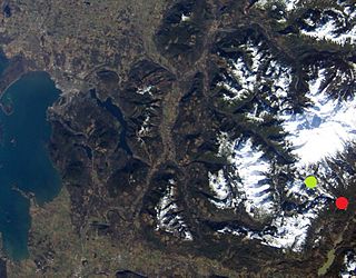
The Koma Kulshan Project is a 13.3 MW run-of-the-river hydroelectric generation facility on the slopes of Mount Baker, a stratovolcano in Washington state's North Cascades. The project commenced commercial operation in October 1990, and is owned by a Covanta Energy–Atlantic Power joint venture. It supplies Puget Sound Energy via a Power Supply Agreement (PSA) contract. Its single turbine is a Pelton wheel supplied by Sulzer Escher Wyss.
Robins is an unincorporated community in Guernsey County, in the U.S. state of Ohio.
Birdsview is an unincorporated community in Skagit County, in the U.S. state of Washington.
Boyd Creek is a stream in the U.S. state of Washington.
Grandy Creek is a stream in the U.S. state of Washington. The creek was named after John Grandy, a pioneer settler.
Jackman Creek is a stream in the U.S. state of Washington. It is a tributary of the Skagit River.
Pressentin Creek is a stream in the U.S. state of Washington.
Van Horn is an unincorporated community in Skagit County, in the U.S. state of Washington.
Brush Creek is a stream in Cole and Miller counties of the U.S. state of Missouri. It is a tributary of South Moreau Creek.
Gum Creek is a stream in Miller County in central Missouri. It is a tributary of the Osage River.
Shongelo is an unincorporated community in Smith County, in the U.S. state of Mississippi.
McKees Half Falls is an unincorporated community in Snyder County, in the U.S. state of Pennsylvania.

Bradmoor Island is an island in Suisun Bay. It is part of Solano County, California, and not managed by any reclamation district. Its coordinates are 38°11′26″N121°55′05″W, and the United States Geological Survey measured its elevation as 52 ft (16 m) in 1981.
References
- ↑ U.S. Geological Survey Geographic Names Information System: O'Toole Creek
- ↑ Meany, Edmond S. (1923). Origin of Washington geographic names. Seattle: University of Washington Press. p. 203.
48°30′47″N121°55′05″W / 48.51306°N 121.91806°W