
William B. Umstead State Park is a North Carolina state park in Wake County, North Carolina in the United States. It covers 5,599 acres (22.66 km2) nestled between the expanding cities of Raleigh, Cary, and Durham, North Carolina. It offers hiking, bridle, and bike trails, boat rentals, camping, picnic areas, and educational programs.

An off-road vehicle (ORV), sometimes referred to as an overland or adventure vehicle, is considered to be any type of vehicle which is capable of driving off paved or gravel surfaces, such as trails and forest roads that have rough and low traction surfaces.

Off-roading is the activity of driving or riding in a vehicle on unpaved surfaces such as sand, gravel, riverbeds, mud, snow, rocks, and other natural terrain. Types of off-roading range in intensity, from leisure drives with unmodified vehicles, to competitions with customised vehicles and professional drivers. Off-roading has been given criticism for the environmental damage caused by their vehicles. There have also been extensive debates over the role of government in regulating the sport, including a Supreme Court case brought against the Bureau of Land Management in the United States.

The Oregon Dunes National Recreation Area is located on the Oregon Coast, stretching approximately 40 miles (64 km) north of the Coos River in North Bend to the Siuslaw River in Florence, and adjoining Honeyman State Park on the west. It is part of Siuslaw National Forest and is administered by the United States Forest Service.

Guadalupe-Nipomo Dunes is the largest remaining dune system south of San Francisco and the second largest in the U.S. state of California. It encompasses an 18-mile (29 km) stretch of coastline on the Central Coast of California and extends from southern San Luis Obispo County to northern Santa Barbara County.

The San Luis Reservoir is an artificial lake on San Luis Creek in the eastern slopes of the Diablo Range of Merced County, California, approximately 12 mi (19 km) west of Los Banos on State Route 152, which crosses Pacheco Pass and runs along its north shore. It is the fifth largest reservoir in California. The reservoir stores water taken from the San Joaquin-Sacramento River Delta. Water is pumped uphill into the reservoir from the O'Neill Forebay which is fed by the California Aqueduct and is released back into the forebay to continue downstream along the aqueduct as needed for farm irrigation and other uses. Depending on water levels, the reservoir is approximately nine miles (14 km) long from north to south at its longest point, and five miles (8 km) wide. At the eastern end of the reservoir is the San Luis Dam, the fourth largest embankment dam in the United States, which allows for a total capacity of 2,041,000 acre-feet (2,518,000 dam3). Pacheco State Park lies along its western shores.

El Mirage Lake is a dry lake bed in the northwestern Victor Valley of the central Mojave Desert, within San Bernardino County, California.

The Algodones Dunes is a large sand dune field, or erg, located in the southeastern portion of the U.S. state of California, near the border with Arizona and the Mexican state of Baja California. The field is approximately 45 miles (72 km) long by 6 miles (9.7 km) wide and extends along a northwest-southeast line that correlates to the prevailing northerly and westerly wind directions. The name "Algodones Dunes" refers to the entire geographic feature, while the administrative designation for that portion managed by the Bureau of Land Management is the Imperial Sand Dunes Recreation Area. In 1966, Imperial Sand Hills was designated as a National Natural Landmark by the National Park Service. The Algodones Dunes are split into many different sections. These sections include Glamis, Gordon's Well, Buttercup, Midway, and Patton's Valley. Although the Arabic-derived Spanish word algodones translates to "cotton plants", the origin of the toponym is unknown.

Johnson Valley is a small unincorporated community in San Bernardino County in Southern California between Victor Valley and Morongo Basin areas of the High Desert region of California. It is north of Highway 247 in the Mojave Desert, and north by northwest of Yucca Valley. It is bordered by the San Bernardino Mountains to the south, Lucerne Valley to the west, and Landers to the east.

Lincoln National Forest is a unit of the U.S. Forest Service located in southern New Mexico. The Lincoln National Forest covers an extensive 1.1 million acres in southeastern New Mexico. Established by Presidential Proclamation in 1902 as the Lincoln Forest Reserve, the 1,103,897 acres (4,467.31 km2) forest begins near the Texas border and contains lands in parts of Chaves, Eddy, Lincoln, and Otero counties. The Lincoln National Forest is home to three major mountain ranges: Sacramento, Guadalupe and Capitan. The three Ranger Districts within the forest contain all or part of a total of four mountain ranges, and include a variety of different environmental areas, from desert to heavily forested mountains and sub-alpine grasslands. Clean air, water, and soil are necessary elements that the National Forests contribute to the environment. Established to balance conservation, resource management, and recreation, the lands of the Lincoln National Forest include important local timber resources, protected wilderness areas, and popular recreation and winter sports areas. The forest headquarters is located in Alamogordo, N.M. with local offices in Carlsbad, Cloudcroft, and Ruidoso.
Carnegie State Vehicular Recreation Area is a state park unit of California, U.S., providing off-roading opportunities in the Diablo Range. Located in southern Alameda and San Joaquin counties, it is one of eight state vehicular recreation areas (SVRAs) administered by the California Department of Parks and Recreation. With a diversity of terrain ranging from rolling hills to steep canyons, Carnegie has become a popular destination for off-road enthusiasts of all skill levels.

The Dinkey Lakes Wilderness is a federally designated wilderness area located 45 miles (72 km) northeast of Fresno, in the state of California, United States. It comprises 30,000 acres (12,141 ha) within the Sierra National Forest and was added to the National Wilderness Preservation System by the California Wilderness Act of 1984. Elevations range from 8,200 feet (2,500 m) to 10,619 feet (3,237 m). Recreational activities in the wilderness include day hiking, backpacking, horseback riding, fishing, rock climbing and cross-country skiing.

The Christmas Valley Sand Dunes are a natural sand dune complex covering 11,000 acres (45 km2) of public lands east of Christmas Valley in Lake County, Oregon, United States, about 100 miles (160 km) southeast of Bend. The area is accessible via the Christmas Valley National Back Country Byway. The dunes are up to 60 feet (18 m) high. It is the largest inland shifting sand dune system in the Pacific Northwest. The dunes are composed mostly of ash and pumice from the eruption of Mount Mazama that formed Crater Lake 7,000 years ago. Approximately 8,900 acres (36 km2) of dunes are open to vehicles.
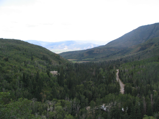
Wasatch Mountain State Park is a state park of Utah, United States, located in the northern part of the state within the Wasatch Back area on the north and west edges of the Heber Valley in Wasatch County near the city of Midway.
The California Desert Protection Act of 2010 was legislation proposed by U.S. Senator Dianne Feinstein. The stated aim of the legislation was "to provide for conservation, enhanced recreation opportunities, and development of renewable energy in the California Desert Conservation Area."
The Foot Hills State Forest is a state forest located in Cass and Hubbard counties, Minnesota. The forest is a popular recreation spot due to its proximity to the greater Minneapolis – Saint Paul metropolitan area.
Jordan River Off-Highway Vehicle State Recreation Area is a Utah State Park located in Salt Lake City, Utah, USA. The park is dedicated to recreation with off highway vehicles. It consists of four separate tracks, with tabletops and banked turns, and is open from approximately early April to approximately mid-October. Off-highway motorcycle (OHM) riders have access to two motocross tracks. The novice and grand-prix tracks are open to both OHMs and all-terrain vehicles.
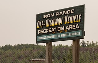
Iron Range Off-Highway Vehicle State Recreation Area is a Minnesota state park located east of Lake Ore-be-gone in Gilbert, Minnesota. The recreation area consists of 36 miles (58 km) of trails on a 1,864-acre (754 ha) unit, all of which was local iron ore mining land until 1981. A 3,500-acre (1,400 ha) expansion of the recreation area is also being planned, with land acquisition underway.
The Arizona Peace Trail is a 675 mi (1,086 km) off-highway vehicle trail loop system in Mohave, La Paz, and Yuma counties in western Arizona. It is supported by the Arizona Peace Trail Committee, which was formed in 2014, and as of early 2016, fourteen OHV clubs.

Cow Mountain is a ridge in the Mayacamas Mountains in Lake County, California and Mendocino County, California. It is home to two large recreation areas. One is closed to off-road vehicles and the other is not. Erosion from the mountain, caused in part by human land use, contributes sediment and nutrients to Clear Lake.