
Bosque County is a county located on the Edwards Plateau in the U.S. state of Texas. As of the 2010 census, the population was 18,212. Its county seat is Meridian, while Clifton is the largest city and the cultural/financial center of the county. The county is named for the Bosque River, which runs through the center of the county north to south. The Brazos River makes up the eastern border along with the Lake Whitney reservoir it feeds.

Water Valley is a home rule-class city in Graves County, Kentucky, United States. The population was 279 as of the 2010 census.
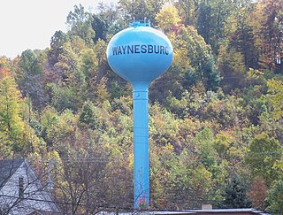
Waynesburg is a village in Stark County, Ohio, United States. The population was 923 at the 2010 census, a decrease from 1,003 in 2000. It is part of the Canton-Massillon, OH Metropolitan Statistical Area.

Ancient Oaks is a census-designated place (CDP) in Lower Macungie Township, Lehigh County, Pennsylvania, in the United States. Ancient Oaks is a suburb of Allentown, in the Lehigh Valley region of the state. It is named after the housing subdivision named Ancient Oaks, located off PA Route 100 just north of Macungie.
Oak Valley is a town in Navarro County, Texas, United States. The population was 368 at the 2010 census.

The Greenbelt is a 203.5-square-kilometre (78.6 sq mi) protected green belt traversing Ottawa, Ontario, Canada. It includes green space, forests, farms, and wetlands from Shirleys Bay in the west and to Green's Creek in the east. The National Capital Commission (NCC) owns and manages 149.5 square kilometres (57.7 sq mi), and the rest is held by other federal government departments and private interests. Real estate development within the Greenbelt is strictly controlled.

The Afon Rheidol is a river in Ceredigion, Wales, 19 miles (31 km) in length. The source is Plynlimon, the largest watershed in Wales with a catchment area covering 73 square miles (189 km2). Receiving an average annual rainfall of 40 inches (1015 mm) Plynlimon is the source of both the Wye and the Severn.
North Central Arizona is a geographical region of Arizona. It is in the Transition Zone between the Basin and Range Province and the Colorado Plateau, and has some of the most rugged and scenic landscapes in Arizona.

Osgoode Township is a former township that is now a part of the city of Ottawa, Ontario, Canada. The township along the Rideau River was established in 1798 and incorporated in 1850. It was an independent township in Carleton County until its amalgamation with the city in 2001. It remains a largely rural area with only some 23,285 inhabitants as of the 2016 census. On Ottawa city council it is represented by George Darouze.
Sequoyah Heights is a smaller part of the Oak Knoll neighborhood that runs alongside the southeastern part of the Oakland hills. The neighborhood borders San Leandro.

Salem Community College (SCC) is a public community college in Salem County, New Jersey. Salem Community College's main 11-acre (45,000 m2) campus is in Carneys Point Township. SCC is authorized to grant associate degrees—Associate in Arts, Associate in Fine Arts, Associate in Science and Associate in Applied Science—and certificates. SCC also offers the only degree program in the US for scientific glassblowing.

The Perkiomen Trail is a 19-mile-long (31 km) multi-use rail trail along the Perkiomen Creek in Pennsylvania.

The North Coast of California is the region in Northern California that lies on the Pacific coast between San Francisco Bay and the Oregon border. The area is named after the dense redwood forests throughout the region. It commonly includes Mendocino, Humboldt, and Del Norte counties and sometimes includes two counties from the San Francisco Bay area, Marin and Sonoma.

Bald Mountain is a prominent peak in Northeastern Pennsylvania which stands above the Wilkes-Barre and Scranton area. On the summit is an outcrop of Catskill conglomerate known as the "Pinnacle Rock". From the summit you may view the northernmost extension of the geologic province known as the Glaciated Low Plateaus section. The mountain itself is in the Ridge and Valley Appalachians. It is a great place for photography.

The André-Michaux Ecological Reserve, or Réserve écologique André-Michaux, is an ecological reserve in Quebec, Canada. It protects a variety of vegetation types typically of the Canadian Shield.

Chichester is a region in Delaware County, Pennsylvania, United States, that includes the townships of Upper Chichester and Lower Chichester, and the boroughs of Marcus Hook and Trainer. Other communities included in the region are Linwood, Boothwyn, Ogden, and Twin Oaks.

The Black Hills of Greenlee County are a 20 mi (32 km) long mountain range of the extreme northeast Sonoran Desert bordering the south of the White Mountains of eastern Arizona's transition zone.

Fremont Weir Wildlife Area is 1,461 acres at the north end of the Yolo Bypass floodway along the Sacramento River in Sutter County and Yolo County. It is 6 miles north-east of the city of Woodland and 15 miles north of Yolo Bypass Wildlife Area and the nearby Sacramento Bypass Wildlife Area. Whenever water in the river exceeds the height of the weir the excess flow runs over the weir and down the Yolo Bypass floodway, thereby reducing the risks of flooding in the city of Sacramento and nearby urban areas along the river.
Claudell is an unincorporated community in Valley Township, Smith County, Kansas, United States.
Burr Oak is an extinct town in Lincoln County, in the U.S. state of Missouri.
