Stafford is a town in Genesee County, New York, United States. The population was 2,459 at the 2010 census. The town was named after a town of the same name in England.

Scottsville is a village in southwestern Monroe County, New York, United States, and is in the northeastern part of the Town of Wheatland. The population was 2,001 at the 2010 census. The village is named after an early settler, Isaac Scott. Most Scottsvillians work in and around the city of Rochester, New York—the village of Scottsville is located about a ten-minute drive from the outer limits of the city.
State Route 522 (SR 522) is a state highway in the U.S. state of Washington that serves the Seattle metropolitan area. Approximately 25 miles (40 km) long, it connects the city of Seattle to the northeastern suburbs of Kenmore, Bothell, Woodinville, and Monroe. Its western half is primarily an arterial street, named Lake City Way and Bothell Way, that follows the northern shore of Lake Washington; the eastern half is a grade-separated freeway that runs between Woodinville and Monroe. SR 522 connects several of the metropolitan area's major highways, including Interstate 5 (I-5), I-405, SR 9, and U.S. Route 2 (US 2).

The River Raisin is a river in southeastern Michigan, United States that flows through glacial sediments into Lake Erie. The area today is an agricultural and industrial center of Michigan. The river flows for almost 139 miles (224 km), draining an area of 1,072 square miles (2,780 km2) in the Michigan counties of Lenawee, Monroe, Washtenaw, Jackson, Hillsdale, a portion of Fulton County, Ohio, and Monroe County, where its mouth at Lake Erie is located. French settlers named it as La Rivière aux Raisins because of the wild grapes growing along its banks, since the French word for grape is raisin. The French term for "raisin" is raisin sec.
M-125 is a 19 1⁄2-mile-long (31.4 km) state trunkline highway in the US state of Michigan. The highway is entirely within Monroe County with the southern terminus on the Ohio state border near Toledo and a northern terminus at US Highway 24 (US 24) in Frenchtown Township, 5 miles (8.0 km) north of Monroe. M-125 runs through rural farmlands and connects a couple of smaller towns with Monroe. It has an unsigned connector highway that links the main highway with Interstate 75 (I-75).

New York State Route 36 (NY 36) is a north–south state highway in the western part of New York in the United States. The highway extends for 95 miles (153 km) from the Pennsylvania state line at Troupsburg, Steuben County northward to Ogden, Monroe County, where it ends at an intersection with NY 31. Along the way, NY 36 passes through the villages of Canisteo, Dansville, Mount Morris, Caledonia, and Churchville and the city of Hornell. The section of the route between Dansville and Mount Morris closely parallels Interstate 390 (I-390); however, from Dansville south and Mount Morris north, NY 36 serves as a regionally important highway, connecting to I-86, U.S. Route 20A (US 20A), US 20, and I-490 as it heads north. At its south end, NY 36 connects to Pennsylvania Route 249 (PA 249).
New York State Route 19 (NY 19) is a north–south state highway in Western New York in the United States. It is the longest state highway in that region, and the only other one besides NY 14 to completely transect the state from the Pennsylvania state line to the shore of Lake Ontario. It continues south into Pennsylvania as Pennsylvania Route 449 (PA 449) and ends at an intersection with the Lake Ontario State Parkway just south of the lakeshore in Hamlin. NY 19 does not serve any major cities or metropolitan areas and remains a two-lane rural road for almost its entire length. However, it follows the Genesee River for much of its lower length, and offers easy access to the gorges of Letchworth State Park midway along its route.

U.S. Route 20A (US 20A) is an east–west alternate route of US 20 that extends for 83.59 miles (134.53 km) across the western portion of New York in the United States. It leaves US 20 in Hamburg, a suburb of Buffalo, and rejoins it in East Bloomfield about five miles (8 km) west of Canandaigua, the county seat of Ontario County. The western terminus is situated just northeast of the intersection of US 20 and US 62 and west of New Era Field. At its east end, US 20A also meets New York State Route 5 (NY 5) and NY 64. Most of the route is known as Big Tree Road; outside New Era Field, the highway is known as the Timothy J. Russert Highway in memory of Buffalo native Tim Russert.
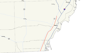
New York State Route 253 (NY 253) is a 10.83-mile (17.43 km) long east–west state highway in Monroe County, New York, in the United States. The western terminus of the route is at NY 383 in the village of Scottsville. Its eastern terminus is at NY 65 in the town of Pittsford. NY 253 meets Interstate 390 (I-390) and connects to the New York State Thruway (I-90) in the town of Henrietta. The majority of NY 253 passes through either rural or residential areas; however, the midsection of NY 253 is located in a heavily commercial portion of Henrietta.
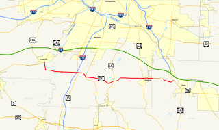
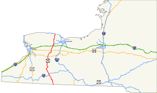
New York State Route 251 (NY 251) is an east–west state highway in western New York in the United States. It extends for 17.79 miles (28.63 km) from NY 383 in Scottsville, Monroe County, to NY 96 in the town of Victor, Ontario County. NY 251 connects to Interstate 390 (I-390) in Rush and serves the village of Honeoye Falls and the hamlet of Mendon within the town of the same name. The route, a two-lane, rural highway for much of its length, also intersects NY 15 and NY 64, two north–south highways leading to the Southern Tier and the Finger Lakes, respectively. Two sections of the route—from south of Scottsville to Rush and from Mendon to western Victor—follow linear east–west alignments. All but 3 miles (5 km) of the route are located in Monroe County.

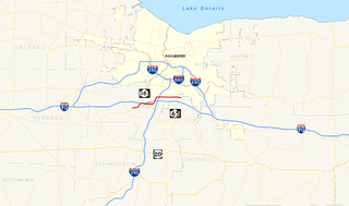
New York State Route 383 (NY 383) is an 18.70-mile (30.09 km) north–south state highway in Monroe County, New York, in the United States. The southern terminus of the route is at an intersection with NY 36 in the hamlet of Mumford within the town of Wheatland. Its northern terminus is at a junction with NY 31 in the city of Rochester. The route follows the Genesee River and its tributaries for its entire length and passes through the village of Scottsville.
U.S. Highway 1 (US 1) in Florida runs 545 miles (877 km) along the state's east coast– from Key West to its crossing of the St. Marys River into Georgia north of Boulogne –and south of Folkston. US 1 was designated through Florida when the United States Numbered Highway System was established in 1926. The road is maintained by the Florida Department of Transportation (FDOT).

U.S. Route 78 (US 78) is a 233.3-mile-long (375.5 km) U.S. Highway in the U.S. state of Georgia. It travels west to east in the north-central part of the state, starting at the Alabama state line, west of Tallapoosa, where the roadway continues concurrent with the unsigned highway Alabama State Route 4. This is also the western terminus of Georgia State Route 8 (SR 8), which is concurrent with US 78 to the east. The highway serves the Atlanta, Athens, and Augusta metropolitan areas on its path from the Alabama state line to the South Carolina state line, at the Savannah River, on the northeastern edge of Augusta, where it continues concurrent with US 1/US 25/US 278/SC 121. This is also the eastern terminus of SR 10 and the northern terminus of SR 121, as well as the southern terminus of SC 121. US 78 travels through portions of Haralson, Carroll, Douglas, Cobb, Fulton, DeKalb, Gwinnett, Walton, Oconee, Clarke, Oglethorpe, Wilkes, McDuffie, Columbia, and Richmond counties.

Garbutt, New York is a hamlet located between the village of Scottsville and the hamlet of Mumford. It sits at the intersection of Scottsville-Mumford Road and Union Street in the Town of Wheatland in Monroe County. Garbutt grew rapidly through the mid-nineteenth century, but starting in the late nineteenth and early twentieth centuries the collapse of the local economy caused the population to severely decline.
The Scottsville Free Library, located at 28 Main Street in the village of Scottsville, New York, with a small branch at 883 George Street in Mumford, serves the people of the towns of Wheatland and Chili, as well as adjacent areas in Monroe County.
The Scottsville and LeRoy Railroad was a horse-drawn short-line railroad running from Scottsville to Caledonia, in New York State, in the United States of America. It was chartered in 1836 and ran until 1840, when changes in the canal system reduced demand. The eight-mile long line used wooden rails, which were a continual source of derailments.

The Jefferson Avenue–Huron River and Harbin Drive–Silver Creek Canal Bridges are two separate bridges, sharing a continuous railing, that were jointly listed on the National Register of Historic Places on February 10, 2000.