
The Pčinja District is one of nine administrative districts of Southern and Eastern Serbia. It covers the southern part of Serbia, bordering the disputed territory of Kosovo, Bulgaria and North Macedonia. Its administrative center is the city of Vranje.
Crni Vrh means "black peak" in Bosnian-Croatian-Serbian. It can refer to the following toponyms:

The Morava Valley, is a general term which in its widest sense marks valleys of any of three Morava rivers in Serbia: the West Morava, the South Morava and the Great Morava. In the narrow sense, the term is applied only to the Great Morava Valley. The Serbian term follows the general manner of coining river valley names in Serbian using the prefix po- and suffix -je, meaning literally "(land) along the Morava". Morava valley lies in the central Balkans, at the crossroads which lead eastwards, towards the Black sea and Asia Minor, and further south, down the Vardar river into the Aegean sea.

The City municipality of Vranjska Banja is a town and one of two city municipalities which constitute the City of Vranje. It is also one of the spa resorts in Serbia. Located 12 km (7 mi) northeast from the city of Vranje, it is surrounded by forests and rolling hills which offer nice scenery, and a good restaurant by the old clinic is situated at the end of the town.

FK Dinamo Vranje is a professional football club from Vranje, Serbia. They currently compete in the Serbian SuperLiga, the top tier of the national league system.

Stojan Vranješ is a Bosnian professional footballer who plays for FK Borac Banja Luka in the First League of the Republika Srpska.

White Bridge or Bridge of love, is a bridge in Vranje, over the Vranje river, in southeastern Serbia. It is located in the old quarters of the city, in the Devet Jugovića Street. It was constructed with white stone and dates from 1844, during the Ottoman administration, and is one of the main symbols of Vranje. The bridge is also featured on the city coat of arms.

Grot is a mountain in southern Serbia, near the city of Vranje. Its highest peak has an elevation of 1,327 meters above sea level.
Pljačkovica is a mountain in southern Serbia, overlooking the city of Vranje. Its highest peak has an elevation of 1,231 meters above sea level.
Zladovska planina is a mountain in southern Serbia, near the town of Trgovište. Its highest peak Zelenčev vrh has an elevation of 1,574 meters above sea level.
The Serbian Women's Cup is the national women's football cup competition in Serbia and was first held in 2007.
The City municipality of Vranje is one of two city municipalities which constitute the City of Vranje. According to the 2011 census results, the municipality has a population of 73,944 inhabitants, while the urban area has 55,138 inhabitants.

Markovo Kale is a fortress located 3.5 kilometres (2.2 mi) northwest of Vranje, Serbia. It's situated on a steep rocky crest between the mountains Krstilovica and Pljačkavica. The fortification is surrounded by two rivers on the bottom, Devotinska and Mala Reka.
Spiro Crne was a rebel leader active in Ottoman Macedonia. Born in a village near Prilep, he killed an Ottoman tyrant and fled to Serbia, in the north. In Vranje, he established a rebel band trained and armed by the Serbian military government that was sent into Macedonia.
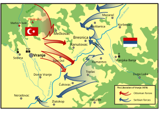
The Battle of Vranje, or the Liberation of Vranje, represented one of the final stages of the second phase of the Serbian–Ottoman War (1876–78). At the beginning of the war, the Serbian army began the offensive in what is today South Serbia. After the Battle of Grdelica, the Serbian army managed to break into the Masurica Valley leaving the road to Vranje open and unguarded. At the same time, many rebellions broke out in the Serbian-Ottoman border areas, including in the Vranje region, against Ottoman authority. To help the rebels, the Serbian command decided to send Lieutenant Stepa Stepanović to form a special rebel battalion.


