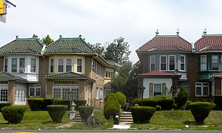
Kingsessing is a neighborhood in the Southwest section of Philadelphia, Pennsylvania, United States, located next to the neighborhoods of Cedar Park, Southwest Schuylkill, and Mount Moriah, as well as the borough of Yeadon in Delaware County. It is roughly bounded by Cobbs Creek and 60th Street to the southwest, Woodland Avenue to the southeast, 53rd Street to the northeast, and Baltimore Avenue to the northwest.
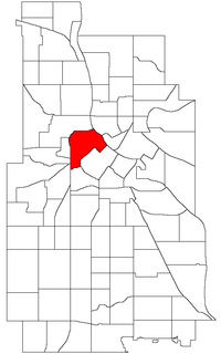
The North Loop is a neighborhood of the Central community of Minneapolis, Minnesota. The neighborhood is commonly known as the Warehouse District from the city's shipping hub years. It includes the Minneapolis Warehouse Historic District which is listed on the National Register of Historic Places. The North Loop is located just northwest of the central business district between downtown Minneapolis and the Mississippi River. Streets in the North Loop are oriented to be parallel to the river, which means that they run at a 45-degree angle relative to the grid of the rest of the city.
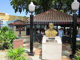
Little Havana is a neighborhood of Miami, Florida, United States. Home to many Cuban exiles, as well as many immigrants from Central and South America, Little Havana is named after Havana, the capital and largest city in Cuba.
Cobbs Creek is a neighborhood located in the West Philadelphia section of Philadelphia, Pennsylvania, United States. Cobbs Creek is generally bounded by Market Street to the north, Baltimore Avenue to the south, 52nd Street to the east, and Cobbs Creek Parkway to the west. It is often locally referred to as "The Southside", in reference to its location to the south of Market Street and above the Baltimore Avenue border of Southwest Philadelphia, as well as a neighborhood distinction used by local street gangs in the area during the 1960s and 1970s.

The Munger Place Historic District is a neighborhood and historic district in Old East Dallas, Texas (USA), generally lying between North Fitzhugh Avenue on the southwest, Gaston Avenue on the northwest, Henderson Avenue on the northeast, and Columbia Avenue on the southeast. Detailed boundaries are defined in the Munger Place Ordinance. It is a Dallas Landmark District and listed on the National Register of Historic Places.

Old Town Chinatown is the official Chinatown of the Northwest section of Portland, Oregon. The Willamette River forms its eastern boundary, separating it from the Lloyd District and the Kerns and Buckman neighborhoods. It includes the Portland Skidmore/Old Town Historic District and the Portland New Chinatown/Japantown Historic District, which are listed on the National Register of Historic Places.

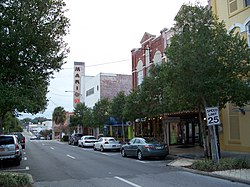
The Ocala Historic District is a U.S. Historic District located in Ocala, Florida. It encompasses 172 acres (0.70 km2), and is bounded by Broadway, Southeast 8th Street, Silver Springs Place, Southeast 3rd, 13th, and Watula Avenues. It contains 220 historic buildings.

The Tuscawilla Park Historic District is a historic district in Ocala, Florida. It is bounded by Northeast 4th Street, Sanchez Avenue, 2nd Street, Tuscawilla Avenue, and Watula Street. It encompasses approximately 20 acres, and contains 37 historic buildings. On March 30, 1988, it was added to the National Register of Historic Places.
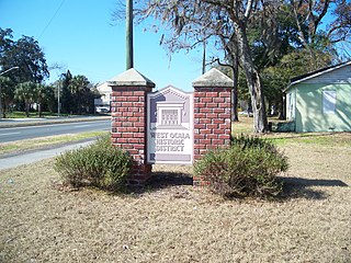
The West Ocala Historic District is a historic district in Ocala, Florida. It is roughly bounded by Northwest 4th Street, West Silver Springs Boulevard, and Northwest 12th Avenue, encompasses approximately 350 acres (1.4 km2), and contains 104 historic buildings. On June 27, 2002, it was added to the U.S. National Register of Historic Places.

The Waldo Historic District is a U.S. historic district in Waldo, Florida. It is bounded by Northwest 1st Avenue, Main Street, Southwest 5th Boulevard, and Southwest 4th Street, encompasses approximately 560 acres (230 ha), and contains 60 historic buildings. On February 2, 2001, it was added to the U.S. National Register of Historic Places.
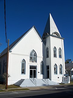
The Mount Zion A.M.E. Church is a historic church in Ocala, Florida, United States. It is located at 623 South Magnolia Avenue. The only surviving brick 19th-century religious structure in Ocala, the present Gothic Revival church stands behind the site of the original white frame building. Construction of the first brick church owned by a black congregation began in 1891 under the supervision of black architect and builder Levi Alexander, Sr.

The boundary markers of the original District of Columbia are the 40 milestones that marked the four lines forming the boundaries between the states of Maryland and Virginia and the square of 100 square miles (259 km²) of federal territory that became the District of Columbia in 1801. Working under the supervision of three commissioners that President George Washington had appointed in 1790 in accordance with the federal Residence Act, a surveying team that Major Andrew Ellicott led placed these markers in 1791 and 1792. Among Ellicott's assistants were his brothers Joseph and Benjamin Ellicott, Isaac Roberdeau, George Fenwick, Isaac Briggs and an African American astronomer, Benjamin Banneker.

Field Club is a neighborhood located in the Midtown region of Omaha, Nebraska. Roughly bounded by Pacific Street, 32nd Avenue, Center St., and 36th Street, the neighborhood was placed on the National Register of Historic Places as a historic district on November 15, 2000. Field Club is the location of dozens of historically significant homes in the Omaha area, including the Gerald R. Ford Birthsite and Gardens.

The Duke Ellington House is a historic residence at 935 St. Nicholas Avenue, in Manhattan, New York City. Apartment 4A in this apartment house was the home of Duke Ellington (1899-1974), the noted African American composer and jazz pianist, from 1939 through 1961. It was listed on the National Register of Historic Places as a National Historic Landmark in 1976.

The Campground Historic District, also known as The Campground is a historic district in the city of Mobile, Alabama, United States. Named for the Old Camp Ground, a military encampment that occupied the property during the American Civil War, this historically African-American neighborhood was placed on the National Register of Historic Places on July 7, 2005. It is roughly bounded by Martin Luther King Jr. Avenue, Rylands Street, St. Stephens Road, and Ann Street. The district covers 370 acres (1.5 km2) and contains 166 contributing buildings. The houses range from shotgun houses to bungalows and date from the late 19th century to the middle 20th century.
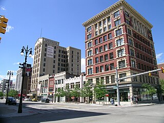
The Broadway Avenue Historic District is a historic district located on a single city block along Broadway Avenue between Gratiot and East Grand River in downtown Detroit, Michigan. It was listed on the National Register of Historic Places in 2004. The Broadway Avenue Historic District joins the Randolph Street Commercial Buildings Historic District, a rare surviving commercial area which dates from the 1840s.

The Fort Madison Downtown Commercial Historic District has a collection of late-19th century store fronts centered on Ave. G, from 6th to 9th Street, and Ave. H from 7th to 9th, in Fort Madison, Iowa. It was listed on the National Register of Historic Places in 2007.

Wakefield Park Historic District is a residential historic district encompassing a portion of a late-19th/early-20th century planned development in western Wakefield, Massachusetts. The district encompasses sixteen properties on 8 acres (3.2 ha) of land out of the approximately 100 acres (40 ha) that comprised the original development. Most of the properties in the district are on Park Avenue, with a few located on immediately adjacent streets.

The Central Court Historic District is a historic district and neighborhood of the city of Indianapolis in northern Center Township, Marion County, Indiana, United States. Built around Central Court near the intersection of Thirty-sixth Street and Central Avenue, the neighborhood consists of seventy-five buildings over an area of 7.6 acres (3.1 ha).
The Sherman Avenue Historic District is a historic district in central Madison, Wisconsin, United States, that is listed on the National Register of Historic Places (NRHP).