Related Research Articles

Sussex is an area within South East England that was historically a kingdom and, later, a county. It includes the ceremonial counties of East Sussex and West Sussex.

Plumstead is an area in southeast London, within the Royal Borough of Greenwich, England. It is located east of Woolwich.
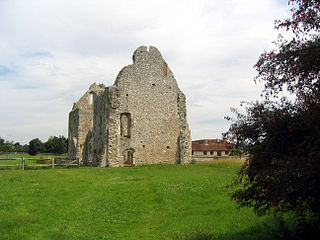
Boxgrove Priory is a ruined priory in the village of Boxgrove in Sussex, England. It was founded in the 12th century.

Bramley is a village and civil parish about three miles (5 km) south of Guildford in the Borough of Waverley in Surrey, south east England. Most of the parish lies in the Surrey Hills Area of Outstanding Natural Beauty.

Thomas Sutton was an English civil servant and businessman, born in Knaith, Lincolnshire. He is remembered as the founder of the London Charterhouse and of Charterhouse School.

Withyham is a village and large civil parish in the Wealden district of East Sussex, England. The village is situated 7 miles south west of Royal Tunbridge Wells and 3.5 miles (5.6 km) from Crowborough; the parish covers approximately 7,500 acres (30 km2).
Olveston is a small village and larger parish in South Gloucestershire, England. The parish comprises the villages of Olveston and Tockington, and the hamlets of Old Down, Ingst and Awkley. The civil parish population at the 2011 census was 2,033. Alveston became a separate church parish in 1846. The district has been inhabited since the Stone Age, and the salt marshes that made up almost half of the parish, were progressively drained in Roman and Saxon times. A sea wall was constructed at the same time to prevent flooding from the nearby estuary of the River Severn.

Bermondsey Abbey was an English Benedictine monastery. Although generally regarded as having been founded in the 11th century, it had a precursor mentioned in the early 8th century. It was centred on what is now Bermondsey Square, the site of Bermondsey Market, Bermondsey, in the London Borough of Southwark, southeast London, England.

Whitstone is a village and civil parish in east Cornwall, England, United Kingdom. It is roughly halfway between the towns of Bude and Launceston. The population at the 2011 census was 590.

Burstow is a village and civil parish in the Tandridge district of Surrey, England. Its largest settlement is Smallfield. Smallfield is 2.5 miles (4.0 km) ENE of Gatwick Airport and the M23 motorway, 7.5 miles (12.1 km) southwest of Oxted and 1.8 miles (2.9 km) east of Horley. Crawley is a nearby large commercial town, 3.7 miles (6.0 km) southwest of Burstow and 5 miles (8.0 km) southwest of Smallfield. Towards the outside of the London commuter belt, some residents commute to the capital by road or rail from here as London is 24.5 miles (39.4 km) to the north or Horley railway station is accessible.

Fifield Bavant is a small village in the civil parish of Ebbesborne Wake, in Wiltshire, England, about 6 miles (10 km) southwest of Wilton, midway between Ebbesbourne Wake and Broad Chalke on the north bank of the River Ebble. Fifield Bavant was formerly a separate civil parish. The small Church of England parish church, begun in the 13th century, is dedicated to Saint Martin and is a Grade II* listed building. The population is now about 20. In 1931 the parish had a population of 43.

The Manor Sports Ground, is a cricket venue in Worthing, West Sussex, England. It is home to Worthing Cricket Club.

King's Mead Priory was a Benedictine Priory situated west of Derby, in the area currently known as Nun's Street, or Nun's Green. It was the only Benedictine Nunnery in Derbyshire.
Loders Priory was a priory in Loders, Dorset, England.

Preston Manor is the former manor house of the ancient Sussex village of Preston, now part of the coastal city of Brighton and Hove, England. The present building dates mostly from 1738, when Lord of the manor Thomas Western rebuilt the original 13th-century structure, and 1905 when Charles Stanley Peach's renovation and enlargement gave the house its current appearance. The manor house passed through several owners, including the Stanfords—reputedly the richest family in Sussex—after several centuries of ownership by the Diocese of Chichester and a period in which it was Crown property.
Henry Rolle, 1st Baron Rolle was a British landowner, peer and politician.
There are more than 130 listed buildings in the town and borough of Eastbourne, a seaside resort on the coast of East Sussex in England. Eastbourne, whose estimated population in 2011 was 99,400, grew from a collection of farming hamlets into a fashionable holiday destination in the mid-19th century; close attention was paid to urban planning and architecture, and the main landowners the Dukes of Devonshire placed restrictions on the types and locations of development. As a result, much of the resort retains its "basic motif" of late Regency and early Victorian houses, hotels and similar buildings, and also has an extensive stock of 19th-century churches. Coastal fortifications have been strategically important for centuries, and structures such as Martello towers and fortresses have survived to be granted listed status. A few older buildings—priories, manor houses and the ancient parish church—are also spread throughout the borough, whose boundaries take in the dramatic cliffs at Beachy Head and its two listed lighthouses.

The Bear Road area is a largely residential area in the east of Brighton, part of the English city of Brighton and Hove. Centred on the steep west–east road of that name, it is characterised by terraced houses of the early 20th century, but Brighton's main cemeteries were established here in the 19th century and there is also some industry.

Merryfield is a historic estate in the parish of Ilton, near Ilminster in Somerset, England. It was the principal seat of the Wadham family, and was called by Prince their "noble moated seat of Meryfeild" (sic). The mansion house was demolished in 1618 by Sir John Wyndham (1558–1645), of Orchard Wyndham, a nephew and co-heir of Nicholas II Wadham (1531–1609), co-founder of Wadham College, Oxford, the last in the senior male line of the Wadham family. It bears no relation to the present large 19th-century grade II listed mansion known as Merryfield House, formerly the vicarage, immediately south of St Peter's Church, Ilton.
References
50°46′40″N00°16′05″E / 50.77778°N 0.26806°E
| | This England location article is a stub. You can help Wikipedia by expanding it. |