A Ramsar site is a wetland site designated to be of international importance under the Ramsar Convention, also known as "The Convention on Wetlands", an international environmental treaty signed on 2 February 1971 in Ramsar, Iran, under the auspices of UNESCO. It came into force on 21 December 1975, when it was ratified by a sufficient number of nations. It provides for national action and international cooperation regarding the conservation of wetlands, and wise sustainable use of their resources. Ramsar identifies wetlands of international importance, especially those providing waterfowl habitat.

The Slovincian National Park, also known as Słowiński National Park, is a national park in Pomeranian Voivodeship, northern Poland. It is situated on the Baltic coast, between Łeba and Rowy. The northern boundary of the park consists of 32.5 kilometres (20.2 mi) of coastline.
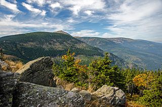
Giant Mountains National Park is a National Park in the Giant Mountains in the Sudetes in southwestern Poland, along the border with the Czech Republic.

Wigry National Park is a national park in Podlaskie Voivodeship in north-eastern Poland. It covers parts of the Masurian Lake District and Augustów Primeval Forest. It is named after lake Wigry, the largest of the park's many lakes. It is also classed as a Ramsar wetland site, one of 13 such sites in Poland.

Butrint National Park is a national park in Vlorë County, southern Albania. It is located 18 kilometres (11 mi) south of Sarandë. The park encompasses 9,424 hectares (94.24 km2) of hilly terrain with freshwater lakes, wetlands, salt marshes, open plains, reed beds and islands. The park's significance for conservation is reflected in the large number of species with over 1,200 different animals and plants. Its mandate includes the protection of the lake and lagoon of Butrint, the natural channel of Vivari, the islands of Ksamil and as well the archaeological site, that provides valuable remains of ancient civilisations.

Odaesan, also known as Mount Odae-san or Mount Odae, is a major cluster of mountains and national park in eastern Gangwon Province, South Korea, standing at the junction of Gangneung City, Pyeongchang County and Hongcheon County. It stands at the junction of the Taebaek Mountains and the Charyeong Mountains, a spur range stretching to the west and serving to divide the South Han River / Namhan River from the North Han River / Bukhan River. It stands just to the south of Seoraksan and north of Dutasan along the Baekdu-daegan Mountain-system mainline, the range of granite peaks that make up the symbolic spine of the Korean Peninsula, but its peaks are more rounded and forested than most. National Highway 6 runs through the park, between the south main-entrance and the northeast corner descending to the east coast. It contain five main peaks surrounding a deep main valley running north to south, and several other subsidiary peaks, such as Noin-bong, with gorges between, a watershed forming a river leaving this area to the south. Just outside the western boundary of the national park area, another mountain Gyebangsan rises to 1,577 m (5,174 ft), higher than conventional Odae-san's summit, and they are connected by a 10 km long ridge; it is controversial whether or not to include this within the cluster or consider it as separate.
The Curraghs or Ballaugh Curraghs are a wetland in Ballaugh parish in the north-west of the Isle of Man. The area has a rich and varied biodiversity and is also the location of the Curraghs Wildlife Park, a zoo and nature reserve that incorporates the wetlands.

Rawa Aopa Watumohai National Park is a national park on the Indonesian island of Sulawesi, in the province of South East Sulawesi. It was declared in 1989 and has an area of 1,050 km². The park ranges from sea level to an altitude of 981 m. It contains the Aopa peat swamp, the largest in Sulawesi, and is recognised as a wetland of international importance.

The Aammiq Wetland is the largest remaining freshwater wetland in Lebanon, a remnant of much more extensive marshes and lakes that once existed in the Bekaa Valley. It has been designated an Important Bird Area in the Middle East, is included in the Directory of Wetlands in the Middle East, was declared Ramsar Convention site number 978 in 1999, and most recently (2005) was designated, with Al Shouf Cedar Nature Reserve, a “Biosphere reserve” by UNESCO.

Cors Caron is a raised bog in Ceredigion, Wales. Cors is the Welsh word for "bog". Cors Caron covers an area of approximately 349 hectares. Cors Caron represents the most intact surviving example of a raised bog landscape in the United Kingdom. About 44 different species groups inhabit the area including various land and aquatic plants, fish, insects, crustaceans, lichen, fungi, terrestrial mammals and birds.
Hay-Zama Lakes is a 586-square-kilometre (226 sq mi) inland wetland and wildland park in northwestern Alberta, Canada. It was designated a Ramsar wetland of international importance on May 24, 1982, and is recognized as an Important Bird Area. It "constitutes one of the most extensive sedge wetlands in western North America".
The High Moor, Yongneup of Mt. Daeam is a wetland in Korea. Like the meaning of its name 'dragon swamp of big rocky mountain', the summit of Mt. Daeam is formed of giant rocks. Near the peak of the mountain, there is a natural freshwater wetland called Yongneup. Its coastal length is 210 m and its width is 275 m. It is the first Korean wetland to be registered on the list of the Ramsar Convention of Wetlands in 1997.

Kolkheti National Park, is a national park located in Samegrelo-Zemo Svaneti and Guria in the historical region of Colchis in western Georgia. The wetlands of Central Kolkheti are a Wetland of International Importance, a Ramsar Site. It lies on a coastal plain on the Black Sea, between the mouths of the Tikori and Supsa and spanning the districts of Zugdidi, Khobi, Lanchkhuti, Senaki and Abasha. The park was established during 1998 and 1999 as part of Georgia's Integrated Coastal Management Project, which was backed financially by the World Bank (WB) and the Global Environmental Facility (GEF). Kolkheti National Park covers an area of 28,940 hectares and with protected wetlands protected area spans to 33710 hectares, incorporating the land of the former 500-hectare Kolkheti State Nature Reserve, which had been established in 1947, and its surrounding wetlands, including the lake Paliastomi. Because of its unique forests and wetlands, and high numbers of threatened species, the park was inscribed on the UNESCO World Heritage List as part of the Colchic Rainforests and Wetlands site in 2021.

The Blue Lake is one of only four cirque lakes found in mainland Australia. The other three, Cootapatamba, Albina, and Club, are shallower and are held entirely by terminal moraines. Blue Lake's valley contains the best-developed glacial features in the Kosciuszko National Park alpine area of New South Wales. It was recognised as a wetland of international importance on 17 March 1996 when a 320-hectare (790-acre) area, comprising the lake and its surrounds, including nearby Hedley Tarn, was designated Ramsar Site 800 under the Ramsar Convention on wetlands. The lake lies within the Australian Alps National Parks and Reserves.

Mai Pokhari is a wetland in Ilam District of Nepal that was designated a Ramsar site on 28 October 2008. It is a pilgrimage center for both Hindus and Buddhists. The lake within the wetland which reflects emerald waters has a circumference of about 1 kilometre (0.62 mi) and boats are operated. On the periphery of the lake there is the Maipokhari Botanical Garden of horticultural and ecological importance which houses a rock garden, an orchid house, plants collected from many regions of eastern Nepal, and a green house.

Meshchyora National Park covers extensive wetlands and pine/birch woodlands in the Meshchera Lowlands on the East European Plain in Vladimir Oblast, about 120 km east of Moscow. The wetland habitat provides for extremely rich biodiversity among the plants and animals. The area is associated with the medieval Meshchera tribe, from which the area takes its name. "Meshchyora" National Park (Мещёра) is not to be confused with "Meshchersky" (Мещёрский) National Park, which is just to the south, over the border in Ryazan Oblast. The Meshchyora NP is located entirely within the Oka River watershed. A small corner of the park touches on the border of the Moscow region. About 39% of the park territory is used and managed for agricultural purposes by local communities.

Meshchyorsky National Park covers extensive wetlands and pine/birch woodlands in the Meshchera Lowlands on the East European Plain in the northern section of Ryazan Oblast, Russia, about 120 km east of Moscow. The wetland habitat provides for extremely rich biodiversity among the plants and animals. "Meshchersky" (Мещёрский) National Park is not to be confused with "Meshchyora" (Мещёра) National Park, which is just to the north, over the border in Vladimir Oblast. The park protects a section of the Pra River, Lake Beloye, and associated wetlands and forests. About 54% of the park territory is used and managed for agricultural purposes by local communities.

For a small country, Albania is characterised by a considerable wealth of terrestrial and marine ecosystems and habitats with contrasting floral, faunal, and fungal species, defined in an area of 28,748 square kilometres. Most of the country is predominantly of Mediterranean character, comprehending the country's center and south, while the alpine affinity is more visible in the northeast.

Kobuleti Strict Nature Reserve is a protected area in Kobuleti Municipality, Adjara region of Georgia along the Black Sea coast in the northern part of the resort town Kobuleti. Kobuleti Protected Areas were established in 1998 to preserve unique wetland ecosystems recognized by the Ramsar Convention. Because of these wetland ecosystems, ancient forests, and the high biodiversity found within the reserve, it was inscribed on the UNESCO World Heritage List as part of the Colchic Rainforests and Wetlands in 2021.
Puget lowland forests is a temperate coniferous forest ecoregion the Pacific coast of North America, as defined by the World Wildlife Fund (WWF) categorization system.