Oddevall

Last updated

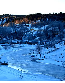
Oddevall is a village in Lier municipality, county of Buskerud, Norway. Oddevall and the neighboring village of Sjåstad are regarded as a single community with a combined population of 556 residents as of 1 January 2014. [1]

Lier, Norway Municipality in Buskerud, Norway

Lier is a municipality in Buskerud county, Norway. The administrative centre of the municipality is the village of Lierbyen. The municipality of Lier was established on 1 January 1838. The area Åssiden was transferred from Lier to the neighboring municipality of Drammen on 1 July 1951.

Buskerud County (fylke) of Norway

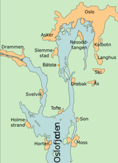
Buskerud is a county in Norway, bordering Akershus, Oslo, Oppland, Sogn og Fjordane, Hordaland, Telemark and Vestfold. The county extends from the Oslofjord and Drammensfjorden in the southeast to Hardangervidda mountain range in the northwest. The county administration is located in Drammen. Together with Akershus and Østfold, Buskerud will form the new, larger county Viken, from 1 January 2020.

Norway constitutional monarchy in Northern Europe

Norway, officially the Kingdom of Norway, is a Nordic country in Northern Europe whose territory comprises the western and northernmost portion of the Scandinavian Peninsula; the remote island of Jan Mayen and the archipelago of Svalbard are also part of the Kingdom of Norway. The Antarctic Peter I Island and the sub-Antarctic Bouvet Island are dependent territories and thus not considered part of the kingdom. Norway also lays claim to a section of Antarctica known as Queen Maud Land.

Related Research Articles

Grønlundfjellet Village in Østlandet, Norway

Grønlundfjellet is a village in the municipality of Gjerdrum, Norway. Its population (2005) is 2,174.

Svene

Svene is a village in the municipality of Flesberg in Buskerud, Norway. It is located in Numedal, 10 kilometres from Kongsberg. Its population (2017) is 376.

Folkestad is a village in Bø municipality, Norway. Its population is 422.

Herre, Norway urban area in Bamble, Telemark, Norway

Herre is a village in Bamble municipality, Norway. It is located west of Porsgrunn, across the Frierfjord. Its population is 1,356.

Åsgreina or Åsgrenda is a village in Nannestad municipality, Norway. Its population as of 2005 was 603, including that of the nearby village of Slattumhagen.

Sjåstad

Sjåstad is a village in Lier municipality, Buskerud county, Norway. Sjåstad and the neighboring village of Oddevall are regarded as one community. The two villages have a combined population of 556 (2014).

Båtstø

Båtstø is a small village in Buskerud, Norway.

Sem, Norway

Sem is a village in Tønsberg in Vestfold county, Norway.

Kjøpmannskjær is a village and statistical area (grunnkrets) in Nøtterøy municipality, Norway.

Buerstad is a village and statistical area (grunnkrets) in Nøtterøy municipality, Norway.

Torød is a village and statistical area (grunnkrets) in Nøtterøy municipality, Norway. it was also taken over by the Germans and soldiers lived in some houses. The statistical area Torød, which also can include the peripheral parts of the village as well as the surrounding countryside, has a population of 637.

Strengsdal is a village and statistical area (grunnkrets) in Nøtterøy municipality, Norway.

Årøysund

Årøysund is a village and statistical area (grunnkrets) in Nøtterøy municipality, Norway.

Hårkollen is a village and statistical area (grunnkrets) in Nøtterøy municipality, Norway.

Duken is a village and statistical area (grunnkrets) in Nøtterøy municipality, Norway.

Vollen is a village and statistical area (grunnkrets) in Nøtterøy municipality, Norway.

Ormelet is a village and statistical area (grunnkrets) in Tjøme municipality, Norway.

Hulebakk is a village and statistical area (grunnkrets) in Tjøme municipality, Norway.

Tranby Place

Tranby is a village in Lier municipality in Buskerud, Norway. Tranby is located approximately 25 minutes drive southwest of Oslo and 10 minutes drive north of Drammen.

Nesoddtangen Village in Østlandet, Norway

Nesoddtangen is a village and the administrative centre of the municipality of Nesodden in Akershus, Norway.

References

Coordinates: 59°51′43″N10°13′02″E / 59.8619°N 10.2172°E / 59.8619; 10.2172

Geographic coordinate system Coordinate system

A geographic coordinate system is a coordinate system that enables every location on Earth to be specified by a set of numbers, letters or symbols. The coordinates are often chosen such that one of the numbers represents a vertical position and two or three of the numbers represent a horizontal position; alternatively, a geographic position may be expressed in a combined three-dimensional Cartesian vector. A common choice of coordinates is latitude, longitude and elevation. To specify a location on a plane requires a map projection.