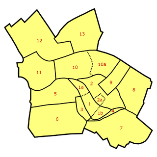
Founded about 1200, the Nikolaiviertel (help·info) of Alt-Berlin, together with nearby Cölln, jointly make up the reconstructed historical heart of the German capital of Berlin. It is located in Mitte locality, five minutes away from Alexanderplatz.
Barnim is a district in Brandenburg, Germany. It is bounded by Poland, the district of Märkisch-Oderland, the city state of Berlin and the districts of Oberhavel and Uckermark.
Märkisch-Oderland is a Landkreis (district) in the eastern part of Brandenburg, Germany. Neighboring are the district Barnim, the country Poland, the district-free city Frankfurt (Oder), the district Oder-Spree and the Bundesland Berlin. The administrative seat is Seelow but the largest town is Strausberg.
Dahme-Spreewald is a district in Brandenburg, Germany. It is bounded by the districts of Oder-Spree, Spree-Neiße, Oberspreewald-Lausitz, Elbe-Elster and Teltow-Fläming, and by the city of Berlin.
Oder-Spree is a Kreis (district) in the eastern part of Brandenburg, Germany. Neighboring are the district Märkisch-Oderland, the district-free city Frankfurt (Oder), Poland, the districts Spree-Neiße and Dahme-Spreewald, and the Bundesland Berlin.
Oberspreewald-Lausitz is a Kreis (district) in the southern part of Brandenburg, Germany. Neighboring districts are Dahme-Spreewald, Spree-Neiße, the districts Bautzen and Meissen in Saxony, and the district Elbe-Elster.
Spree-Neiße is a Kreis (district) in the southern part of Brandenburg, Germany. Neighboring districts are the districts Niederschlesischer Oberlausitzkreis and Kamenz in Saxony, the districts Oberspreewald-Lausitz, Dahme-Spreewald and Oder-Spree. The district-free city Cottbus is surrounded by the district. To the east is Poland.
Cölln was the twin city of Old Berlin (Altberlin) from the 13th century to the 18th century. Cölln was located on the Fisher Island section of Spree Island, opposite Altberlin on the western bank of the River Spree, until the cities were merged by Frederick I of Prussia to form Berlin in 1710. Today, the former site of Cölln is the historic core of the modern Mitte locality of the Berlin-Mitte borough in central Berlin.
Lower Lusatia is a historical region in Central Europe, stretching from the southeast of the German state of Brandenburg to the southwest of Lubusz Voivodeship in Poland. Like adjacent Upper Lusatia in the south, Lower Lusatia is a settlement area of the West Slavic Sorbs whose endangered Lower Sorbian language is related to Upper Sorbian and Polish.

Altstadt Spandau is the historic centre of the Spandau borough in the western suburbs of Berlin, situated on the right bank of the Havel river by its confluence with the Spree tributary. It arose near the site of a former Slavic gord during the German eastward expansion (Ostsiedlung) in the early 13th century. A castle at Spandowe, erected on a Havel island to secure the eastern borderlands of the Margraviate of Brandenburg, was already documented in an 1197 deed issued by the Ascanian margrave Otto II.
Amt Neuzelle is an Amt in the district of Oder-Spree, in Brandenburg, Germany. Its seat is in Neuzelle.
Amt Brieskow-Finkenheerd is an Amt in the district of Oder-Spree, in Brandenburg, Germany. Its seat is in Brieskow-Finkenheerd.
Amt Odervorland is an Amt in the district of Oder-Spree, in Brandenburg, Germany. Its seat is in Briesen.
Amt Scharmützelsee is an Amt in the district of Oder-Spree, in Brandenburg, Germany. Its seat is in Bad Saarow.
Amt Schlaubetal is an Amt in the district of Oder-Spree, in Brandenburg, Germany. Its seat is in Müllrose.
Amt Spreenhagen is an Amt in the district of Oder-Spree, in Brandenburg, Germany. Its seat is in Spreenhagen.
The Teltow Canal, also known as the Teltowkanal (help·info) in German, is a canal to the south of Berlin, the capital city of Germany. The canal lies in both the states of Berlin and Brandenburg, and at points forms the boundary between the two. It takes its name from the Brandeburgian region of Teltow and town of Teltow which lie on its course. The canal was constructed between 1900 and 1906, when it was opened by Wilhelm II.
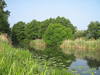
The Dahme Flood Relief Canal, or Dahme-Umflutkanal in German, is a canal in the German state of Brandenburg. Its principal purpose is to divert water from the upper reaches of the River Spree just below Leibsch, to run into the River Dahme at Märkisch Buchholz.

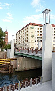
Mühlendamm is a major thoroughfare in the central Mitte district of Berlin, Germany. It runs from the historic Cölln and Fischerinsel quarters to the Molkenmarkt square of Alt-Berlin via the Mühlendammbrücke crossing the Spree river. Named after several watermills at the site, a historic causeway was first laid out at this location about 1200 and became the nucleus of the late medieval city foundation. The current prestressed concrete bridge was built in 1968. It is part of an east–west road link to Berlin's city centre and the Bundesstraße 1 highway.
Rathaus Bridge is a bridge in the central Mitte district of Berlin, Germany. Rebuilt in 2012, it is one of the oldest connections between the historic city centres of Alt-Berlin and Cölln across the Spree river. It is named after the nearby Rotes Rathaus city hall.
