Hjelmeland (help·info) is a municipality in Rogaland county, Norway. It is located in the traditional district of Ryfylke. The administrative centre of the municipality is the village of Hjelmelandsvågen. Other villages in the municipality include Fister, Årdal, and Jøsenfjorden.
Rennesøy is an island municipality in Rogaland county, Norway. It is located in the traditional district of Ryfylke. The administrative centre of the municipality is the village of Vikevåg. Other villages in Rennesøy include Askje and Sørbø. The municipality encompasses a number of islands on the south side of the Boknafjorden, north of the city of Stavanger.
Kvitsøy is an island municipality in Rogaland county, Norway. At only 6.29-square-kilometre (2.43 sq mi), it is the smallest municipality in Norway by area and one of the smallest by population. Kvitsøy is located in the traditional district of Ryfylke. The administrative centre of the municipality is the village of Ydstebøhamn on the island of Kvitsøy. The municipality is an archipelago located at the entrance to the large Boknafjorden. It sits about 2 nautical miles northwest of the mainland Stavanger peninsula. There are plans for the Rogfast tunnel to eventually connect Kvitsøy to the mainland road network.

Tysvær is a municipality in Rogaland county, Norway. It is part of the Haugalandet region. The municipality is located on the Haugalandet peninsula on the northern side of the Boknafjorden, just east of the towns of Kopervik and Haugesund. The administrative centre of the municipality is the village of Aksdal. Other villages in the municipality include Dueland, Førre, Grinde, Hervik, Hindaråvåg, Nedstrand, Skjoldastraumen, Susort, Tysvær, and Yrke.
Karmøy is a municipality in Rogaland county, Norway. It is southwest of the city of Haugesund in the traditional district of Haugaland. The administrative centre of the municipality is the town of Kopervik.

Haugaland or Haugalandet is a traditional district situated on the western coast of Norway. Haugaland is one of the 15 traditional districts located within the Vestlandet region.

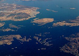
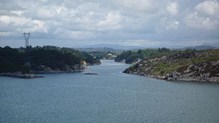
Boknafjord or Boknafjorden is a fjord located in Rogaland county, Norway. The huge fjord lies between the cities Stavanger and Haugesund, and the main part of the fjord is shared between the municipalities of Kvitsøy, Rennesøy, Finnøy, Tysvær, Bokn, and Karmøy. There are dozens of smaller fjords that branch off the main part of the fjord, reaching most municipalities in the county. At its longest, the Boknafjord reaches about 96 kilometres (60 mi) into the mainland at the innermost point of the Hylsfjorden. Other notable branches include the Saudafjorden, Sandsfjorden, Vindafjorden, Hervikfjorden, Førresfjorden, Erfjorden, Jøsenfjorden, Årdalsfjorden, Idsefjorden, Høgsfjorden, Lysefjorden, and Gandsfjorden.

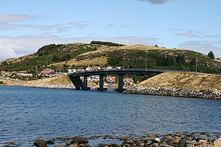
Karmsund is a strait located in Rogaland county, Norway. The 30-kilometre (19 mi) long strait divides the island of Karmøy on the west and the mainland of Norway and island of Vestre Bokn in the east. The strait runs through the municipalities of Haugesund, Karmøy, and Bokn. The town of Haugesund lies at the northern end of the strait and the town of Kopervik lies in the central part of the strait, and the village of Skudeneshavn lies near the southern end where the strait flows into the Boknafjorden. The Karmsund Bridge, a part of the European route E134 highway, links Karmøy to the mainland. The bridge was completed in 1955. The small islands of Vibrandsøy, Risøy, and Hasseløy lie in the strait at the northern end, just off shore from the town of Haugesund.
Skudenes is a former municipality in Rogaland county, Norway. It was part of the traditional district of Haugaland. The municipality existed from 1838 until its dissolution in 1965. Today the area is part of the municipalities of Bokn and Karmøy. Skudenes originally encompassed the southern part of the island of Karmøy and the three islands to the east: Vestre Bokn, Austre Bokn, and Ognøya. In 1849, the three smaller islands were separated to form Bokn municipality.

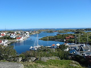
Ydstebøhamn or Ystabøhamn is the administrative centre of Kvitsøy municipality in Rogaland county, Norway. The village is located on the southern shore of the island of Kvitsøy. The village has a ferry quay which receives regular ferries from the town of Skudeneshavn on the island of Karmøy across the Boknafjorden to the north, and to the village of Mekjarvik in Randaberg municipality across the Kvitsøyfjorden on the mainland to the south. The planned Rogfast undersea tunnel will connect Kvitsøy to the mainland to the north and south as part of the government's goal of providing a ferry-free European route E39 highway along the west coast of Norway.

Føresvik is the administrative centre of Bokn municipality in Rogaland county, Norway. The village is located on the northeastern shore of the island of Vestre Bokn, along the rather narrow Boknasundet strait which separates Vestre Bokn from the island of Austre Bokn. The European route E39 highway runs through the village and the bridge connecting Vestre Bokn to Austre Bokn is also located in Føresvik.

Rogfast or the Rogaland Fixed Link is a sub-sea road tunnel under construction between the municipalities of Randaberg and Bokn in Rogaland county, Norway. The project will be a world record with respect to its 27-kilometre (17 mi) length and its maximum depth of 392 metres (1,286 ft) below sea level. This will be a part of the main European route E39 highway along the west coast of Norway and it will link the cities of Kristiansand – Stavanger – Haugesund – Bergen.
Vestre Bokn is an island in Bokn municipality in Rogaland county, Norway. The 36-square-kilometre (14 sq mi) island is the main island of the municipality. It lies on the northern side of the Boknafjorden at the southern end of the Karmsundet strait. Vestre Bokn lies between the islands of Karmøy and Austre Bokn and Ognøya. The main population centre on the island is the village of Føresvik, the administrative centre of the whole municipality. There are about 661 inhabitants on the island.

Mosterøy or Mosterøya is an island in Rennesøy municipality in Rogaland county, Norway. The 12-square-kilometre (4.6 sq mi) island lies just southwest of the island of Rennesøy. The smaller islands of Sokn, Bru, and Åmøy lie to the south of Mosterøy and the islands of Klosterøy and Fjøløy lie to the west of Mosterøy. All of these islands are connected together and to the mainland city of Stavanger by a series of undersea tunnels and bridges. The Mastrafjord Tunnel connects Mosterøy to the island of Rennesøy and the Askjesund Bridge connects Mosterøy to the island of Sokn. Both the tunnel and bridge are part of the European route E39 highway.
Austre Bokn is an island in Bokn municipality in Rogaland county, Norway. The 7.5-square-kilometre (2.9 sq mi) island lies on the northern side of the Boknafjorden between the islands of Ognøya and Vestre Bokn. It's connected to the other two islands and to the mainland by a series of bridges along the European route E39 highway. Both islands are separated from Austre Bokn by very small channels that are only about 250 to 350 metres wide.

Bokn Church is a parish church in Bokn municipality in Rogaland county, Norway. It is located in the village of Føresvik. The church is part of the Bokn parish in the Haugaland deanery in the Diocese of Stavanger. The white, wooden church was built in 1847 using plans by the architect Hans Linstow. The church seats about 300 people. There has been a church on this site since the middle ages. The first church here was probably a stave church. The present church is probably the third church on the site.

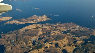
Karmøy is an island in the northwestern part of Rogaland county, Norway. The 176.8 square kilometres (68.3 sq mi) island makes up the majority of the municipality of Karmøy, along with the islands of Feøy, some smaller surrounding islands, and part of the mainland south of Haugesund. It is the largest island in Rogaland county. The island is separated from the mainland by the Karmsundet strait. The Boknafjorden lies to the south and southeast of the island. The Sirafjorden lies to the west, separating Karmøy from the islands of Utsira and Feøy.