
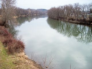
The Erie Canal is a historic canal in upstate New York that runs east-west between the Hudson River and Lake Erie. Completed in 1825, the canal was the first navigable waterway connecting the Atlantic Ocean to the Great Lakes, vastly reducing the costs of transporting people and goods across the Appalachians. In effect, the canal accelerated the settlement of the Great Lakes region, the westward expansion of the United States, and the economic ascendancy of New York State. It has been called "The Nation's First Superhighway."

Palmyra is a town in southwestern Wayne County, New York, United States. The population was 7,975 at the 2010 census. The town is named after the ancient city Palmyra in Syria.

Ralph Straus Regula was an American politician from Ohio. A member of the Republican Party, he served in the Ohio House of Representatives, the Ohio State Senate and the United States House of Representatives. He represented Ohio's 16th congressional district for 18 terms from 1973 to 2009. In the 110th Congress (2007–2009), he was the second longest serving Republican member of the House of Representatives.

Cuyahoga Valley National Park is an American national park that preserves and reclaims the rural landscape along the Cuyahoga River between Akron and Cleveland in Northeast Ohio.
The Little Miami Railroad was a railway of southwestern Ohio, running from the eastern side of Cincinnati to Springfield, Ohio. By merging with the Columbus and Xenia Railroad in 1853, it created the first through-rail route from the important manufacturing city of Cincinnati to the state capital, Columbus. In this period, railroads were important for creating connections between the important waterways of the Great Lakes and the Ohio River, which were major transportation routes for products to other markets.
The Tuscarawas River is a principal tributary of the Muskingum River, 129.9 miles (209 km) long, in northeastern Ohio in the United States. Via the Muskingum and Ohio rivers, it is part of the watershed of the Mississippi River, draining an area of 2,590 square miles (6,700 km2) on glaciated and unglaciated portions of the Allegheny Plateau.
The Potomac Heritage Trail, also known as the Potomac Heritage National Scenic Trail or the PHT, is a designated National Scenic Trail corridor spanning parts of the mid-Atlantic region of the United States that will connect various trails and historic sites in Virginia, Maryland, Pennsylvania, and the District of Columbia. The trail network includes 710 miles (1,140 km) of existing and planned sections, tracing the natural, historical, and cultural features of the Potomac River corridor, the upper Ohio River watershed in Pennsylvania and western Maryland, and a portion of the Rappahannock River watershed in Virginia. The trail is managed by the National Park Service and is one of three National Trails that are official NPS units.

The Great Allegheny Passage (GAP) is a 150-mile (240 km) rail trail between Pittsburgh, Pennsylvania and Cumberland, Maryland. Together with the C&O Canal towpath, the GAP is part of a 335 mi (539 km) route between Pittsburgh and Washington, D.C., that is popular with through hikers and cyclists.

The Ohio and Erie Canal was a canal constructed during the 1820s and early 1830s in Ohio. It connected Akron with the Cuyahoga River near its outlet on Lake Erie in Cleveland, and a few years later, with the Ohio River near Portsmouth. It also had connections to other canal systems in Pennsylvania.

The Old Erie Canal State Historic Park encompasses a 36-mile (58 km) linear segment of the original Erie Canal's Long Level section. It extends westward from Butternut Creek in the town of DeWitt, just east of Syracuse, to the outskirts of Rome, New York. The park includes restored segments of the canal's waterway and towpath which were in active use between 1825 and 1917. It is part of the New York State Park system.

The Great Lakes Seaway Trail, formerly named and commonly known as the Seaway Trail, is a 518-mile (834 km) National Scenic Byway in the northeastern United States, mostly contained in New York but with a small segment in Pennsylvania. The trail consists of a series of designated roads and highways that travel along the Saint Lawrence Seaway—specifically, Lake Erie, the Niagara River, Lake Ontario, and the Saint Lawrence River. It begins at the Ohio state line in rural Erie County, Pennsylvania, and travels through several cities and villages before ending at the Seaway International Bridge northeast of the village of Massena in St. Lawrence County, New York. It is maintained by the non-profit Seaway Trail, Inc.

Camillus Erie Canal Park is a town park in Camillus, New York that preserves a seven-mile (11 km) stretch of the Erie Canal. It includes the Nine Mile Creek Aqueduct, which is listed on the National Register of Historic Places. The aqueduct underwent a $2 million restoration, completed in August 2009, which brought it back to navigable condition.
Parks & Trails New York is New York's leading statewide advocate for parks and trails, dedicated since 1985 to improving our health, economy, and quality of life through the use and enjoyment of green space.
The Erie Canalway National Heritage Corridor is a National Heritage Area in New York State.
The Ohio and Erie Canalway National Heritage Area is a federally designated National Heritage Area in northeastern Ohio that incorporates the routes of the Ohio and Erie Canal, the Cuyahoga Valley Scenic Railroad, and portions of Cuyahoga Valley National Park.The heritage area follows the path of the canal along the Cuyahoga River for 110 miles (180 km) from Cleveland through Akron and Massillon to New Philadelphia, while the railway runs from Cleveland to Akron to Canton.
The New York State Canalway Trail is a network of multi-use trails that runs parallel to current or former sections of the Erie, Oswego, Cayuga-Seneca, and Champlain canals. When completed, the system will have 524 miles (843 km) of trails following current and former sections of the canals. The longest of these is the 365 miles (587 km) long Erie Canalway Trail. The Erie and Champlain Canalway Trails are also part of the statewide Empire State Trail system.

The Ohio & Erie Canalway Scenic Byway is a 110-mile (177 km) scenic byway located within the Ohio & Erie Canalway National Heritage Area in Northeast Ohio.

The Ohio and Erie Canal Towpath Trail is a multi-use trail that follows part of the former route of the Ohio & Erie Canal in Northeast Ohio.
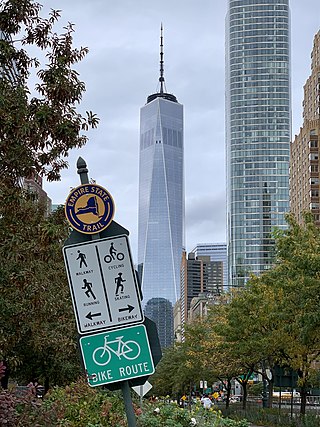
The Empire State Trail is a multi-use trail in New York State that was proposed by Governor Andrew Cuomo in January 2017 and completed in December 2020. The trail runs from Manhattan north to the Canadian border in Rouses Point near the northern tip of Lake Champlain, and also from Buffalo to Albany. At 750 miles (1,210 km), it is the longest multi-use trail in the United States. The trail includes pre-existing trail segments, which retain their existing identity but are now co-signed as a segment of the Empire State Trail. The trail also links to other regional bicycling and hiking trails such as the Appalachian Trail, the Adirondack and Catskill Parks, the Great Lakes Seaway Trail, the Genesee Valley Greenway, and others. A segment near its southernmost part, on the Hudson River Greenway in Manhattan, is concurrent with the East Coast Greenway. The trail is used for hiking, biking, snowshoeing, cross-country skiing and in some areas snowmobiling.