Ohio State Route 542

Last updated

OH-542.svg

State Route 542
OH 542 map.svg
Route information
Maintained by ODOT
Length 15.81 mi [1] (25.44 km)
Existed 1937 – present
Major junctions
South endOH-212.svg SR 212 near Sherrodsville
 OH-39.svg SR 39 in Dellroy
North endOH-183.svg SR 183 in Magnolia
Location
Counties Carroll
Highway system
OH-541.svg SR 541 SR 543 OH-543 (1927).svg

State Route 542 (SR 542) is a state highway in western Carroll County, within the eastern side of Ohio. The route runs 15.8 miles (25.4 km) long and connects SR 212 near Sherrodsville to Magnolia at SR 183 by way of Dellroy and Atwood Lake.

A state highway, state road, or state route is usually a road that is either numbered or maintained by a sub-national state or province. A road numbered by a state or province falls below numbered national highways in the hierarchy. Roads maintained by a state or province include both nationally numbered highways and un-numbered state highways. Depending on the state, "state highway" may be used for one meaning and "state road" or "state route" for the other.

Carroll County, Ohio County in the United States

Carroll County is a county located in the state of Ohio. As of the 2010 census, the population was 28,836. Its county seat is Carrollton. It is named for Charles Carroll of Carrollton, the last surviving signer of the Declaration of Independence.

Ohio State of the United States of America

Ohio is a Midwestern state in the Great Lakes region of the United States. Of the fifty states, it is the 34th largest by area, the seventh most populous, and the tenth most densely populated. The state's capital and largest city is Columbus.

Contents

Route description

SR 542 begins at an intersection with SR 212 in Monroe Township. The route heads north-northeast on a slight incline. Near the apex of this incline, the route winds around some hills and gets within the view of Atwood Lake. As the road curves to the east, entrances to numerous villages on the lake shoreline line the highway. SR 542 enters the village limits of Dellroy on Main Street and reaches a signalized intersection with Smith Avenue. At this intersection, SR 39 heads to the south on Smith Avenue and east on Main Street; SR 542 heads to the west on Main and to the north on Smith. To the north of the intersection, the route passes through a small business district, residential homes, and a small park before curving northwest and crossing Atwood Lake on a causeway. After the causeway, SR 542 turns due west and crosses more small tributaries of the lake and passes near more small villages surrounding the lake. Before crossing the last bridge over the lake, the route turns north into hilly terrain. Shortly after entering the village of Magnolia on Main Street, the route ends at an intersection of Main Street and Carrollton Street. SR 183 heads west on Carrollton Street and continues north on Main Street from this point. [2] The intersection is located about 0.03 miles (48 m) south of the Carroll–Stark county line. [3]

Monroe Township, Carroll County, Ohio Township in Ohio, United States

Monroe Township is one of the fourteen townships of Carroll County, Ohio, United States. As of the 2010 census, the population was 2,072, 1,670 of whom lived in the unincorporated portions of the township.

Ohio State Route 39 highway in Ohio

State Route 39 is a primarily east–west running state highway in north-central and northeastern portion of the U.S. state of Ohio. The route runs through seven counties on its approximately 155-mile (249 km) trip through the region. Its western terminus is at State Route 103 near New Washington, and its eastern terminus is at PA 68 near East Liverpool.

Stark County, Ohio County in the United States

Stark County is a county located in the U.S. state of Ohio. As of the 2010 census, the population was 375,586. Its county seat is Canton. The county was created in 1808 and organized the next year. It is named for John Stark, an officer in the American Revolutionary War.

History

The road realignment project south of Magnolia ongoing in 2014 Ohio 542 straightening.JPG
The road realignment project south of Magnolia ongoing in 2014

SR 542 was first designated on an alignment between Dellroy and Magnolia in 1937. [4] [5] The route at its designation was a gravel road but was fully paved by 1955. [6] This alignment would remain until 1967 when SR 542 was extended south of Dellroy to SR 212. [7] [8] In 2014, a straightening project was initiated about two and a half miles (4.0 km) south of Magnolia on a sharp curve with a descent in elevation. [9] The 2,000-foot-long (610 m) realignment project was completed on November 17, 2014. [10] A 0.21-mile-long (0.34 km) segment of the old road, officially designated SR 542-J remains to serve existing access points. [1]

Gravel road type of unpaved road surfaced with gravel

A gravel road is a type of unpaved road surfaced with gravel that has been brought to the site from a quarry or stream bed. They are common in less-developed nations, and also in the rural areas of developed nations such as Canada and the United States. In New Zealand, and other Commonwealth countries, they may be known as 'metal roads'. They may be referred to as 'dirt roads' in common speech, but that term is used more for unimproved roads with no surface material added. If well constructed and maintained, a gravel road is an all-weather road.

Major intersections

The entire route is in Carroll County.

Locationmi [1] kmDestinationsNotes
Monroe Township 0.000.00OH-212.svgI-77.svg SR 212 (Cumberland Road) to I-77  Sherrodsville
Dellroy 5.198.35OH-39.svg SR 39 (Main Street / Smith Avenue) New Philadelphia, Carrollton
Magnolia 15.8125.44OH-183.svgOH-800.svg SR 183 (Main Street / Carrollton Street) to SR 800  Minerva, Alliance
1.000 mi = 1.609 km; 1.000 km = 0.621 mi

Related Research Articles

Ohio State Route 281 highway in Ohio

State Route 281 is an east–west state highway in the northwestern portion of the U.S. state of Ohio. Its western terminus is at U.S. Route 24 approximately four miles (6.4 km) northeast of downtown Defiance, and its eastern terminus is at US 6 nearly one mile (1.6 km) north of Bradner. The majority of the route is known as the Defiance Pike.

Ohio State Route 269 highway in Ohio

State Route 269 is a north–south state highway in the north central portion of the U.S. state of Ohio. Its southern terminus is at SR 4 on the Huron–Seneca county line nearly seven miles (11 km) south of Bellevue, and its northern terminus is at the entrance to East Harbor State Park near Marblehead.

Ohio State Route 26 highway in Ohio

State Route 26 is a 67-mile-long (108 km) north–south route in south eastern Ohio spanning from SR 7 in Marietta to SR 148 between Jerusalem and Bethesda. SR 26 also passes through Graysville and Woodsfield. Where the state route designation ends in Wayne Township, the road continues north as Belmont County Road 26 where it connects to the Barkcamp State Park and the National Road. Much of the route parallels the Little Muskingum River and travels through the heart of Wayne National Forest's Marietta Unit.

Ohio State Route 220 highway in Ohio

State Route 220 is an east–west state highway in the south central portion of the U.S. state of Ohio. Its western terminus is at SR 772 about 8.25 miles (13.28 km) west of Waverly, and its eastern terminus is at the SR 32/SR 124 concurrency 3 miles (4.8 km) east of Piketon. The entire route is in Pike County.

Ohio State Route 49 highway in Ohio

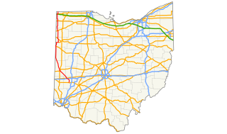
State Route 49 is a state highway in the western part of the U.S. state of Ohio. It begins in Drexel, an area within the city of Trotwood, at US 35 and runs northwesterly to Greenville, and then runs roughly along near the western edge of the state near the Indiana state line to the Michigan state line where it meets with Michigan's M-49.

Ohio State Route 424 highway in Ohio

State Route 424 was an east–west state highway in the northwestern portion of the U.S. state of Ohio. The route was a former section of US 24 that ran parallel to the Maumee River and Miami and Erie Canal between the cities of Defiance and Napoleon. First designated in 1964, the western terminus of the route for most of its history was at an intersection with US 24 west of Defiance, though between 2008 and when the route was fully removed from the state highway system in 2012, it was at the Defiance County/Henry County line. Its eastern terminus was at a dead end near the US 6 / US 24 interchange east of Napoleon.

Ohio State Route 518 highway in Ohio

State Route 518 is an east–west state highway located entirely in Columbiana County in northeast Ohio. The western terminus of SR 518 is at SR 644 north of Summitville. Its eastern terminus is at the concurrency of U.S. Route 30 (US 30) and SR 45 near West Point.

Ohio State Route 355 highway in Ohio

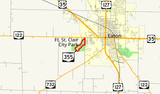
State Route 355 was a short 1.37-mile-long (2.20 km) state highway in southwestern Ohio. The route served the former Fort St. Clair State Memorial in Eaton, Preble County. The route began at SR 122 in western Eaton, traveled south along Camden Road for about 0.3 miles (0.48 km) before turning into the memorial, looping through the entire site, and ending at itself just south of the route's start at SR 122. The route was removed from the state highway system shortly after the park's jurisdiction was transferred from the state to the City of Eaton.

Ohio State Route 212 highway in Ohio

State Route 212 is a two-lane east–west state highway that runs within Stark, Tuscarawas, Carroll, and Harrison Counties in eastern Ohio. The western terminus of SR 212 is at U.S. Route 250 near Beach City, and its eastern terminus is at SR 151 in Bowerston. The route passes through rural areas but passes through small villages including Beach City, Bolivar, Zoar, Sherrodsville, and Leesville. It largely follows the valleys formed by the Tuscarawas River and Conotton Creek.

Ohio State Route 362 highway in Ohio

State Route 362 is a 4.56-mile (7.34 km) north–south state highway in the western part of the U.S. state of Ohio. It serves to connect Lake Loramie State Park with SR 66. Its southern terminus is in Fort Loramie at the intersection of North Main Street (SR 66) and Elm Street. near the northern edge of Fort Loramie. SR 362 then runs about 1.1 miles (1.8 km) east, then turns north at its intersection with Fort Loramie–Swanders Road. SR 362 then runs northerly along the western edge of Lake Loramie and Lake Loramie State Park before turning northwesterly then westerly and enters Minster and reaches its northern terminus at the intersection of South Main Street (SR 66) and First Street.

Ohio State Route 374

State Route 374 is north–south state highway in Hocking County, Ohio, located in the southern portion of the state. Its southern terminus is over 4 miles (6.4 km) east of the unincorporated village of South Bloomingville at State Route 56, and its northern terminus is near the unincorporated village of Rockbridge at US 33, west of Logan. The road serves Hocking State Forest as well as Hocking Hills State Park, and the entire highway is part of the designated Hocking Hills Scenic Byway.

Ohio State Route 651

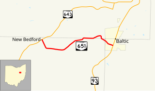
State Route 651 is a short state highway located in the vicinity of the tripoint of Coshocton, Holmes, and Tuscarawas Counties in Ohio. The route is 3.98 miles (6.41 km) long and is signed east–west. Its western terminus is at SR 643 in the unincorporated community of New Bedford and its eastern terminus is at SR 93 in the village of Baltic.

Ohio State Route 668

State Route 668 is a north-south state highway in central Ohio. Its southern terminus is at an intersection with SR 93 in the Wayne National Forest, northeast of Logan; its northern terminus is at an intersection with US 40 in the unincorporated community of Brownsville.

Ohio State Route 674

State Route 674 is a state highway located southeast of Columbus, Ohio. Most of the route straddles a county line; about 11 miles (18 km) of the southern part of route is on the Pickaway–Fairfield County line while the next 1.4 miles (2.3 km) is on the Fairfield-Franklin County line. The route's southern terminus is at US 22 just north of Stoutsville while the northern terminus is at an interchange with US 33 in the city of Canal Winchester.

Ohio State Route 729 highway in Ohio

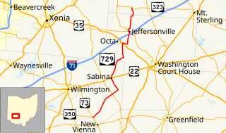
State Route 729 is a state highway in central Ohio. The 33.58-mile-long (54.04 km) route runs from SR 73 and SR 350 in the community of Snow Hill, northwest of New Vienna to SR 323 north of Jeffersonville.

References

  1. 1 2 3 "DESTAPE - Carroll County" (PDF). Ohio Department of Transportation. August 30, 2017. Retrieved December 6, 2017.
  2. Google (October 23, 2013). "Ohio State Route 542" (Map). Google Maps . Google. Retrieved October 23, 2013.
  3. ODOT. "Technical Services Straight Line Diagrams - SR 183 - Carroll County" (PDF). Retrieved October 23, 2013.
  4. 1936 Official Highway Map (MrSID) (Map). Cartography by John Jaster, Jr., Director. Ohio Department of Highways. 1936. Retrieved August 19, 2013.
  5. Official Ohio Highway Map 1937 (MrSID) (Map). Cartography by John Jaster, Jr., Director. ODOH. 1937. Retrieved August 19, 2013.
  6. Ohio Highway Map 1955 (MrSID) (Map). Cartography by S.O. Linzell, Director. ODOH. 1955. Retrieved September 23, 2013.
  7. 1967 Official Highway Map (MrSID) (Map). Cartography by P.E. Masheter, Director. ODOH. 1967. Retrieved September 22, 2013.
  8. 1969 Official Ohio Highway Map (MrSID) (Map). Cartography by P.E. Masheter, Director. ODOH. 1969. Retrieved September 22, 2013.
  9. "SR 542 safety improvement project to begin south of Magnolia". ODOT. 2014-04-14.
  10. "State Route 542 traffic to be moved onto new alignment Monday" (Press release). ODOT. November 12, 2014. Retrieved January 1, 2016.

Route map: Google

KML file (edithelp)
KML is from Wikidata