Related Research Articles

Mount Hutt rises to the west of the Canterbury Plains in the South Island of New Zealand, above the braided upper reaches of the Rakaia River, and 80 kilometres west of Christchurch. Its summit is 2190 metres above sea level.
The Jordan River is a name given to two minor rivers in the South Island of New Zealand, one in Marlborough, the other in Tasman. Further south, there is also 4 km (2.5 mi) stream in Otago named River Jordan.
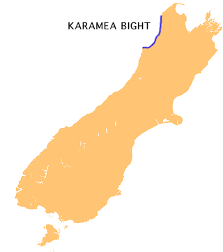
The Karamea Bight is the name given to a large bay in the Tasman Sea formed by a curved stretch of the West Coast of New Zealand's South Island. It stretches for 100 kilometres north from Cape Foulwind to just north of the mouth of the Heaphy River.

The Usarp Mountains are a major mountain range in North Victoria Land, Antarctica. They are west of the Rennick Glacier and trend north to south for about 190 kilometres (118 mi). The mountains are bounded to the north by Pryor Glacier and the Wilson Hills. They are west of the Bowers Mountains.
The Papahaua Range is a mountain range on the West Coast of New Zealand's South Island east of the town of Westport. It is a geological continuation of the Paparoa Range that is south of the Buller River and it runs north from the Buller Gorge to the Mōkihinui River. At its north end, it meets the Glasgow Range.

Crooked River is a river that flows from headwaters in the Southern Alps to Lake Brunner in the West Coast region of New Zealand's South Island. It is named for the erratic path it takes. Near Lake Brunner, it passes through reasonably flat farmland, but closer to its source, it rushes through gorges and rapids. One tributary is the Poerua River from Lake Poerua.

The Kokatahi River is a river of the West Coast Region of New Zealand's South Island. A major tributary of the Hokitika River, it flows northwest from its origins on the northern slopes of Mount Ambrose, reaching the Hokitika River 12 kilometres from the latter's mouth at Hokitika. The two rivers between them share one of the West Coast's larger floodplains.
The Little Totara River is a river of the northwest of New Zealand's South Island. It rises on the northern slopes of Mount Euclid in the Paparoa Range, flowing northwest to its confluence with the Tōtara River at the latter's mouth on the Tasman Sea seven kilometres north of Charleston.
The Motupiko River is a river of the Tasman Region of New Zealand's South Island. A major tributary of the Motueka River, it flows north from its origins southeast of the Hope Saddle, meeting the Motueka at Kohatu Junction, 15 kilometres west of Wakefield. The Motupiko's tributaries include the Rainy River.
The Nancy River is a river of the West Coast Region of New Zealand's South Island. A tributary of the Ahaura River, it flows generally southwest from its source to the west of Mount Hochstsetter in the Southern Alps, turning west shortly before its outflow, 15 kilometres southeast of Lake Hochstetter.
The Orikaka River is a river of the West Coast Region of New Zealand's South Island. It flows southwest from the southern end of the Matiri Range before turning south to flow into the Buller River five kilometres to the west of Inangahua.
The Penk River is a river of the Marlborough Region of New Zealand's South Island. It flows predominantly south from its origins on the slopes of Mount Horrible to reach the Awatere River 35 kilometres (22 mi) southwest of Seddon.

The Ruakōkoputuna River is a river of the Wairarapa, in the Wellington Region of New Zealand's North Island. It flows northeast from its sources within Haurangi Forest Park to the east of Palliser Bay, reaching the Huangarua River 10 kilometres (6 mi) south of Martinborough. The river's upper section flow through the Patuna Chasm, a narrow slot canyon.
The Te Wharau or Stony River is a river of the West Coast Region of New Zealand's South Island. It flows generally east from its sources in the Paparoa Range to reach the Inangahua River 15 kilometres north of Reefton.
The Tutaki River is a river of the Tasman Region of New Zealand's South Island. It flows north from its sources southwest of Lake Rotoroa to reach the Mangles River 10 kilometres east of Murchison.
Grey County was one of the counties of New Zealand in the South Island.
Molar Massif is a large mountain massif immediately east of the Lanterman Range in the Bowers Mountains of Antarctica. It was mapped by the United States Geological Survey (USGS) from ground surveys and United States Navy air photos, 1960–1964. The descriptive name was applied by the United States Advisory Committee on Antarctic Names (US-ACAN) because, when viewed in plan, the outline of the massif resembles a molar tooth.
Kalang River, a perennial river of the Bellinger River catchment, is located in the Mid North Coast region of New South Wales, Australia.
The Greymouth Borough was the borough council covering the urban part of Greymouth, New Zealand between 1868 and 1989, when it became part of Grey District.
References
"Place name detail: Okari River". New Zealand Gazetteer. New Zealand Geographic Board . Retrieved 12 July 2009.
41°50′S171°28′E / 41.833°S 171.467°E