Okhaldhunga

Last updated
Okhaldhunga
ओखलढुङ्गा
Nepal adm location map.svg
Red pog.svg
Okhaldhunga
Location in Nepal
Coordinates: 27°19′N86°30′E / 27.317°N 86.500°E / 27.317; 86.500
CountryFlag of Nepal.svg    Nepal
Zone Sagarmatha Zone
District Okhaldhunga District
Elevation
1,561 m (5,121 ft)
Population
 (1991)
  Total3,761
Time zone UTC+5:45 (Nepal Time)

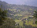
Okhaldhunga is the headquarters of the Okhaldhunga District in the Sagarmatha Zone of Nepal. At the time of the 1991 Nepal census it had a population of 3761 living in 790 individual households. [1]

Contents

Climate

Climate data for Okhaldhunga, elevation 1,731 m (5,679 ft), (1991–2020)
MonthJanFebMarAprMayJunJulAugSepOctNovDecYear
Mean daily maximum °C (°F)15.8
(60.4)
18.1
(64.6)
21.8
(71.2)
24.6
(76.3)
25.2
(77.4)
25.4
(77.7)
24.9
(76.8)
25.1
(77.2)
24.6
(76.3)
23.6
(74.5)
20.8
(69.4)
17.4
(63.3)
22.3
(72.1)
Daily mean °C (°F)10.6
(51.1)
12.6
(54.7)
16.2
(61.2)
19.1
(66.4)
20.3
(68.5)
21.3
(70.3)
21.3
(70.3)
21.4
(70.5)
20.6
(69.1)
18.7
(65.7)
15.4
(59.7)
12.1
(53.8)
17.5
(63.5)
Mean daily minimum °C (°F)5.3
(41.5)
7.1
(44.8)
10.5
(50.9)
13.6
(56.5)
15.3
(59.5)
17.2
(63.0)
17.7
(63.9)
17.6
(63.7)
16.6
(61.9)
13.7
(56.7)
10.0
(50.0)
6.7
(44.1)
12.6
(54.7)
Average precipitation mm (inches)12
(0.5)
14.9
(0.59)
25.8
(1.02)
66.5
(2.62)
153.6
(6.05)
292.9
(11.53)
418.0
(16.46)
415.7
(16.37)
265.0
(10.43)
61.2
(2.41)
8.0
(0.31)
8.2
(0.32)
1,741.8
(68.57)
Average precipitation days (≥ 1.0 mm)1.62.23.97.914.018.422.221.416.35.41.00.8115.1
Source: World Meteorological Organization [2]

Media

To promote local culture Okhaldhunga has two FM radio stations: Radio Likhu (91.3 MHz) and Ramailo Samudayek Radio (100.6 MHz), both of which are community radio stations. [3] [4] [5]

Related Research Articles

<span class="mw-page-title-main">Community radio</span> Community-owned and operated radio service

Community radio is a radio service offering a third model of radio broadcasting in addition to commercial and public broadcasting.

<span class="mw-page-title-main">Dhankuta</span> City in Koshi Province, Nepal

Dhankuta is a hill town and the headquarters of Dhankuta District in Koshi Province in Eastern Nepal. According to 2011 Nepal census, it has population of 26,440 inhabitants.

<span class="mw-page-title-main">Phungling Municipality</span> Municipality in Koshi Province, Nepal

Phungling Municipality is a municipality located in Taplejung District in the Koshi Province of Nepal. The municipality was formed merging the then two Village Development Committees of Phungling and Dokhu in May 2014. At the time of the 2011 Nepal census it had a population of 19,085 people and 4,480 individual households.

<span class="mw-page-title-main">Dharan</span> Sub-Metropolitan City in Koshi Province

Dharan is a sub-metropolitan city in Sunsari District of Koshi Province, in eastern Nepal, which was established as a fourth municipality in the Kingdom in 1958. It is the third most populous city in eastern Nepal after Biratnagar and Itahari. The Nepali word "dharan" means a saw pit. The rainforest from which the tree trunks came is still just on the edge of the city. Much later the British Gurkha camp opened in October 1960. The use of the camp by British Gurkhas finished in the mid-1990s. Dharan has an estimated city population of 173,096 living in 34,834 households as per the 2021 Nepal census. It is one of the cities of the Greater Birat Development Area which incorporates the cities of Biratnagar-Itahari-Gothgau-Biratchowk-Dharan primarily located on the Koshi Highway in Eastern Nepal, with an estimated total urban agglomerated population of 804,300 people living in 159,332 households. It is the largest city in the province number one by Area. It covers 192.32 square kilometers while Biratnagar and Itahari is 2nd and 3rd biggest cities by Area

<span class="mw-page-title-main">Sunuwar people</span> Ethnic group in South Asia

The Sunuwar or Koinch are a Tibeto-Burman ethnic group. a Kirati tribe native to Nepal, parts of India and southern Bhutan. They speak the Sunuwar language. According to the 2001 census of Nepal, 17% of the tribe follow the Kirant religion and adopt the Mundhum (Kiranti) culture.

<span class="mw-page-title-main">Okhaldhunga District</span> District in Koshi Province, Nepal

Okhaldhunga District is one of 14 districts of Koshi Province in eastern Nepal. The district, with the municipality of Okhaldhunga as its district headquarters, covers an area of 1,074.5 km2 (414.9 sq mi) and had a population of 156,702 in 2001 and 147,984 in 2011.

<span class="mw-page-title-main">Nepalgunj</span> Sub-Metropolitan City in Lumbini, Nepal

Nepalgunj, also spelled Nepalganj, is a Sub-Metropolitan City in Banke District, Nepal. It lies on the Terai plains near the southern border with Bahraich district in Uttar Pradesh, India. Nepalgunj is 153 kilometers south-west of Ghorahi and 16 km south of Kohalpur. Former Village Development Committee: Udayapur, Bhawaniyapur, Piprahawa, Jaispur, Paraspur, Indrapur, Khaskarkado, Bashudevpur, Manikapur and Puraina were added to territory in order to make it Sub metropolitan city on 2071 Paush 28 and later Puraini was also added in list on 2072 Paush 21. Further, while restructuring of local levels nationwide, ward no. 23 was taken out to Janaki Rural Municipality and ward no. 7 of Hirminiya VDC was added to Nepalgunj.

<span class="mw-page-title-main">Birendranagar</span> Municipality in Karnali, Nepal

Birendranagar officially Birendranagar Municipality is a city in Surkhet District in Karnali Province of Nepal. It is the capital city of Karnali province as well as the district headquarter of Surkhet district. As of March 2022, Birendranagar has a population of 154,886, making it the 17th most populous city of Nepal. Birendranagar is the largest city of Karnali province and 7th largest in Western Nepal. It is one of the fastest growing cities of Nepal and is on two national highways, Ratna Highway and Karnali Highway. It is one of the constituent city of the Ratna Highway Metropolitan Areas along with Nepalgunj and Kohalpur. Birendranagar compromises of panoramic view of Mahabharata and Chure ranges and the plain of the inner Terai. A major trade center in mid-western Nepal, Birendranagar is considered the most expensive city to live in Nepal.

Chailahi is a town and Village Development Committee in Dang Deokhuri District in Lumbini Province of south-western Nepal. At the time of the 1991 Nepal census it had a population of 10,800 persons living in 1485 individual households. It lies in the east west highway and lied 23 km east to districts capital Ghorahi.

Khiji Phalate is a part of Khiji Chandeshwari it has village development committee in Okhaldhunga District in the Sagarmatha Zone of mid-eastern Nepal. At the time of the 1991 Nepal census it had a population of 2944 living in 459 individual households.

<span class="mw-page-title-main">Dipayal Silgadhi</span> Municipality in Sudurpashchim Province, Nepal

Dipayal Silgadhi is a municipality and the district headquarters of Doti District in Sudurpashchim Province of Nepal. Previously, it also served as the headquarters of the Far-Western Development Region. It lies in the Lesser Himalayas on the bank of Seti River. At the time of the 2011 Nepal census it had a population of 32,941 people living in 7,447 individual households.

Sanghutar is a village development committee in Ramechhap District in the Janakpur Zone of north-eastern Nepal. At the time of the 1991 Nepal census it had a population of 2,177 people living in 394 individual households. The VDC has a small market called Sanghutar Bazaar, situated in the bank of the Likhu River and bordering Okhaldhunga District. The bazaar is flat land near to the bridge ; therefore, its name is Sanghutar. It is a main commercial center of many neighboring villages of Ramechhap and Okhaldhunga District with a higher secondary school called Himaganga.

Ishworpur is a Municipality in Sarlahi District in the Janakpur Zone of south-eastern Nepal. The municipality was established on 18 May 2014 by merging the existing Bela, Bhaktipur, Gaurishankar and Ishwarpur VDCs. At the time of the 1991 Nepal census it had a population of 14,014 people living in 249 individual households.

Khalanga is market center in Sharada Municipality in Salyan District of Karnali Province of Nepal. The place formerly existing as Village Development Committee was annexed to form a new municipality since 18 May 2014. It is the district headquarter of Salyan District. At the time of the 1991 Nepal census it had a population of 6380.

<span class="mw-page-title-main">Amargadhi</span> Place in Nepal

Amargadhi is a municipality and the district headquarter of Dadeldhura District in Sudurpashchim Province of western Nepal. It was named after Gorkha General Amar Singh Thapa, who fought in the Gurkha War between 1814 and 1816 At the time of the 2011 Nepal census it had a population of 21,245 people living in 4,778 individual households.

<span class="mw-page-title-main">Musikot, Western Rukum</span> Municipality in Karnali Province, Nepal

Musikot is a municipality and the district headquarter of Western Rukum District in Karnali Province of Nepal that was established as Musikot Khalanga on 2 December 2014 by merging the two former Village development committees Musikot and Khalanga. From 2014 until 2018, Musikot was called Musikot Khalanga and until 2017 served as the district headquarter of Rukum District. It lies on the bank of Sani Bheri River. It borders with Eastern Rukum in the east, Sanibheri rural municipality in the west, Banfikot rural municipality in the north and Tribeni rural municipality and Rolpa district in the south.

Prime Fm is a radio station in Banepa, Kavre, Nepal. It transmits on 104.5 MHz. It provides news, information and entertainment.

<span class="mw-page-title-main">Koshi Province</span> Province of Nepal

Koshi Province is the autonomous easternmost province adopted on 20 September 2015 by Constitution of Nepal. The province is rich in natural resources, tourist attractions, recreational activities, and natural beauty. The province covers an area of 25,905 km2 (10,002 sq mi), about 17.5% of the country's total area. With the industrial city of Biratnagar as its capital, the province includes major eastern towns of Birtamod, Sundar Haraincha, Damak, Dharan, Itahari, Triyuga Municipality and Mechinagar, and the Mount Everest, Kangchenjunga and Ama Dablam. Koshi River, the largest river of the nation, forms the province's western boundary. Under the First-past-the-post voting system issued by the Constituency Delimitation Commission, Nepal, the province hosts 28 parliamentary seats and 56 provincial assembly seats.

Khijidemba is a part of Khiji Chandeshwari it has 2017 rural municipality (gaunpalika) out of seven rural municipality located in Okhaldhunga District of Province No. 1 of Nepal. There are a total of 8 municipalities in Okhaldhunga in which 1 is urban and 7 are rural.

Likhu is a rural municipality (gaunpalika) out of seven rural municipality located in Okhaldhunga District of Province No. 1 of Nepal. There are a total of 8 municipalities in Okhaldhunga in which 1 is urban and 7 are rural.

References

  1. "Nepal Census 2001", Nepal's Village Development Committees, Digital Himalaya, archived from the original on October 12, 2008, retrieved 15 November 2009.
  2. "World Meteorological Organization Climate Normals for 1991–2020". World Meteorological Organization. Retrieved 14 October 2023.
  3. "ASSOCIATION OF COMMUNITY RADIO BROADCASTERS NEPAL (ACORAB)::Introduction". www.acorab.org.np. Retrieved 2020-06-30.
  4. Network, Indigenous Community Radio. "Radio Likhu 91.3 MHz". Indigenous Community Radio Network. Retrieved 2020-06-30.
  5. Report on BHN visit to Radio Kairan and Radio Likhu in Ramechhap, archived from the original on 2021-12-21, retrieved 2020-06-30